

You are here
Avalanche Forecast for 2019-03-31 06:25
- EXPIRED ON April 1, 2019 @ 6:25 amPublished on March 31, 2019 @ 6:25 am
- Issued by Ryan Sorenson - Mount Shasta Avalanche Center
Bottom Line
Warm temperatures and sunny conditions remain on Mount Shasta. Low avalanche danger exists below, near and above treeline. Watch out for isolated windslab and loose-wet avalanches in extreme terrain. Normal caution is advised today.


Avalanche Problem 1: Normal Caution
-
Character ?

-
Aspect/Elevation ?
-
Likelihood ?CertainVery LikelyLikelyPossible
 Unlikely
 -
Size ?HistoricVery LargeLargeSmall

Using normal caution should grant safe passage through avalanche terrain today. Watch for small, isolated wind slabs along ridgelines. Large overhanging cornice features have formed on some ridgelines around the forecast area. Isolated loose-wet slides and large rollerballs could form on steep solar aspects late this afternoon. If rollerballs and pinwheels begin to form, it might be time to head over to a different aspect, or back to the barn. Basic principles for safe travel today include:
- Always actively watch out for the 5 red flags of avalanche danger. These include wind blowing snow, recent avalanches, cracks/whoomfing, rapid warming, recent heavy snow.
- It is best to avoid travel directly below overhanging cornices.
- Be mindful of the overhead hazard of falling rime ice
- Limit time spent traveling under steep and exposed cliff features as these could shed with increasing solar energy.
- A helmet is recommended if travelling in steep terrain.
Large rollerballs were observed on Mount Shasta yesterday. Similar conditions are expected today.
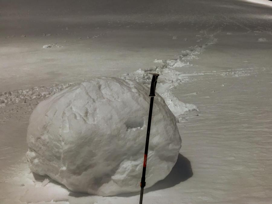
Photo: Large rollerball on south aspect 8,600 feet lower Casaval Ridge.
Forecast Discussion
The fireball will be high in the sky today. The sun can reflect off of snow surfaces intensifying the need for sunscreen and eye protection above treeline.
Recent Observations
Clear sunny skies were observed on Mount Shasta yesterday. Snow surfaces are smooth and soft. Variable wind and sun crusts have formed in spots. A deep right side up consolidated snowpack over a number of crusts exists above treeline.
Notable observations on Mount Shasta:
- Winds were calm with some light southwest wind above treeline on the mountain. Wind loading was minimal.
- Small drifts and cornice features have formed on Green Butte Ridge towards westerly aspects.
- Surface penetration: Boot: 3-6 inches, Ski: 2-4 inches @ 10,500 feet Lake Helen
- Wind: Calm / Blowing snow: Previous-yes; Active-No / Temperatures: High 20's F
- Rollerballs were observed on sunny aspects during periods of daytime warming
- Small to giant cornices adorn ridgelines all across the forecast area.
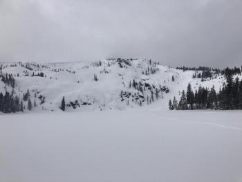
Looking up Avalanche Gulch from 9,400 feet Mount Shasta:
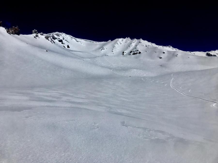 Photo: Nick Meyers
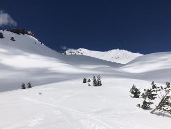

Weather and Current Conditions
Weather Summary
Expect another gorgeous sunny warm day on Mount Shasta with building clouds in the late afternoon. Calm winds this morning will increase slightly out of the west signaling a change in the weather. A warm front is moving into the area tomorrow morning. A half an inch of water will play out as snow/rain with snow levels near 8,000 feet. Lingering snow showers will remain until Tuesday night with snow levels dipping to 6,300 feet. A short dryer spell is expected on Wednesday then cooler showery conditions will return Thursday.
24 Hour Weather Station Data @ 6:00 AM
| Weather Station | Temp (°F) | Wind (mi/hr) | Snow (in) | Comments | ||||||||
|---|---|---|---|---|---|---|---|---|---|---|---|---|
| Cur | Min | Max | Avg | Avg | Max Gust | Dir | Depth | New | Water Equivalent | Settlement | ||
| Mt. Shasta City (3540 ft) | 29 | 27 | 58 | 42 | 1 | N | ||||||
| Sand Flat (6750 ft) | 23 | 15 | 46 | 31 | 142 | 0 | 0 | 3 | ||||
| Ski Bowl (7600 ft) | 25 | 18.5 | 33.5 | 28.5 | 184 | 0 | 0 | 3 | ||||
| Gray Butte (8000 ft) | 30 | 23 | 32.5 | 29 | 15 | 31 | E | |||||
| Castle Lake (5870 ft) | 0 | 0 | 0 | 0 | 0 | 0 | 0 | Station not responding | ||||
| Mount Eddy (6509 ft) | 24.5 | 19 | 40.5 | 31.5 | 2 | 8 | WSW | 145 | 0 | 2 | ||
| Ash Creek Bowl (7250 ft) | ||||||||||||
| Ash Creek Ridge (7895 ft) |
Two Day Mountain Weather Forecast
Produced in partnership with the Medford NWS
| For 7000 ft to 9000 ft | |||
|---|---|---|---|
|
Sunday (4 a.m. to 10 p.m.) |
Sunday Night (10 p.m. to 4 a.m.) |
Monday (4 a.m. to 10 p.m.) |
|
| Weather | Sunny | Increasing clouds in the evening | Rain/snow showers. Snow level 8,000 feet. |
| Temperature (°F) | 45 | 30 | 36 |
| Wind (mi/hr) | Southwest 0-5 | Southwest 5-10 | South 5-10 |
| Precipitation SWE / Snowfall (in) | / 0 | / 0 | / 2-3 |
| For 9000 ft to 11000 ft | |||
| Sunday | Sunday Night | Monday | |
| Weather | Sunny | Increasing clouds in the evening | Snow showers |
| Temperature (°F) | 30 | 28 | 30 |
| Wind (mi/hr) | West 10-15 | West 0 | Southwest 20-25 |
| Precipitation SWE / Snowfall (in) | / 0 | / 0 | / 2-6 |
Season Precipitation for Mount Shasta City
| Period | Measured (in) | Normal (in) | Percent of Normal (%) |
|---|---|---|---|
| From Oct 1, 2025 (the wet season) | 35.22 | 35.33 | 100 |
| Month to Date (since Jun 1, 2026) | 5.69 | 5.83 | 98 |
| Year to Date (since Jan 1, 2026) | 26.81 | 20.12 | 133 |

