Submitted by nmeyers on Fri, 03/31/2023 - 5:42am
Recent Observations:
- A whopper of a storm earlier this week brought upwards of 2 feet of fresh snow to the forecast area. This snow fell within a 24-36 hour period on Monday and Tuesday
- Two large avalanches have been observed, both in the Eddy mountains on east/northeast facing slopes, near and above treeline. One was snowmobile triggered, the other natural, both occurring on 3/29. These slides failed on older melt-freeze crusts with a weak layer of graupel sandwiched in between the new and old snow
- A decent size loose wet avalanche was reported on Black Butte, also on 3/29
- On the east side of the interstate in the Mount Shasta / Gray Butte zones, no avalanches have been observed or reported
- Wind has been predominantly light out of the south/southeast, averaging 8 mi/hr with gusts to 20 mi/hr over the past 3 days
- Temperatures have averaged 19° F, with a low of 9° and high of 31°
- Preserved powder exists on northerly facing slopes above 6,500 feet
- The fresh snow has received 2 days of settlement, approximately 7 inches. Yesterday, the snow received a good baking. Variable crusts on sun kissed slopes are likely today
- Near treeline on Mount Shasta, 205 inches of snow remains on the ground. At Castle Lake, 180 inches. Mount Eddy, 170 inches. Ash Creek Butte, 175+ inches (snow depth sensor buried)
Mountain Weather:
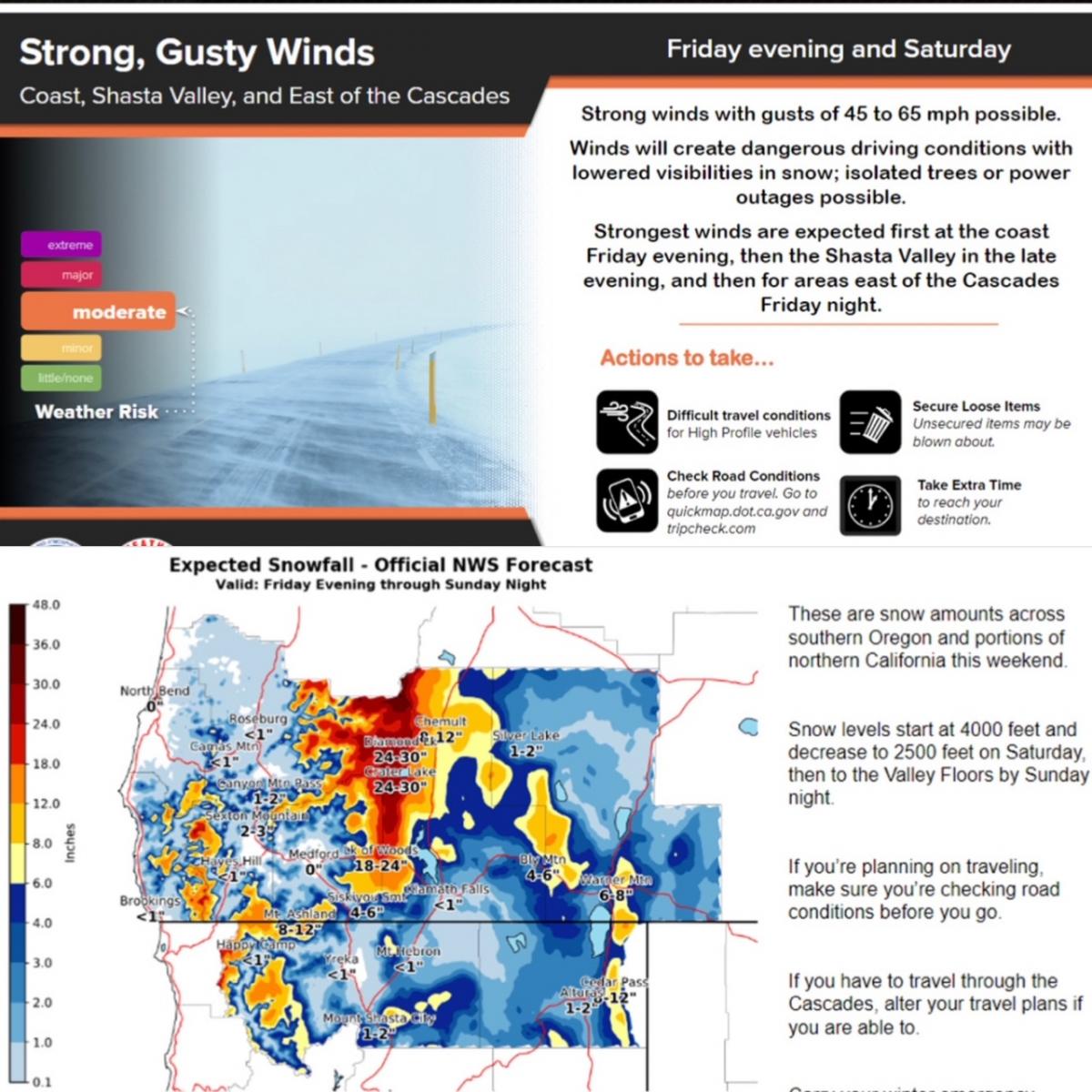
The forecast area remains under west/northwest flow aloft. Light showers across the area are expected today. A front arrives this evening, slowly moving onshore. With westerly flow, the bulk of the precipitation will be along the coast and coastal ranges, as well as western Siskiyou County, where up sloping effects are the greatest. Snow levels will be around 2,500 feet. Westerly wind will increase this afternoon. Another round of mountain snow is expected through the day Saturday. Longer term, rain and snow showers will continue.

Today 7-8 Weather :
Snow likely, mainly after 11am. Chance of precipitation, 80 percent. Snow level near 3,800 feetToday 7-8 Wind Direction:
SToday 8-9 Weather:
Snow likely, mainly after 11am. Mostly cloudy. WindyToday 8-9 Wind Direction:
WTomorrow 7-8 Weather:
Snow before 11am, then snow showers after 11am. The snow could be heavy at times. Chance of precipitation, 100 percent. Snow level near 3,900 feetTomorrow 7-8 Wind Direction:
STomorrow 8-9 Weather:
Snow before 11am, then showers after 11am. Snow could be heavy at times. WindyTomorrow 8-9 Wind Direction:
WTonight 7-8 Weather:
Snow likely, mainly after 11pm. Mostly cloudy. Snow level near 4,100 feetTonight 7-8 Wind Direction:
STonight 8-9 Weather:
Snow likely, mainly after 11pm. Mostly cloudy. WindyTonight 8-9 Wind Direction:
WToday 7-8 Temp:
29Today 8-9 Temp:
20Tomorrow 7-8 Temp:
28Tomorrow 8-9 Temp:
19Tonight 7-8 Temp:
28Tonight 8-9 Temp:
1826
2
29
16
146
0
0
19
9
31
22
205.2
0
0.01
Grey Butte Temp Cur:
18.5Grey Butte Temp Min:
15Grey Butte Temp Max:
29.5Grey Butte Temp Avg:
22Grey Butte Wind Cur:
14.5Grey Butte Wind Max:
15Grey Butte Wind Gust Max:
49.07Grey Butte Wind Avg:
WNWCastle Lake Snow Depth:
181.7Castle Lake Snow New:
0Mount Eddy Temp Cur:
21.5Mount Eddy Temp Min:
16.5Mount Eddy Temp Max:
32.5Mount Eddy Temp Avg:
26Mount Eddy Wind Cur:
2Mount Eddy Wind Max:
2.5Mount Eddy Wind Gust Max:
5.42Mount Eddy Wind Avg:
ESEMount Eddy Snow Depth:
170.9Mount Eddy Snow New:
0Ash Creek Bowl Temp Cur:
21.5Ash Creek Bowl Temp Min:
12.5Ash Creek Bowl Temp Max:
30.5Ash Creek Bowl Temp Avg:
22.5Ash Creek Bowl Snow New:
0Ash Creek Ridge Temp Cur:
17Ash Creek Ridge Temp Min:
15Ash Creek Ridge Temp Max:
24Ash Creek Ridge Temp Avg:
19.5Ash Creek Ridge Wind Cur:
0Ash Creek Ridge Wind Max:
0Ash Creek Ridge Wind Gust Max:
0Mt. Shasta City Temp Cur:
31Mt. Shasta City Temp Min:
22Mt. Shasta City Temp Max:
48Mt. Shasta City Temp Avg:
36Mt. Shasta City Wind Cur:
0Mt. Shasta City Wind Min:
0Mt. Shasta City Wind Max:
6Mt. Shasta City Wind Avg:
1Mt. Shasta City Wind Avg:
NSki Bowl Comments:
Water content downGrey Butte Wind Min:
1.5Grey Butte Wind Avg:
10Caslte Lake Comments:
Temp sensor downMount Eddy Wind Min:
0Mount Eddy Wind Avg:
1.5Ash Creek Ridge Wind Min:
0Ash Creek Ridge Wind Avg:
0Sand Flat Snow Settlement:
1Ski Bowl Snow Settlement:
3.7Castle Lake Snow Settlement:
1.5Mount Eddy Snow Settlement:
5.2Ash Creek Bowl Snow Settlement:
0.1Measured Precipitation Oct:
39.7Normal Precipitation Oct:
30.38Percent Precipitation Oct:
131Measured Precipitation MTD:
9.99Normal Precipitation MTD:
5.44Percent Precipitation MTD:
184Measured Precipitation YTD:
30.57Normal Precipitation YTD:
18.14Percent Precipitation YTD:
169Today SWE:
0.05Tonight SWE:
0.06Tomorrow SWE:
0.19Today Wind Max 7-9:
17Tonight Wind Max 7-9:
19Tomorrow Wind Max 7-9:
22Today Wind Min 7-9:
7Tonight Wind Min 7-9:
11Tomorrow Wind Min 7-9:
12Today Wind Max 9-11:
32Tonight Wind Max 9-11:
43Tomorrow Wind Max 9-11:
54Today Wind Min 9-11:
22Tonight Wind Min 9-11:
33Tomorrow Wind Min 9-11:
44Today Snow Max 7-9:
2.00Tonight Snow Max 7-9:
3.00Tomorrow Snow Max 7-9:
7.00Today Snow Min 7-9:
1.00Tonight Snow Min 7-9:
1.00Tomorrow Snow Min 7-9:
3.00Today Snow Max 9-11:
2.00Tonight Snow Max 9-11:
3.00Tomorrow Snow Max 9-11:
7.00Today Snow Min 9-11:
1.00Tonight Snow Min 9-11:
1.00Tomorrow Snow Min 9-11:
3.00Ash Creek Bowl HS:
158.4Weather Station Discussion:
The table below summarizes data reported from all of our weather stations over the last 24 hours.Seasonal Stats Discussion:
The wet season is October 1 through May 1. The table below summarizes recorded vs. normal precipitation amounts for the City of Mount Shasta. Overall Danger Rating:
ModerateCurrent Time:
3:00 AM


