

You are here
Avalanche Advisory for 2017-03-08 06:41:43
- EXPIRED ON March 9, 2017 @ 6:41 amPublished on March 8, 2017 @ 6:41 am
- Issued by Nick Meyers - Shasta-Trinity National Forest
Bottom Line
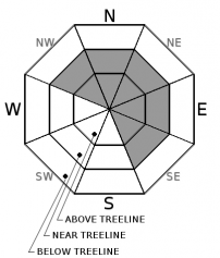
Above treeline today, the avalanche danger is CONSIDERABLE for new and existing wind slabs. Evaluate terrain and conditions carefully. Pay special attention as you approach above treeline terrain where the wind slab problem remains. Near treeline and below treeline, MODERATE avalanche danger will prevail.


Avalanche Problem 1: Wind Slab
-
Character ?

-
Aspect/Elevation ?
-
Likelihood ?CertainVery LikelyLikelyPossible
 Unlikely
 -
Size ?HistoricVery LargeLargeSmall

Wind slabs have gained size and depth over the past few days with some natural and human triggered activity both on Mt Shasta and in the Castle Lake area. Continued westerly winds will be strong enough today for the wind slab problem to remain ongoing, especially above treeline in exposed areas. New wind slabs may have the ability to step down into deeper layers of the snowpack if triggered. Look for signs of recently formed wind slabs such as cornice features and wind pillows. Identify and avoid areas where wind slabs exist.
Forecast Discussion
Warming temperatures have aided in stabilizing our snowpack and this trend will continue. That said, concern still remains for above treeline terrain where existing and potentially new wind slabs will remain. Light density snow has consolidated considerably, however there is still plenty of snow available for transport. Think about your terrain choices and the conseqences. We've had several red flags of avalanche danger over the past few days including new snow, wind, recent avalanches and whumphing in the snowpack. Remain dilligent with your backcountry skiing and riding choices today. A few larger cornices could remain touchy, but most smaller cornices have likely stabilized from the warming trend.
Recent Observations
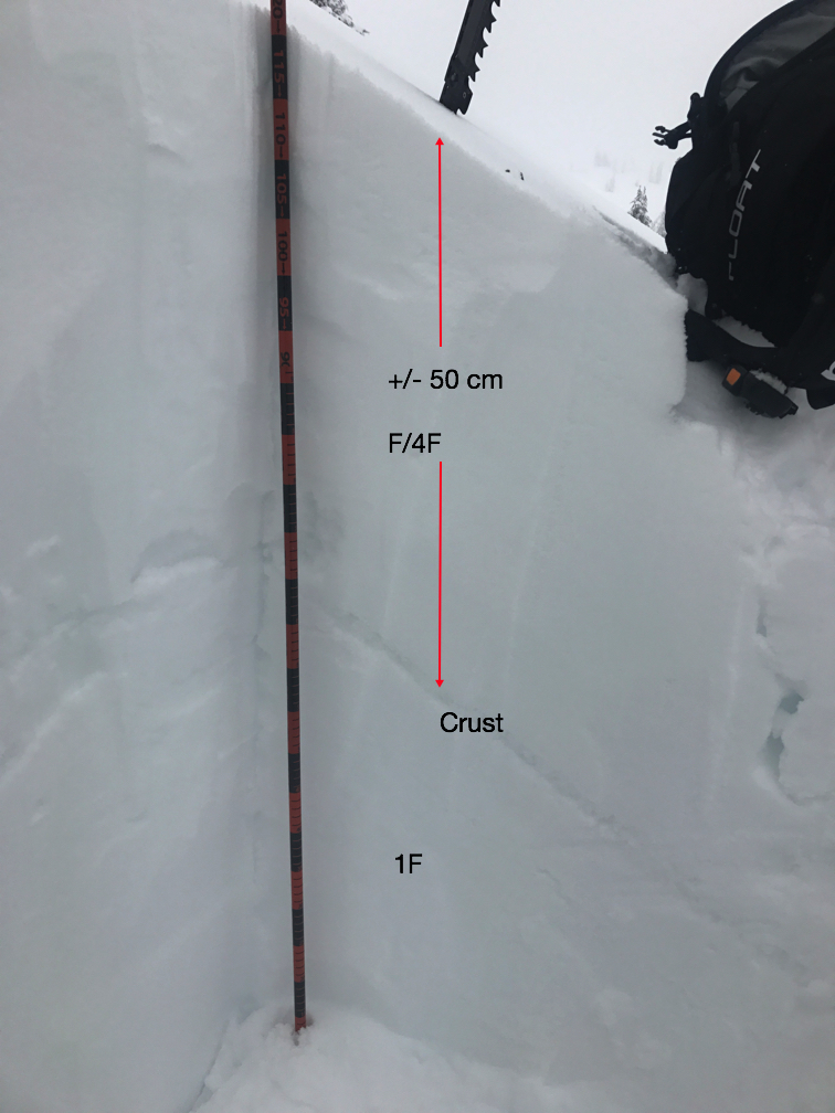
Temperatures have warmed upwards of 9 degrees across the forecast area this morning. Yesterday, the Old Ski Bowl station recorded a 17 degree jump in only 2 hours (1300-1500). Due to poor visibility yesterday, it was difficult to get a good look at avalanche terrain on the upper mountain. Observations were made on Gray Butte however. Warming temperatures were felt throughout the day. Weather stations have reported several inches of settlement in the snowpack. Slabby snow conditions were observed above 7,500 feet when the effects of the wind were noticed. Winds have been primarily out of the west/northwest. Easterly aspects were noticably wind loaded. South/southeast aspects had effects of cross loading (lee's of trees and rock out crops drifted) with some areas scoured to the old crust. On a northeasterly aspect just below the Gray Butte summit towers, about 50cm of soft snow sits on top of our old rain crust layer. One skier heard whumphing in the snowpack on this same aspect. Snowpit compression tests found weak layers within the top 20-30 cm of the snowpack, however propagation could not be produced in large column tests. Bonding of old snow/new snow was good.
 .
.
Weather and Current Conditions
Weather Summary
Showers contine with warming temperatures. Snow levels will rise to near 5,000 feet today, 7,500 feet tonight and upwards of 8,500 feet tomorrow. Precipitation amounts look light. Over the next 24 hours, we should see only a few inches of new snow at best in the high country and of course rain on snow for lower elevations. A building upper level ridge will bring a break in the action later in the week.
===========================================================
In Mt Shasta City at 0500, we have a current temperature of 35 F.
On Mt Shasta (South Side) in the last 24 hours...
Sand Flat - 6750 ft, the current temperture is 29 degrees F. Temperatures have ranged from 24 F to 32 F. Snow on the ground totals 120 inches with a trace of new snow and 1 inch of settlement.
Old Ski Bowl - 7,600ft. the current temperture is 28 degrees F. Temperatures have ranged from 20 F to 57 F. Snow on the ground totals 198 inches with a trace of new snow and 2 inches of settlement.
Gray Butte - 8,000 feet, the current temperature is 27 degrees F. Temperatures have ranged from 19 F to 27 F. Winds have averaged 15 mph with gusts to 28 out of the west/northwest.
Mt Eddy Range (West side of Interstate-5)...
Castle Lake - 5,800 feet, the current temperature is 29 degrees F. Temperatures have ranged from 25 F to 38 F. Snow on the ground totals 120 inches with a trace of new snow.
Mt Eddy - 6,500 feet, the current temperature is 31 degrees F. Temperatures have ranged from 22 F to 31 F. Snow on the ground measures 112 inches with a trace of new snow and 2 inches of settlement. Winds have been east/southeast in nature, averaging 1-2 mph with gusts to 15 mph.
THIS SEASON PRECIPITATION for MT SHASTA CITY: Since October 1st (the wet season), we have received 43.67 inches of water, normal is 31.23 inches, putting us at 139% of normal. For the month of March, we have received .36 inches of water, normal is 1.73, which is 20 % of normal. And finally for the year of 2017, we received 22.51 inches of water, normal is 16.02 inches, putting us at 140% of normal.
Always check the weather before you attempt to climb Mt Shasta. Further, monitor the weather as you climb. Becoming caught on the mountain in any type of weather can compromise life and limb. Be prepared.
| 0600 temperature: | 29 |
| Max. temperature in the last 24 hours: | 32 |
| Average wind direction during the last 24 hours: | West/Northwest |
| Average wind speed during the last 24 hours: | 15 mi/hr |
| Maximum wind gust in the last 24 hours: | 28 mi/hr |
| New snowfall in the last 24 hours: | 0-1 inches |
| Total snow depth: | 120 inches |
Two Day Mountain Weather Forecast
Produced in partnership with the Medford NWS
| For 7000 ft to 9000 ft | |||
|---|---|---|---|
|
Wednesday (4 a.m. to 10 p.m.) |
Wednesday Night (10 p.m. to 4 a.m.) |
Thursday (4 a.m. to 10 p.m.) |
|
| Weather | Mostly cloudy. Chance of snow this morning, then rain and snow likely this afternoon. | Cloudy with a 50 percent chance of rain. | Cloudy with a 30 percent chance of rain. |
| Temperature (°F) | 41 | 34 | 50 |
| Wind (mi/hr) | South 10 mph | South 10 mph | South 10 mph |
| Precipitation SWE / Snowfall (in) | / 0-.5 | / .10-.25 water | / 0 |
| For 9000 ft to 11000 ft | |||
| Wednesday | Wednesday Night | Thursday | |
| Weather | Snow likely, mainly after 10am. Mostly cloudy, windy. | Cloudy, chance of snow, windy. | Cloudy and windy, chance of snow. |
| Temperature (°F) | 28 | 28 | 32 |
| Wind (mi/hr) | West 35-40 mph | West 1-2 | West 30-35 mph |
| Precipitation SWE / Snowfall (in) | / 1-2 | / 1-3 | / 0-1 |

