

You are here
Avalanche Advisory for 2017-03-12 07:02:46
- EXPIRED ON March 13, 2017 @ 7:02 amPublished on March 12, 2017 @ 7:02 am
- Issued by Nick Meyers - Shasta-Trinity National Forest
Bottom Line
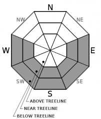
LOW avalanche danger exists this morning. Later today, an overall cloudless sky with daytime highs 3 to 5 degrees warmer than yesterday will contribute to rising avalanche danger. Slopes E-SE-S-SW-W facing near treeline and below treeline could see small to medium size loose wet point releases. Most of these will be triggered by falling rime ice and/or backcountry riders. For these reasons, expect MODERATE loose wet avalanche danger this afternoon due to intense daytime warming and direct sunshine.


Avalanche Problem 1: Loose Wet
-
Character ?

-
Aspect/Elevation ?
-
Likelihood ?CertainVery LikelyLikelyPossible
 Unlikely
 -
Size ?HistoricVery LargeLargeSmall

Today, loose wet point releases will likely be triggered either below a ski turn or from falling rime ice. Slopes below 9,000 feet and primarily E-SE-S-SW-W facing during the mid afternoon hours will have the best chance of producing small loose wet slides. Move to a different aspect if you note roller balls, pinwheels, other loose wet slides and/or sinking up to your boot tops in soft snow.
A loose wet slide is a release of unconsolidated snow or slush. It starts at a point and entrains snow as it moves down hill. A terrain trap such as a gully, cliff or flat lake can magnify the conseqences of loose wet avalanches.
Forecast Discussion
Today is going to be a warm one. Clouds are moving out and full sun is moving in. Loose wet avalanches can be notoriously hard to predict. The largest and most consequential loose wet slides usually occur later in the Spring when the snow on the upper ramparts of Mt Shasta (11,000 to 12,000 feet) becomes loose and unconsolidated from very warm days. These slopes are steep and host a long fetch giving plenty of time for snow to become entrained and gain mass. Most often, it's rime ice or rock triggered loose wet avalanches impacting climbers below that cause the most problems. Pay attention to who is above you today. It's a more likely scenario for somebody to trigger a loose wet on top of another skier skinning up than it is to be caught in a one. For climbers, watch for falling rime ice. Wear a helmet! Further, smooth and firm climbing conditions on the upper mountain warrant solid ice axe, self arrest and crampon skills.
Recent Observations
Observations were made on a long tour of the east and north sides of Mount Shasta yesterday. The glaciers are caked and looking great! Ridges remain scoured with exposed rocks. Bare ground is starting to show around some trees in the lower elevation Northgate area. Temperatures climbed into the 50's and low 60's below treeline. Near and above treeline on Shasta, high temps reached the mid to high 40's. The mountain developed a decent cloud cap for a portion of the day and the area fell under partly to mostly cloudy skies. For this reason, we didn't see as much loose wet activity other than a few small roller balls on lower elevation slopes. Rime ice is plastered on exposed rocks and falling rime ice onto slopes below has been the biggest cause of triggering loose wet slides. Tree bombs have also triggered some small loose wet point releases. Winds were calm during our tour however it was noted that northwest winds were higher on the mountain. A public observation on the south side of Mt Shasta in Avalanche Gulch observed crusty snow conditions from about 10,400 feet to about 9,400 feet. From 9,400 to approximately 7,600 feet decent corn snow was found. Below 7,600, mushy, soft snow challenged most. Last night we saw low temps reach near freezing which will help firm up the snow a bit today. While some may find some areas of nice corn snow near and just above treeline, the snowpack remains in a transitional phase toward a widespread melt/freeze cycle.
Weather and Current Conditions
Weather Summary
The clearing trend in the weather forecast will continue today. Daytime highs are exected to ante up, 3 to 5 degrees warmer than yesterday. Areas west of the Cascades will be under mostly sunny skies by this afternoon. Mild weather will continue through Tuesday. Winds look remarkably absent for all elevations. Expect a dowright gorgeous Sunday. Enjoy.
===========================================================
In Mt Shasta City at 0500, we have a current temperature of 32 F.
On Mt Shasta (South Side) in the last 24 hours...
Sand Flat - 6750 ft, the current temperture is 30 degrees F. Temperatures have ranged from 30 F to 52 F. Snow on the ground totals 109 inches with no new snow and 3 inches of settlement.
Old Ski Bowl - 7,600ft. the current temperature is 34 degrees F. Temperatures have ranged from 34 F to 47 F. Snow on the ground totals 184 inches with no new snow and 3 inches of settlement.
Gray Butte - 8,000 feet, the current temperature is 34 degrees F. Temperatures have ranged from 34 F to 44 F. Winds have averaged 15-20 mph with gusts to 42 out of the west/northwest.
Mt Eddy Range (West side of Interstate-5)...
Castle Lake - 5,800 feet, the current temperature is 36 degrees F. Temperatures have ranged from 36 F to 60 F. Snow on the ground totals 109 inches with no new snow and 1 inch of settlement.
Mt Eddy - 6,500 feet, the current temperature is 30 degrees F. Temperatures have ranged from 30 F to 51 F. Snow on the ground measures 101 inches with no new snow and 2 inches of settlement. Winds have averaged 2-4 mph with gusts to 11 mph, southwest.
THIS SEASON PRECIPITATION for MT SHASTA CITY: Since October 1st (the wet season), we have received 43.67 inches of water, normal is 32.15 inches, putting us at 135% of normal. For the month of March, we have received .36 inches of water, normal is 2.65 inches, which is 13% of normal. And finally for the year of 2017, we received 22.51 inches of water, normal is 16.94 inches, putting us at 132% of normal.
Always check the weather before you attempt to climb Mt Shasta. Further, monitor the weather as you climb. Becoming caught on the mountain in any type of weather can compromise life and limb. Be prepared.
| 0600 temperature: | 30 |
| Max. temperature in the last 24 hours: | 52 |
| Average wind direction during the last 24 hours: | West/Northwest |
| Average wind speed during the last 24 hours: | 5-10 mi/hr |
| Maximum wind gust in the last 24 hours: | 30-40 mi/hr |
| New snowfall in the last 24 hours: | 0 inches |
| Total snow depth: | 109 inches |
Two Day Mountain Weather Forecast
Produced in partnership with the Medford NWS
| For 7000 ft to 9000 ft | |||
|---|---|---|---|
|
Sunday (4 a.m. to 10 p.m.) |
Sunday Night (10 p.m. to 4 a.m.) |
Monday (4 a.m. to 10 p.m.) |
|
| Weather | Sunny | Mostly clear | Sunny |
| Temperature (°F) | 54 | 36 | 57 |
| Wind (mi/hr) | Northwest Calm | Northwest 5 mph | North/Northwest 5-10 mph |
| Precipitation SWE / Snowfall (in) | / 0 | / 0 | / 0 |
| For 9000 ft to 11000 ft | |||
| Sunday | Sunday Night | Monday | |
| Weather | Sunny | Mostly clear | Sunny |
| Temperature (°F) | 36 | 34 | 34 |
| Wind (mi/hr) | West 5-10 mph | West/Northwest 0 | West/Northwest 5-10 mph |
| Precipitation SWE / Snowfall (in) | / 0 | / 0 | / 0 |

