

You are here
Avalanche Advisory for 2017-03-17 05:56:37
- EXPIRED ON March 18, 2017 @ 5:56 amPublished on March 17, 2017 @ 5:56 am
- Issued by Nick Meyers - Shasta-Trinity National Forest
Bottom Line
LOW avalanche danger will preside over all elevations and aspects within the forecast area today.
Normal caution is advised.
Climbers, watch for falling rime ice as well as smooth and firm snow conditions on the upper mountain. Self-arrest is essential. Carry an ice axe and crampons and know how to use them. Wear a helmet.


Avalanche Problem 1: Normal Caution
-
Character ?

-
Aspect/Elevation ?
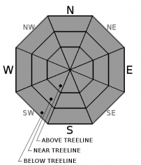
-
Likelihood ?CertainVery LikelyLikelyPossible
 Unlikely
 -
Size ?HistoricVery LargeLargeSmall

Overall, very manageable avalanche conditions exist for backcountry recreationalists today. On Mt Shasta, caution is warranted when traveling in exposed, steep terrain with high consequences where a slide for life is possible if one should slip and fall. Carry an ice axe and crampons and know how to use them. Don't forget to wear a helmet as falling rime ice is also is a significant risk.
Recent Observations
Temperatures are slightly cooler this morning with moderate winds out of the west/northwest. Daytime highs reached the mid to high 40's yesterday. Observations were made on a long tour up Shastina by a couple local folks. In a couple words, conditions were less than par and variable. One couldn't buy a recent sign of avalanche danger. The skiing was described as poor overall, but perhaps would have been better with a bit more heat. Overcast skies and flat light dominated most of the day. Below treeline, moist, wet and punchy snow was encountered with a rain glaze. Previous rain occurred all the way to Horse Camp, approximately 7,900 feet. Up to 10,000 feet, about 1-3 inches of new snow in the form of sloppy cream cheese was observed with some areas frozen. Exposed areas and the upper mountain gave way to wind scoured and firm snow with icy, bulbous patches. The forecast area hosts a strong snowpack with no recent signs of avalanche danger. New wind slabs did not verify from our most recent storm this week. Loose wet avalanches have not been observed.
Weather and Current Conditions
Weather Summary
Climate prediction models indicate above normal precipitation and below normal temperatures for the next several weeks. For the near future, low pressure offshore will move northeastward bringing a warm front through the area today. Clouds will be thickest to the west and gradually spread out to the east by this afternoon. Precipitation will be minimal, if any at all. Later tonight and into Saturday, a strong cold front will push onshore and generate strong winds, reaching advisory level locally. Rain will spread inland and we could see .3 to .4 inches of rain with snow levels near 7,000 to 7,500 feet during the day. Snow levels will lower Saturday night, but to little, to late to receive any awesome powder snow. Sunday, a warm front will move back in.
===========================================================
In Mt Shasta City at 0500, we have a current temperature of 33 F.
On Mt Shasta (South Side) in the last 24 hours...
Sand Flat - 6750 ft, the current temperture is 33 degrees F. Temperatures have ranged from 31 F to 43 F. Snow on the ground totals 101 inches with no new snow and 1 inch of settlement.
Old Ski Bowl - 7,600ft. the current temperature is 34 degrees F. Temperatures have ranged from 28 F to 44 F. Snow on the ground totals 175 inches with no new snow and 1 inch of settlement.
Gray Butte - 8,000 feet, the current temperature is 33 degrees F. Temperatures have ranged from 26 F to 36 F. Winds have averaged 15-20 mph with gusts to 35 mph out of the west/northwest.
Mt Eddy Range (West side of Interstate-5)...
Castle Lake - 5,800 feet, the current temperature is 36 degrees F. Temperatures have ranged from 32 F to 49 F. Snow on the ground totals 100 inches with no new snow and 1 inch of settlement.
Mt Eddy - 6,500 feet, the current temperature is 34 degrees F. Temperatures have ranged from 28 F to 41 F. Snow on the ground measures 91 inches with no new snow and 2 inches of settlement. Winds have averaged 1-3 mph with gusts to 9 mph, variable.
THIS SEASON PRECIPITATION for MT SHASTA CITY: Since October 1st (the wet season), we have received 43.91 inches of water, normal is 33.20 inches, putting us at 132% of normal. For the month of March, we have received .6 inches of water, normal is 3.70 inches, which is 16% of normal. And finally for the year of 2017, we received 22.75 inches of water, normal is 17.99 inches, putting us at 126% of normal.
Always check the weather before you attempt to climb Mt Shasta. Further, monitor the weather as you climb. Becoming caught on the mountain in any type of weather can compromise life and limb. Be prepared.
| 0600 temperature: | 33 |
| Max. temperature in the last 24 hours: | 43 |
| Average wind direction during the last 24 hours: | West/Northwest |
| Average wind speed during the last 24 hours: | 10-15 mi/hr |
| Maximum wind gust in the last 24 hours: | 35 mi/hr |
| New snowfall in the last 24 hours: | 0 inches |
| Total snow depth: | 101 inches |
Two Day Mountain Weather Forecast
Produced in partnership with the Medford NWS
| For 7000 ft to 9000 ft | |||
|---|---|---|---|
|
Friday (4 a.m. to 10 p.m.) |
Friday Night (10 p.m. to 4 a.m.) |
Saturday (4 a.m. to 10 p.m.) |
|
| Weather | A 20 percent chance of rain after 11am. Mostly cloudy. | A 50 percent chance of rain. Mostly cloudy. Breezy. | Rain before 11am, then rain and snow. High near 43. Windy. Chance of precipitation is 90%. Little or no snow accumulation expected. |
| Temperature (°F) | 50 | 38 | 45 |
| Wind (mi/hr) | South 10-15 mph | South 15-20 mph | South 15-20 mph |
| Precipitation SWE / Snowfall (in) | / 0 | / 0 | / 0-1 |
| For 9000 ft to 11000 ft | |||
| Friday | Friday Night | Saturday | |
| Weather | A 20 percent chance of snow after 11am. Mostly cloudy. Windy. | A 50 percent chance of snow. Mostly cloudy. Windy. | Snow. Windy. Chance of precipitation is 80%. |
| Temperature (°F) | 33 | 28 | 28 |
| Wind (mi/hr) | Southwest 35-40 mph | Southwest 0 | Southwest 50-55 mph |
| Precipitation SWE / Snowfall (in) | / 0 | / 1-2 | / 3-5 |

