

You are here
Avalanche Advisory for 2017-03-25 06:21:30
- EXPIRED ON March 26, 2017 @ 6:21 amPublished on March 25, 2017 @ 6:21 am
- Issued by Nick Meyers - Shasta-Trinity National Forest
Bottom Line
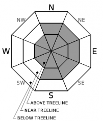
Above 6,500 feet, a foot of new snow over the past 36 hours accompanied by strong westerly winds has contributed to several avalanche problems for today. Human triggered avalanches are possible. Expect overall MODERATE avalanche danger for most aspects and elevations with CONSIDERABLE danger on leeward, NE-E-SE aspects above treeline. Slopes greater than 35 degrees should be approached with caution. Be able to make solid snow observations and don't ignore obvious signs of avalanche danger!


Avalanche Problem 1: Wind Slab
-
Character ?

-
Aspect/Elevation ?
-
Likelihood ?CertainVery LikelyLikelyPossible
 Unlikely
 -
Size ?HistoricVery LargeLargeSmall

Yesterday afternoon was likely our window of highest avalanche danger when about a foot of fresh snow took on a 20 degree F temperature spike. That said, above treeline terrain may not of experienced such a drastic temp spike and lingering instability could exist today. While sometimes we can get the classic Shasta Plaster and all things are good, this storm was a bit colder than we've been seeing lately. We have very limited above treeline observations. With significant new snow and strong westerly winds over the past two days, today is going to be the day to tip-toe around a bit and be willing to change your plans if signs of avalanche danger show. It's Saturday, skies may clear and certainly folks will be lured into the alpine terrain. Stay out of terrain traps, pick your up and down track wisely. Pay attention to who is above you. Think twice about laying down first tracks in any wind loaded bowl or chute above treeline or in exposed areas near treeline.
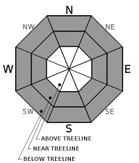
Avalanche Problem 2: Storm Slab
-
Character ?

-
Aspect/Elevation ?
-
Likelihood ?CertainVery LikelyLikelyPossible
Unlikely
-
Size ?HistoricVery LargeLargeSmall
The recent storm arrived cold and then experienced a rapid temperature spike. This made for wet surface snow on top of lighter density snow, cooking up an upside down stormsnow layering. These storm slabs have formed in wind protected areas near treeline and below treeline on all aspects. Look for areas of snow surface cracking while making fresh tracks either uphill or down. Avoid steep slopes in areas where snow surface cracking exists. Colder temperatures overnight may have locked things up for today, but it's still a good idea to keep this avalanche problem in mind, especially as the day warms.
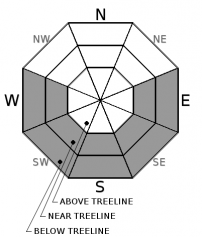
Avalanche Problem 3: Loose Wet
-
Character ?

-
Aspect/Elevation ?
-
Likelihood ?CertainVery LikelyLikelyPossible
Unlikely
-
Size ?HistoricVery LargeLargeSmall
We may or may not see any loose wet problems today... however, if the sun comes out and temperatures verifying, small to medium size loose wet avalanches are possible on southerly aspects below and near treeline. These will likely take on the form of roller balls and smaller point release style slides. The sun is getting higher in the sky this time of year and the effects of the sun are much greater. Recent new snow immediately followed by warm sun can create for loose-wet snow surfaces.
Forecast Discussion
We've got several avalanche problems on tap for today. With some sunshine and recent fresh snow...certainly folks will be out looking for some turns. The avalanche danger is overall MODERATE... often a tough place to be. While snow conditions are not extremely touchy, human triggered avalanches are not out of the question. Use your keen observational skills and wisdom to stay safe on this fine Saturday.
Recent Observations
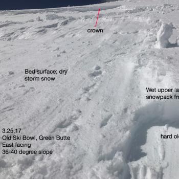
Over the past 36 hours, a storm total of 12-14 inches (.84" SWE) of new snow has fallen above 6,500 feet within the forecast area. The cold, blustery storm started on Thursday night at about 9pm and finished off yesterday by around noon. Snow levels reached down to Dunsmuir and Mt Shasta City received a few inches of snow. Observations on Gray Butte noted strong westerly winds with forays to both southwest and northwest. Shooting cracks were observed on some small, steep rollovers on Gray Butte also. The Old Ski Bowl recorded a brief albiet notable warming trend from 2pm to 6pm yesterday when temps shot from the low 20's F to 45 degrees F for a 5 hour period. We observed a couple inches of consolidation with this temperature spike, but it also created an "upside down" snowpack with wet snow on top of lighter density snow. We are not sure if this odd temperature spike initiated any natural avalanches. Sub-freezing overnight temps may have cooked up some sort of surface crust for today near and below treeline. While snowpit tests (see observation) from the Mt Shasta Ski Park were not eyebrow raising, areas that expereiced better wind loading with accompanied warm up may have seen more action. Visibility above treeline was poor yesterday and no observations were made in the alpine areas. Lingering instability is possible today, especiallly in areas exposed to wind effects near and certainly above treeline.
Weather and Current Conditions
Weather Summary
Mostly clear skies for you this morning! Winds will be light. Enjoy this brief break in the action before another system brings more precipitation and wind to the area tomorrow. Snow levels will hover near the same, about 4,000 feet for tomorrow with .5 inches of SWE forecasted...so perhaps another 4-6 inches of snow. If your going to get out this weekend, do it now!
===========================================================
In Mt Shasta City at 0500, we have a current temperature of 34 F.
On Mt Shasta (South Side) in the last 24 hours...
Sand Flat - 6,750 ft, the current temperture is 21 degrees F. Temperatures have ranged from 21 F to 32 F. Snow on the ground totals 116 inches with 6 inches of new snow and 1 inch of settlement.
Old Ski Bowl - 7,600ft. the current temperature is 18 degrees F. Temperatures have ranged from 18 F to 45 F. Snow on the ground totals 195 inches with 6 inches of new snow and 1-2inches of settlement. A storm total upwards of 13 inches has fallen over the past 36 hours
Gray Butte - 8,000 feet, the current temperature is 19 degrees F. Temperatures have ranged from 19 F to 28 F. Winds have averaged 15-20 mph with gusts to 30-40 mph, blowing from the south/southwest up until 1700 hours, then switching to west/northwest.
Mt Eddy Range (West side of Interstate-5)...
Castle Lake - 5,800 feet, the current temperature is 25 degrees F. Temperatures have ranged from 24 F to 33 F. Snow on the ground totals 102 inches with 5 inches of new snow and one inch of settlement. Storm total over the past 36 hours is about 10 inches.
Mt Eddy - 6,500 feet, the current temperature is 18 degrees F. Temperatures have ranged from 18 F to 31 F. Snow on the ground measures 98 inches with 6-8 inches of new snow and 2 inches of settlement. Winds have been southerly averaging 2 mph with gusts up to 13 mph.
THIS SEASON PRECIPITATION for MT SHASTA CITY: Since October 1st (the wet season), we have received 48.88 inches of water, normal is 34.50 inches, putting us at 141% of normal. For the month of March, we have received 5.57 inches of water, normal is 5.0 inches, which is 111% of normal. And finally for the year of 2017, we received 27.72 inches of water, normal is 19.29 inches, putting us at 143% of normal.
Always check the weather before you attempt to climb Mt Shasta. Further, monitor the weather as you climb. Becoming caught on the mountain in any type of weather can compromise life and limb. Be prepared.
| 0600 temperature: | 21 |
| Max. temperature in the last 24 hours: | 32 |
| Average wind direction during the last 24 hours: | S/SW --> W/NW |
| Average wind speed during the last 24 hours: | 15-20 mi/hr |
| Maximum wind gust in the last 24 hours: | 30-40 mi/hr |
| New snowfall in the last 24 hours: | 6 inches |
| Total snow depth: | 116 inches |
Two Day Mountain Weather Forecast
Produced in partnership with the Medford NWS
| For 7000 ft to 9000 ft | |||
|---|---|---|---|
|
Saturday (4 a.m. to 10 p.m.) |
Saturday Night (10 p.m. to 4 a.m.) |
Sunday (4 a.m. to 10 p.m.) |
|
| Weather | Isolated snow showers, otherwise mostly sunny. | Mostly cloudy. A slight chance of snow showers before 11pm, then a slight chance of snow after 11pm. | Snow. Chance of precipitation is 100%. |
| Temperature (°F) | 36 | 26 | 34 |
| Wind (mi/hr) | South/Southwest 5-10 mph | South/Southwest 5-10 mph | South/Southwest 10-15 mph |
| Precipitation SWE / Snowfall (in) | / 0 | / 0 | / 3-5 |
| For 9000 ft to 11000 ft | |||
| Saturday | Saturday Night | Sunday | |
| Weather | Isolated snow showers. Mostly sunny. Breezy. Wind chill values as low as -8. | A slight chance of snow showers before 11pm, then a slight chance of snow after 11pm. Mostly cloudy. Breezy. Wind chill values as low as -1. | Snow and windy. Wind chill values as low as -6. Chance of precipitation is 100%. |
| Temperature (°F) | 19 | 19 | 21 |
| Wind (mi/hr) | West 10-15 mph | West/Southwest 0 | West/Southwest 25-30 mph |
| Precipitation SWE / Snowfall (in) | / 0 | / 0 | / 5-7 |

