

You are here
Avalanche Advisory for 2017-03-26 06:06:52
- EXPIRED ON March 27, 2017 @ 6:06 amPublished on March 26, 2017 @ 6:06 am
- Issued by Nick Meyers - Shasta-Trinity National Forest
Bottom Line
LOW danger this morning will rise to MODERATE with brief windows of CONSIDERABLE avalanche danger today. New wind slabs are possible near and above treeline due to gusty west/southwest winds and fresh snow. Pay attention to areas where blowing snow is observed. Evaluate the snow carefully and identify features of concern.


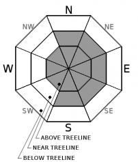
Avalanche Problem 1: Wind Slab
-
Character ?

-
Aspect/Elevation ?
-
Likelihood ?CertainVery LikelyLikelyPossible
 Unlikely
 -
Size ?HistoricVery LargeLargeSmall

Existing wind slabs are not expected to be reactive today however new wind slabs will be possible as several inches of new snow and moderate west to southwest winds impact the forecast area. The avalanche danger will be the highest immediately during or just after today's storm. If you see blowing snow or any other evidence of active wind loading, avoid those slopes. Areas near ridgelines and below cornice formations are exactly the places to avoid when wind loading is observed. This avalanche problem will be of most concern in exposed areas near treeline and above treeline.
Forecast Discussion
Existing avalanche concerns are few. For today, new wind slabs will be your primary focus, near and above treeline. Situational awareness is one of the best tools to have in the backcountry! Pay attention specifically to blowing snow today and avoid those slopes where wind loading is active.
Recent Observations
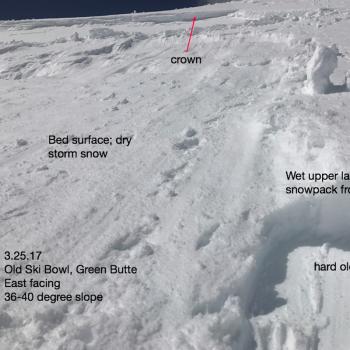
Temperatures are 5-10 degrees warmer this morning. Winds have remained westerly and light. Several inches of settlement has occurred in the snowpack. Yesterday, observations were made on the south side of Mt Shasta and a little bit of everything was seen. A natural wind slab avalanche off the north facing aspect of Green Butte, 9,000 feet, looked to have happened sometime during the most recent storm... Thursday night or Friday. A snowbike triggered wet storm slab came off an east facing aspect near Powder Bowl, approximately 8,300 feet. Roller balls simultaneously started to form on east/southeast aspects just before this avalanche occurred. Temperatures did not get extremely warm yesterday however the sun was out for at least 3/4 of the day before clouds started to filter in and the light went flat at about 2:30 to 3PM. Winds were light. Snowpit tests in the AM on an east aspect over by Grey Butte did not reveal any good looking slab over weak layer properties. About 1 to 2 feet of consolidated new snow sits well bonded to our firm, old snow. Some areas exposed to direct sunlight hosted a thin sun crust below and near treeline. Above 8,500 feet, snow surfaces began to be effected by wind texture. Widespread evidence of high winds (NW-W-SW) was easily noticable along the west aspect of Grey Butte. Generally smooth and soft snow surfaces was observed in most other areas not affected by wind. Late in the afternoon, lower elevation snow was heavy and wet. 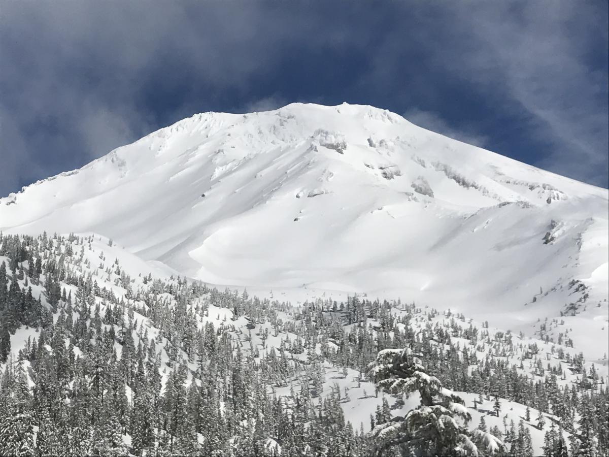
Mt Shasta, view from the southeast, 3.25.17 - Photo: Meyers
Weather and Current Conditions
Weather Summary
For the odd chance that you just havn't had enough of Winter yet, you are in luck. Yet another system brings snow to the already healthy snowpack in the higher elevations. An additional .55 inches of water is expected to fall over the forecast area today with snow levels at about 4,200 feet. This could mean another 2-5 inches of snow for the high country. South/Southwest winds will remain light to moderate below treeline but crescendo above treeline into the 20-30 mph range, southwest. This short lived storm will give way to gradual clearing Monday and a break in the action for Tuesday. A small system with light precipitation is looking likely for mid-week.
===========================================================
In Mt Shasta City at 0500, we have a current temperature of 41 F.
On Mt Shasta (South Side) in the last 24 hours...
Sand Flat - 6,750 ft, the current temperture is 30 degrees F. Temperatures have ranged from 16 F to 37 F. Snow on the ground totals 112 inches with no new snow and 4 inches of settlement.
Old Ski Bowl - 7,600ft. the current temperature is 27 degrees F. Temperatures have ranged from 18 F to 39 F. Snow on the ground totals 192 inches with no new snow and 2.5 inches of settlement.
Gray Butte - 8,000 feet, the current temperature is 24 degrees F. Temperatures have ranged from 18 F to 36 F. Winds have averaged 5-10 mph with gusts to 21 mph, blowing westerly in nature.
Mt Eddy Range (West side of Interstate-5)...
Castle Lake - 5,800 feet, the current temperature is 31 degrees F. Temperatures have ranged from 24 F to 48 F. Snow on the ground totals 100 inches with no new snow and 1.5 inches of settlement.
Mt Eddy - 6,500 feet, the current temperature is 28 degrees F. Temperatures have ranged from 17 F to 34 F. Snow on the ground measures 97 inches with no new snow and 1 inch of settlement. Winds have been southerly averaging 2 mph with gusts up to 10 mph.
THIS SEASON PRECIPITATION for MT SHASTA CITY: Since October 1st (the wet season), we have received 48.89 inches of water, normal is 34.65 inches, putting us at 141% of normal. For the month of March, we have received 5.58 inches of water, normal is 5.15 inches, which is 108% of normal. And finally for the year of 2017, we received 27.73 inches of water, normal is 19.44 inches, putting us at 142% of normal.
Always check the weather before you attempt to climb Mt Shasta. Further, monitor the weather as you climb. Becoming caught on the mountain in any type of weather can compromise life and limb. Be prepared.
| 0600 temperature: | 30 |
| Max. temperature in the last 24 hours: | 37 |
| Average wind direction during the last 24 hours: | Westerly |
| Average wind speed during the last 24 hours: | 5-10 mi/hr |
| Maximum wind gust in the last 24 hours: | 15-20 mi/hr |
| New snowfall in the last 24 hours: | 0 inches |
| Total snow depth: | 112 inches |
Two Day Mountain Weather Forecast
Produced in partnership with the Medford NWS
| For 7000 ft to 9000 ft | |||
|---|---|---|---|
|
Sunday (4 a.m. to 10 p.m.) |
Sunday Night (10 p.m. to 4 a.m.) |
Monday (4 a.m. to 10 p.m.) |
|
| Weather | Snow. Breezy. Chance of precipitation is 100%. | Snow showers. Breezy. Chance of precipitation is 90%. | Snow showers likely, mainly before 11am. Partly sunny. Chance of precipitation is 60%. |
| Temperature (°F) | 35 | 22 | 36 |
| Wind (mi/hr) | South 10-15 mph | West/Southwest 10-15 mph | West/Northwest 5-10 mph |
| Precipitation SWE / Snowfall (in) | / 2-5 | / 1-3 | / 0-1 |
| For 9000 ft to 11000 ft | |||
| Sunday | Sunday Night | Monday | |
| Weather | Snow. Wind chill values as low as -4. Windy. Chance of precipitation is 100%. | Snow showers. The snow could be heavy at times. Windy. Wind chill values as low as -16. Chance of precipitation is 90%. | Snow showers likely, mainly before 11am. Partly sunny. Windy. Wind chill values as low as -16. Chance of precipitation is 60%. |
| Temperature (°F) | 23 | 8 | 19 |
| Wind (mi/hr) | Southwest 30-40 mph | Southwest 3-6 | Northwest 20-30 mph |
| Precipitation SWE / Snowfall (in) | / 3-6 | / 2-4 | / 0-1 |

