

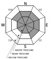
You are here
Avalanche Advisory for 2017-03-29 06:45:00
- EXPIRED ON March 30, 2017 @ 6:45 amPublished on March 29, 2017 @ 6:45 am
- Issued by Aaron Beverly - Mount Shasta Avalanche Center
Bottom Line
Avalanche danger above treeline is MODERATE due to the existence of wind slabs. Near treeline avalanche danger is LOW overall though isolated areas of MODERATE danger could exist on leeward slopes greater than 35 degrees. Cornice falls and wet loose avalanches are a secondary concern below 8500'. Below treeline, avalanche danger is LOW.


Avalanche Problem 1: Wind Slab
-
Character ?

-
Aspect/Elevation ?
-
Likelihood ?CertainVery LikelyLikelyPossible
 Unlikely
 -
Size ?HistoricVery LargeLargeSmall

Wind slab issues are likely to persist above treeline from 9000' to 12000'. The strongest winds capable of transporting snow observed during and after the storms beginning late on March 23rd, which saw snow accumulation up to 20 inches, were south, southwest, west southwest, and northwest. This could put wind slabs on north, northeast, east, and southeast aspects. But winds can be variable particularly at high elevations and cross loading can occur, so stay alert on all aspects if you find yourself above 9000' today. Wind slabs near treeline are less likely to exist due to stablizing conditions over the last couple of days, but they could still exist in isolated areas from 8000 to 8500'. Most evidence of wind loading near treeline has occured on east and northeast aspects.
A few inches of new snow is expected tonight above 9000'. This coupled with strong winds, could see the creation of shallow isolated slabs on leeward aspects by tomorrow morning.
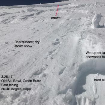
A small avalanche was observed near red banks by some climbers camped near Helen Lake. Climbers were observed near Red Banks. It is unclear if this slide was human triggered or natural. If you are ascending today, remember wind slabs could exists on all aspects below Red Banks. Scoured conditions may also exist making ice axe and crampon skills essential for those climbing above Helen Lake.
A wind slab is a cohesive layer of snow formed when wind deposits snow onto leeward terrain. Wind slabs are often smooth and rounded and sometimes sound hollow. Look for shooting cracks in the snow as an indicator of this avalanche problem.
Forecast Discussion
A widespread wind crust was seen on rigdelines and in bowls and gulleys yesterday from 8000' to at least 9000'. Wind crust was moist and likely re-froze over night further locking the snow pack. No propagating failures were produced in snow pit tests. Overall, the avalanche danger near treeline is LOW, though isolated areas of MODERATE danger could exist where wind loading has occurred. This will mostly be on easterly and northeasterly aspects near treeline. With above freezing temperatures up to 8500' and some rain predicted today, these slabs could become more sensitive to trigger over the next 24 hours.
A few roller balls and a cornice breaks were observed yesterday and with warmer temperatures today, secondary concerns will be loose wet slides and cornices falls below 8500'. If your boots are sinking up to their cuffs or further, stay clear of slopes greater than 35 degrees. If you are traveling near cornices, make sure you are above terra firma.
With snow levels increasing to 8500' today and tonight, and rain expected, today may be a day to stay home and rest up for the weekend when a return to spring ski conditions is likely.
Recent Observations
A surprising amount of skiers ventured out yesterday in search decent snow conditions. None reported finding any. The snow pack below and near treeline showed all the signs of a snow pack in transition. Moist to wet snow, 3-12 inches deep, breakable crusts, supportable crusts, and moist but firm wind crusts above 8000'. Scoured conditions were seen and reported on ridgelines and in bowls and gulleys above Bunny Flat up to at least 9000'.
If you are still looking for good snow, expect to find it mostly on easterly aspects and above 9000'. Snow below 9000' is either blown away or affected by the warmer weather and sun exposure. The storms starting late on March 23 that brought up to 20 inches of snow were accompanied and followed by strong south, southwest, west, and northwest winds as measured by the Grey Butte weather station. Evidence of this was seen above 8000' on Green Butte ridge. Sastrugis indicate that most wind effect came from southwest winds.
Climbers that camped just below Helen lake reported mostly scoured conditions and saw a small avalanche near the Heart below Red Banks indicating that a wind slab problem could still exist at high elevations.
A few roller balls were observed up to 8500'. Though visibility was low, it appeared a cornice broke at the top of Sun Bowl yesterday afternoon. Small cornices along Green Butte ridge broke with a few hard ski stomps.
No loose dry snow was available for transport below 8500' and reports from climbers indicate that little is available up to 10,000'
On an easterly aspect of lower Sun Bowl at about 8300', CTM12 Q2 failures were seen below new wind effected snow near a melt-freeze crust, 28 cm down. No propagation failures were seen in ECT tests.
Weather and Current Conditions
Weather Summary
The effects of a high pressure ridge off the coast and extending inland will continue today and tomorrow. A cold front will move into the area today, bringing with it high snow levels and rain. We may get up to .33 inches of precipitation out of this with the most intense precipitation between 5 p.m and 5 a.m tonight. Snow levels will rise today and tonight to 8500' and then return to 5000' tomorrow.
Warmer, drier air will follow bringing spring-like conditions starting Friday and extending into early next week.
In Mt Shasta City at 0500, we have a current temperature of 38 F.
On Mt Shasta (South Side) in the last 24 hours...
Sand Flat - 6,750 ft, the current temperture is 37 degrees F. Temperatures have ranged from 26 F to 40 F. Snow on the ground totals 111 inches with no new snow and 2 inches of settlement.
Old Ski Bowl - 7,600ft. the current temperature is 40.3 degrees F. Temperatures have ranged from 22 F to 40 F. Snow on the ground totals 195 inches with no new snow and 1.4 inches of settlement.
Gray Butte - 8,000 feet, the current temperature is 35 degrees F. Temperatures have ranged from 29 F to 35 F. Winds have ranged from 1-18 mph with gusts to 28 mph, blowing mostly from the east southeast, but switching to northwest early this morning.
Mt Eddy Range (West side of Interstate-5)...
Castle Lake - 5,800 feet, the current temperature is 39 degrees F. Temperatures have ranged from 39 F to 42 F. Snow on the ground totals 100 inches with no new snow an inch of settlement.
Mt Eddy - 6,500 feet, the current temperature is 36 degrees F. Temperatures have ranged from 36 F to 41 F. Snow on the ground measures 96 inches with no new snow and 3 inches of settlement. Winds have averaged 2 mph with gusts up to 20 mph, blowing mostly out of the southeast but switching to west southwest late last night.
THIS SEASON PRECIPITATION for MT SHASTA CITY: Since October 1st (the wet season), we have received 49.15 inches of water, normal is 35.07 inches, putting us at 140% of normal. For the month of March, we have received 5.84 inches of water, normal is 5.57 inches, which is 105% of normal. And finally for the year of 2017, we received 27.99 inches of water, normal is 19.86 inches, putting us at 141% of normal.
Always check the weather before you attempt to climb Mt Shasta. Further, monitor the weather as you climb. Becoming caught on the mountain in any type of weather can compromise life and limb. Be prepared.
| 0600 temperature: | 37 |
| Max. temperature in the last 24 hours: | 40 |
| Average wind direction during the last 24 hours: | ESE shifting NW |
| Average wind speed during the last 24 hours: | 1-18 mi/hr |
| Maximum wind gust in the last 24 hours: | 28 mi/hr |
| New snowfall in the last 24 hours: | 0 inches |
| Total snow depth: | 111 inches |
Two Day Mountain Weather Forecast
Produced in partnership with the Medford NWS
| For 7000 ft to 9000 ft | |||
|---|---|---|---|
|
Wednesday (4 a.m. to 10 p.m.) |
Wednesday Night (10 p.m. to 4 a.m.) |
Thursday (4 a.m. to 10 p.m.) |
|
| Weather | Rain likely after 11am. Mostly cloudy. Chance of precipitation is 70%. | Rain before 11pm, then showers likely after 11pm. Breezy. Chance of precipitation is 90%. | Snow showers likely, mainly before 11am. Partly sunny. Chance of precipitation is 70%. |
| Temperature (°F) | 50 | 30 | 37 |
| Wind (mi/hr) | Southwest 15-25 mph | Northwest 20-15 mph | Northwest 15-20 mph |
| Precipitation SWE / Snowfall (in) | / 0 | / 0 | / <1 |
| For 9000 ft to 11000 ft | |||
| Wednesday | Wednesday Night | Thursday | |
| Weather | Snow after 11am. Windy. Chance of precipitation is 80%. | Snow before 11pm, then snow showers likely after 11pm. Windy. Chance of precipitation is 90%. | Snow showers likely, mainly before 11am. Mostly cloudy, then gradually becoming sunny. Windy. Chance of precipitation is 70%. |
| Temperature (°F) | 28 | 11 | 13 |
| Wind (mi/hr) | West 25-50 mph | West then Northwest 1-2 | North 25-35 mph |
| Precipitation SWE / Snowfall (in) | / 1-2 | / 2-4 | / <1 |

