

You are here
Avalanche Advisory for 2017-03-30 06:30:00
- EXPIRED ON March 31, 2017 @ 6:30 amPublished on March 30, 2017 @ 6:30 am
- Issued by Aaron Beverly - Mount Shasta Avalanche Center
Bottom Line
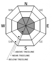
Avalanche danger above treeline is MODERATE due to the potential for wind slab avalanches. Wind slabs may exist on all aspects above 9000' and are a concern on slopes greater than 35 degrees. Near and below treeline, avalanche danger is LOW.


Avalanche Problem 1: Wind Slab
-
Character ?

-
Aspect/Elevation ?
-
Likelihood ?CertainVery LikelyLikelyPossible
 Unlikely
 -
Size ?HistoricVery LargeLargeSmall

Old wind slabs may persist above 9000' today on all aspects. With plenty of settlement in the snowpack, these are becoming less of a concern, but check the snowpack if you are ascending high into the alpine today where your route takes you into terrain greater than 35 degrees. Are the slabs well bonded with the surface snow beneath?
New shallow wind slabs may have formed last night in isolated areas above 9000'. These are unlikely to be dangerous, but unlikely does not mean impossible. Evaluate conditions as you ascend. A small avalanche above a terrain trap increases the consequences of getting caught in a slide.
Forecast Discussion
Yesterday was a warm wet day with snow levels near 8500'. With snow levels dropping to 4000' this morning, the snow pack should become locked up tight with a surface rain / melt-freeze crust. This eliminates concerns for wind slabs or wet loose slides near and below treeline. Snow will likely be hard and fast, so if you venture out skiing today, sharpen those edges!
With only 0.2 inches of water received at lower elevations, it is unlikely this translated into much snow above treeline and strong and gusty winds may have blown most of it away. Some new shallow wind slabs may have formed in isolated areas.
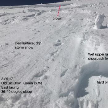
The main concern above treeline remains old slabs formed by the March 23rd and March 26th storms that produced up to 20 inches of snow. The snow pack at 7600' has gone through 9 inches of settlement since March 26th so wind slabs concerns are diminishing above treeline, but if you ascend above 9000' today, you should evaluate the stability of wind loaded areas on slopes greater than 35 degrees.
Recent Observations
Warm, wet, and sticky conditions were seen yesterday at Horse Camp. Weather stations reported highs of 45 F at 7600' and 54 F at 5800'. About 0.2 inches of rain was received in the Old Ski Bowl. Temperatures during the period of precipitation were in the mid-30's at 8000'.
Weather and Current Conditions
Weather Summary
Snow levels will drop today and tonight to around 4000' as the tail end of cold front passes through. Expect clearing conditions throughout the day. Tomorrow freezing levels will jump back up to near 10,000' by early afternoon. Enjoy the warm clear conditions Friday and Saturday and then get ready for more unsettled weather Sunday.
-------------------------------------------------------------------------------
In Mt Shasta City at 0500, we have a current temperature of 38 F
On Mt Shasta (South Side) in the last 24 hours...
Sand Flat - 6,750 ft, the current temperture is 29 degrees F. Temperatures have ranged from 29 F to 46 F. Snow on the ground totals 109 inches with no new snow and 1 inch of settlement.
Old Ski Bowl - 7,600ft. the current temperature is 29 degrees F. Temperatures have ranged from 29 F to 44 F. Snow on the ground totals 191 inches with no new snow and 3 inches of settlement. Rain received was 0.2 inches.
Gray Butte - 8,000 feet, the current temperature is 26 degrees F. Temperatures have ranged from 26 F to 40 F. Winds have averaged 24 mph with gusts to 49 mph, blowing mostly from the northwest.
Mt Eddy Range (West side of Interstate-5)...
Castle Lake - 5,800 feet, the current temperature is 30 degrees F. Temperatures have ranged from 30 F to 54 F. Snow on the ground totals 97 inches with no new snow and 3 inches of settlement.
Mt Eddy - 6,500 feet, the current temperature is 27 degrees F. Temperatures have ranged from 33 F to 48 F. Snow on the ground measures 94 inches with no new snow and 2 inches of settlement. Winds have averaged 2 mph with gusts up to 12 mph, blowing out of the south and southwest.
THIS SEASON PRECIPITATION for MT SHASTA CITY: Since October 1st (the wet season), we have received 49.32 inches of water, normal is 35.20 inches, putting us at 140% of normal. For the month of March, we have received 6.01 inches of water, normal is 5.70 inches, which is 105% of normal. And finally for the year of 2017, we received 28.16 inches of water, normal is 19.99 inches, putting us at 141% of normal.
Always check the weather before you attempt to climb Mt Shasta. Further, monitor the weather as you climb. Becoming caught on the mountain in any type of weather can compromise life and limb. Be prepared.
| 0600 temperature: | 29 |
| Max. temperature in the last 24 hours: | 44 |
| Average wind direction during the last 24 hours: | Northwest |
| Average wind speed during the last 24 hours: | 24 mi/hr |
| Maximum wind gust in the last 24 hours: | 49 mi/hr |
| New snowfall in the last 24 hours: | 0 inches |
| Total snow depth: | 191 inches |
Two Day Mountain Weather Forecast
Produced in partnership with the Medford NWS
| For 7000 ft to 9000 ft | |||
|---|---|---|---|
|
Thursday (4 a.m. to 10 p.m.) |
Thursday Night (10 p.m. to 4 a.m.) |
Friday (4 a.m. to 10 p.m.) |
|
| Weather | A 30 percent chance of snow showers. Mostly cloudy, then gradually becoming sunny. | Mostly clear. Blustery. | Sunny. |
| Temperature (°F) | 37 | 25 | 53 |
| Wind (mi/hr) | Northwest 21-28 mph | North 20-28 mph | North 14-20 mph |
| Precipitation SWE / Snowfall (in) | / trace | / 0 | / 0 |
| For 9000 ft to 11000 ft | |||
| Thursday | Thursday Night | Friday | |
| Weather | A 30 percent chance of snow showers. Mostly cloudy, then gradually becoming sunny. | Mostly clear. | Sunny. |
| Temperature (°F) | 18 | 18 | 34 |
| Wind (mi/hr) | North Northwest 38-50 mph | North trace | North 42-47 mph |
| Precipitation SWE / Snowfall (in) | / trace | / 0 | / 0 |

