

You are here
Avalanche Advisory for 2017-03-31 06:30:00
- EXPIRED ON April 1, 2017 @ 6:30 amPublished on March 31, 2017 @ 6:30 am
- Issued by Aaron Beverly - Mount Shasta Avalanche Center
Bottom Line
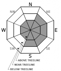
Avalanche danger near and above treeline is MODERATE due to the formation of new wind slabs. Near treeline, expect wind slabs on east and southeast aspects. Above treeline, slabs may exist on all aspects. Slopes greater than 35 degrees are most prone to avalanche. Below treeline, avalanche danger is LOW.


Avalanche Problem 1: Wind Slab
-
Character ?

-
Aspect/Elevation ?
-
Likelihood ?CertainVery LikelyLikelyPossible
 Unlikely
 -
Size ?HistoricVery LargeLargeSmall

New wind slabs on east and southeast aspects are the primary concern today near treeline. Three inches of new snow coupled with strong west and northwest winds have created wind slabs 4-6 inches thick. Weak bonding with an underlying rain crust could make these slabs sensitive to human trigger. Above treeline, wind slabs may exist on all aspects. If venturing onto terrain greater than 35 degrees today, evaluate the snow pack carefully to determine the presence of this avalanche problem.
Forecast Discussion
Yesterday's snow accumulation on Mount Shasta was unexpected. Close to 3 inches of snow was received at Sand Flat mostly between 8 a.m and 1 p.m. Sustained winds were optimal for snow transport leading to the formation of wind slabs up to 6 inches.
With warming temperatures today and tomorrow, loose wet avalanches may become an issue. These slides begin at a point and entrain snow as they move downhill. They generally are not dangerous, but they could sweep a skier into undesirable terrain. Rollerballs on sun exposed slopes are indicators of the existence of this problem.
Powder skiing should still be good in wind protected areas (easterly aspects and areas with a lot of trees). Expect ridgelines, wide open areas, and westerly aspects to be scoured today. Temperatures will be warming quickly this morning, and the sun will be out, so if you are gonna get it, get at it early.
Recent Observations
Though the forecast called for a trace of snow Thursday, 2-3 inches was received yesterday above 5000' on Mount Shasta. Strong winds (average: 33 mph, maximum sustained: 60 mph) were transporting snow onto eastern and southeastern aspects and into gulleys near treeline (see video below). Ridges and westerly aspects were becoming scoured. Scouring was also occuring in wide open areas without much wind protection from trees.
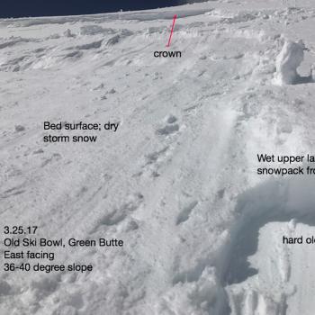
New snow was a dry mix of graupel (PPgp) and wind broken fragmented precipitation particles (DFbk). There was a widespread rain crust and new snow bonding to it was weak. Wind slabs were forming from 4-6 inches thick. These were easy to trigger in tree wells and on rollovers though very little propagation was seen (see image below).
Skiing was quite good on easterly aspects and in wind protected areas below treeline.
Video of Wind Transport Near Lower Sunbowl.

Weather and Current Conditions
Weather Summary
A high pressure ridge will bring warmer dryer weather today. Snow levels will quickly rise this morning to 7000' and then 9500' tonight. There is a slight chance of rain on Sunday, but overall the next several days should see a return to melt-freeze cycles and the possibility of corn skiing. Expect several days of precipitation starting Wednesday of next week.
In Mt Shasta City at 0500, we have a current temperature of 34 F
On Mt Shasta (South Side) in the last 24 hours...
Sand Flat - 6,750 ft, the current temperture is 18 degrees F. Temperatures have ranged from 18 F to 29 F. Snow on the ground totals 112 inches with 3 inches of new snow and 1/2 inch of settlement.
Old Ski Bowl - 7,600ft. This weather station is down. We apologize for the inconvenience.
Grey Butte - 8,000 feet, the current temperature is 19 degrees F. Temperatures have ranged from 17 F to 34 F. Winds have averaged 33 mph with gusts to 60 mph, blowing mostly from the northwest.
Mt Eddy Range (West side of Interstate-5)...
Castle Lake - 5,800 feet, the current temperature is 23 degrees F. Temperatures have ranged from 23 F to 30 F. Snow on the ground totals 99 inches with 2 inches of new.
Mt Eddy - 6,500 feet, the current temperature is 18 degrees F. Temperatures have ranged from 18 F to 27 F. Snow on the ground measures 93 inches with no new snow and 1 inch of settlement. Winds have averaged 5 mph with gusts up to 25 mph, blowing out of the southeast.
THIS SEASON PRECIPITATION for MT SHASTA CITY: Since October 1st (the wet season), we have received 49.46 inches of water, normal is 35.33 inches, putting us at 140% of normal. For the month of March, we have received 6.15 inches of water, normal is 5.83 inches, which is 105% of normal. And finally for the year of 2017, we received 28.30 inches of water, normal is 20.12 inches, putting us at 141% of normal.
Always check the weather before you attempt to climb Mt Shasta. Further, monitor the weather as you climb. Becoming caught on the mountain in any type of weather can compromise life and limb. Be prepared.
| 0600 temperature: | 18 |
| Max. temperature in the last 24 hours: | 29 |
| Average wind direction during the last 24 hours: | Northwest |
| Average wind speed during the last 24 hours: | 33 mi/hr |
| Maximum wind gust in the last 24 hours: | 60 mi/hr |
| New snowfall in the last 24 hours: | 3 inches |
| Total snow depth: | 112 inches |
Two Day Mountain Weather Forecast
Produced in partnership with the Medford NWS
| For 7000 ft to 9000 ft | |||
|---|---|---|---|
|
Friday (4 a.m. to 10 p.m.) |
Friday Night (10 p.m. to 4 a.m.) |
Saturday (4 a.m. to 10 p.m.) |
|
| Weather | Sunny. Windy. | Mostly clear. Breezy. | Mostly sunny. |
| Temperature (°F) | 41 | 34 | 49 |
| Wind (mi/hr) | North 18-25 mph | North 5-23 mph | Northwest 11-17 mph |
| Precipitation SWE / Snowfall (in) | / 0 | / 0 | / 0 |
| For 9000 ft to 11000 ft | |||
| Friday | Friday Night | Saturday | |
| Weather | Sunny. Windy. | Mostly clear. Windy. | Sunny. |
| Temperature (°F) | 33 | 28 | 40 |
| Wind (mi/hr) | North 46-57 mph | North 0 | North 18-29 mph |
| Precipitation SWE / Snowfall (in) | / 0 | / 0 | / 0 |

