

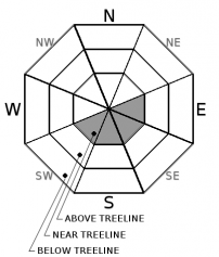
You are here
Avalanche Advisory for 2017-12-05 07:00:13
- EXPIRED ON December 6, 2017 @ 7:00 amPublished on December 5, 2017 @ 7:00 am
- Issued by Andrew Kiefer - Mt Shasta Avalanche Center
Bottom Line
The avalanche danger is LOW at all elevations throughout the advisory area. Small wind slabs may exist in isolated areas above treeline on Mount Shasta. Natural and human triggered avalanches are unlikely. Be sure to monitor changing snow surface conditions as temperatures rapidly warm up today.


Avalanche Problem 1: Wind Slab
-
Character ?

-
Aspect/Elevation ?
-
Likelihood ?CertainVery LikelyLikelyPossible
 Unlikely
 -
Size ?HistoricVery LargeLargeSmall

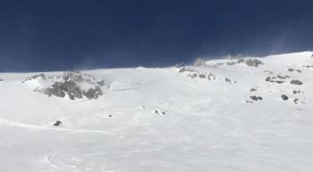
An isolated wind slab problem lingers in high alpine areas on Mount Shasta. Wind slabs 1-2ft thick on E-SE-S-SW aspects above treeline are the primary avalanche concern. Natural and human triggered wind slab avalanches are unlikely. Any wind slab avalanche that could occur would most likely be small in size. Just below ridgelines and on unsupported convex slopes 35 degrees and steeper are the most likely places where a person could trigger a wind slab today.
Forecast Discussion
An unusually warm and dry spell will begin today. Clear skies and sunshine will allow for the first rapid warm up since our recent storm ended Sunday morning. A diurnal cycle of warm days and cool nights is expected through the week with freezing levels climbing to 10,000ft by tomorrow. Get ready for an early season drought – this weather pattern looks to continue for the next 1-2 weeks.
Natural and human triggered avalanches large enough to bury, injure or kill a person are unlikely to occur in the backcountry right now. LOW danger definitely does not mean no danger, though. Continue to watch for wind slabs in leeward terrain 8,000ft and higher on Mount Shasta. Also be sure to pay attention to the rapid warm up. The sun will definitely be affecting snow surfaces today and throughout the week. Roller balls, pinwheels, and wet snow are great indications that the surface of the snowpack is loosing strength. If these signs are present, wet loose avalanches could occur.
Recent Observations
North/Northeast winds battered the advisory area yesterday. Wind transport of snow was continuous throughout the day in upper elevation alpine areas and along ridgelines on Mount Shasta. Steady wind speeds of 25-35 mph occurred at 8,000ft and above. Overnight, wind speeds dropped off significantly, and have become variable in direction. Snow surfaces have remained cold and dry despite the recent clear and sunny weather. Many areas near and above treeline have already been scoured down to rock hard and extremely icy old snow surfaces. 7,000ft and above on Mount Shasta is where a useable snowpack exists in our advisory area. The Castle Lake and Mount Eddy zones have very little snow cover.

Weather and Current Conditions
Weather Summary
An upper level ridge of high pressure has set up over the west coast bringing clear and sunny weather today. Daytime temperatures will rise to the mid 40’s at the 6,000ft level. Overnight lows should be cool and remain below freezing throughout the week. Valley temperature inversions are likely to continue. Wind speeds will drop off significantly today and easterly winds are expected.
=============================================================================
THIS SEASON PRECIPITATION for MT SHASTA CITY: Since October 1st (the wet season), we have received 5.72 inches of water, normal is 8.26 inches, putting us at 69% of normal. For the month of December, we received .18 inches of water, normal is .90 inches, which is 20% of normal. And finally for the year of 2017, we received 44.71 inches of water, normal is 36.26 inches, putting us at 123% of normal.
In Mt Shasta City at 0500, we have a current temperature of 22 F
On Mt Shasta (South Side) in the last 24 hours...
Sand Flat - 6,750 ft, the current temperature is 21 degrees F. Temperatures have ranged from 19 F to 30 F. Snow on the ground totals 14 inches with no new snow and little settlement.
Old Ski Bowl - 7,600ft, the current temperature is 30 degrees F. Temperatures have ranged from 29 F to 39 F. Snow on the ground totals 18 inches with no new snow.
Grey Butte - 8,000 feet, the current temperature is 32 degrees F. Temperatures have ranged from 30 F to 38 F. Winds have averaged 25-35 mph with gusts to 56 mph, blowing from the north/northeast.
Mt Eddy Range (West side of Interstate-5)...
Castle Lake - 5,800 feet, the current temperature is 31 degrees F. Temperatures have ranged from 19 F to 31 F. Snow depths are not reading accurrately at this time, but are minimal at this station.
Mt Eddy - 6,500 feet, the current temperature 31 degrees F. Temperatures have ranged from 22 F to 35 F. Snow on the ground measures 10 inches with no new snow and 2 inches of settlement. Winds have averaged 3-5 mph with gusts to 16 mph blowing out of the west/southwest.
Always check the weather before you attempt to climb Mt Shasta. Further, monitor the weather as you climb. Becoming caught on the mountain in any type of weather can compromise life and limb. Be prepared.
| 0600 temperature: | 16 |
| Max. temperature in the last 24 hours: | 23 |
| Average wind direction during the last 24 hours: | West/Northwest |
| Average wind speed during the last 24 hours: | 15-30 mi/hr |
| Maximum wind gust in the last 24 hours: | 64 mi/hr |
| New snowfall in the last 24 hours: | 0 inches |
| Total snow depth: | 15 inches |
Two Day Mountain Weather Forecast
Produced in partnership with the Medford NWS
| For 7000 ft to 9000 ft | |||
|---|---|---|---|
|
Tuesday (4 a.m. to 10 p.m.) |
Tuesday Night (10 p.m. to 4 a.m.) |
Wednesday (4 a.m. to 10 p.m.) |
|
| Weather | Sunny | Clear | Sunny |
| Temperature (°F) | 45 | 28 | 45 |
| Wind (mi/hr) | East/Northeast 8-10 | East 7-9 | East 7 |
| Precipitation SWE / Snowfall (in) | / 0 | / 0 | / 0 |
| For 9000 ft to 11000 ft | |||
| Tuesday | Tuesday Night | Wednesday | |
| Weather | Sunny & Breezy | Clear & Breezy | Sunny & Breezy |
| Temperature (°F) | 34 | 34 | 35 |
| Wind (mi/hr) | North/Northeast 21-36 mph, gusting 40 mph | North/Northeast 0 | East/Northeast 23-25 mph, gusting 38 mph |
| Precipitation SWE / Snowfall (in) | / 0 | / 0 | / 0 |

