

You are here
Avalanche Advisory for 2017-12-07 06:30:40
- EXPIRED ON December 8, 2017 @ 6:30 amPublished on December 7, 2017 @ 6:30 am
- Issued by Nick Meyers - Shasta-Trinity National Forest
Bottom Line
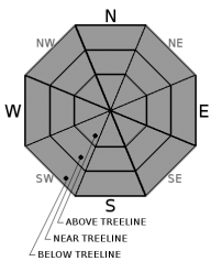
Today, Mt Shasta hosts low avalanche danger. Normal caution is advised. Watch out for sudden patches of icy snow surfaces. Self arrest could be difficult and a slide for life possible. Isolated small, hard wind slabs exist near and above treeline and will be difficult to trigger.


Avalanche Problem 1: Normal Caution
-
Character ?

-
Aspect/Elevation ?
-
Likelihood ?CertainVery LikelyLikelyPossible
 Unlikely
 -
Size ?HistoricVery LargeLargeSmall

Overall, normal caution is advised on Mt Shasta. Keep your eyes peeled for small, hard wind slabs dotting the landscape on southerly and westerly slopes near and above treeline. These slabs rest on older, firm snow. Triggering these wind slabs will be difficult due to strength of the slab.
Forecast Discussion
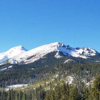
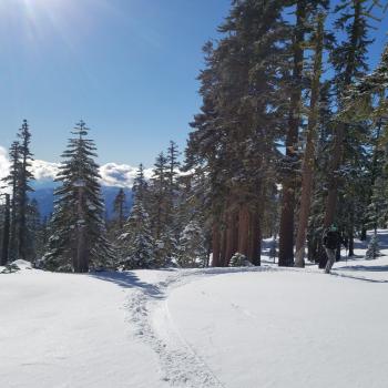
Windy conditions experienced yesterday will diminish today. Sliders and riders have been finding some corn like, soft snow in select areas on the south side of Mt Shasta at elevations below 10,000 feet. These decent snow sliding surfaces will likely get even better with sunny skies and light winds today. That said, rocks lurking below the surface are the main concern, especially on lower elevation, sun warmed slopes.
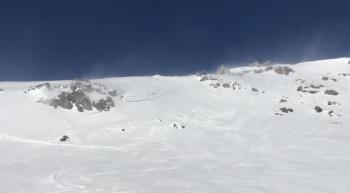
In terms of avalanches, it's going to be very difficult to find and/or trigger a slide that threatens human life today. Of highest concern is slipping and falling on our upper elevation hard, icy surfaces and taking a slide for life down the slope below.
Recent Observations
Steady, howling northeasterly winds battered forecasters yesterday during a couple hours of Old Ski Bowl (Mt Shasta) weather station improvements. Winds have scoured much of the mountain to old snow. Prominent ridgelines remain mostly rock. Twenty degree temperature inversions from town to mountain continue this morning. If there was ever a smorgasbord of conditions, it is now.
*Firm, icy and bombproof old snow
*Corn like strips of softer snow on southerly slopes unaffected by wind
*Wind slab "scabs", small with random distribution
*Cold, soft powder stashes
*Low tide, early season snowpack - rocks, trees, shrubs, punji sticks and snaggletooths
Mt Eddy and Castle Lake do not have enough snow for winter recreation. Sand Flat hosts a thin snowpack barely usable for cross country skiing. Pilgrim Creek snowmobile park has a thin layer of snow, but any snow machine fun will require several more miles of travel up Military Pass road. Off piste riding is not in yet for sledders on the east side.

Weather and Current Conditions
Weather Summary
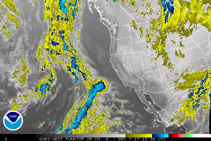
Well isn't that image something? Sunny California is certainly living up to its name this month. But it's not Summer. What the heck? Life has a lot of lessons to offer and I think we can agree one of them is to be resilient. Resilient high pressure ridges or resilient from that life lemon you were dished, we've got to withstand these difficult times by keeping our heads up and pores open. Spiritual guru's tell us to live in the now and right now (and the near future) this weather pattern will be playing house. Inversions will be for breakfast, light winds for lunch and alpenglow for dinner. Bon appetit!
-------------------------
THIS SEASON PRECIPITATION for MT SHASTA CITY: Since October 1st (the wet season), we have received 5.72 inches of water, normal is 8.73 inches, putting us at 65% of normal. For the month of December, we have received .18 inches of water, normal is 1.37 inches, which is 13% of normal. And finally for the year of 2017, we received 44.71 inches of water, normal is 36.73 inches, putting us at 121% of normal.
Always check the weather before you attempt to climb Mt Shasta. Further, monitor the weather as you climb. Becoming caught on the mountain in any type of weather can compromise life and limb. Be prepared.
24 Hour Weather Station Data @
| Weather Station | Temp (°F) | Wind (mi/hr) | Snow (in) | Comments | ||||||||
|---|---|---|---|---|---|---|---|---|---|---|---|---|
| Cur | Min | Max | Avg | Avg | Max Gust | Dir | Depth | New | Water Equivalent | Settlement | ||
| Mt. Shasta City (3540 ft) | 23 | 23 | 48 | |||||||||
| Sand Flat (6750 ft) | 44 | 26 | 47 | 37.8 | 14.8 | 0 | 0 | 0 | ||||
| Ski Bowl (7600 ft) | 43 | 37 | 45 | 41 | 17.9 | 0 | 0 | 0 | ||||
| Gray Butte (8000 ft) | 42 | 36 | 42 | 39 | 29 | 55 | NE | |||||
| Castle Lake (5870 ft) | 37 | 31 | 42 | 37 | 4 | |||||||
| Mount Eddy (6509 ft) | 36 | 33 | 43 | 37 | 2 | 13 | WSW | 11 | ||||
| Ash Creek Bowl (7250 ft) | Station Down | |||||||||||
| Ash Creek Ridge (7895 ft) | Station Down |
Two Day Mountain Weather Forecast
Produced in partnership with the Medford NWS
| For 7000 ft to 9000 ft | |||
|---|---|---|---|
|
Thursday (4 a.m. to 10 p.m.) |
Thursday Night (10 p.m. to 4 a.m.) |
Friday (4 a.m. to 10 p.m.) |
|
| Weather | Sunny | Clear | Sunny |
| Temperature (°F) | 51 | 35 | 47 |
| Wind (mi/hr) | East/Southeast 5-10 | East/Southeast 5-10 | Southeast 0-5 |
| Precipitation SWE / Snowfall (in) | / 0 | / 0 | / 0 |
| For 9000 ft to 11000 ft | |||
| Thursday | Thursday Night | Friday | |
| Weather | Sunny | Clear | Sunny |
| Temperature (°F) | 35 | 34 | 35 |
| Wind (mi/hr) | Southeast 5-10 | South/Southeast 0 | South/Southeast 5-10 |
| Precipitation SWE / Snowfall (in) | / 0 | / 0 | / 0 |

