

You are here
Avalanche Advisory for 2017-12-08 05:57:39
- EXPIRED ON December 9, 2017 @ 5:57 amPublished on December 8, 2017 @ 5:57 am
- Issued by Nick Meyers - Shasta-Trinity National Forest
Bottom Line
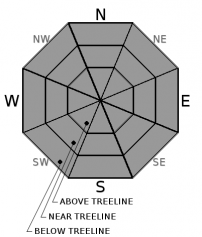
The avalanche danger is LOW at all elevations and aspects today. Extra caution is warranted when traveling in exposed, steep terrain with high consequences where typically small and benign avalanches pose a significant hazard.
Watch out for sudden patches of icy snow surfaces on the upper mountain. Self arrest could be difficult and a slide for life possible.


Avalanche Problem 1: Normal Caution
-
Character ?

-
Aspect/Elevation ?
-
Likelihood ?CertainVery LikelyLikelyPossible
 Unlikely
 -
Size ?HistoricVery LargeLargeSmall

Normal caution is advised today. Isolated slabs are generally related to wind and terrain: look for places where small areas of drifting have occurred and firm layers of surface snow overlie softer layers. Often this will occur on the lee side of ridges, in terrain depressions, on convex terrain features, and in the lee of isolated bands of trees.
Forecast Discussion
Go buy a lottery scratcher...your chances of winning are better than triggering or observing an avalanche today. Our advisories are going to get increasingly wierd by the day as we endure this early season drought. Climate prediction models are not making us smile. Stay strong Mt Shasta.
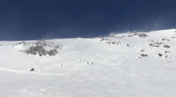
The clear December weather might entice a few climbers to give the mountain a go. Continue to be aware of the firm snow conditions that will lend to a slide for life without quick self arrest. In some areas self arrest may be impossible. Many rocks protrude from the snowpack increasing the consequences of a fall. Rockfall has been low, but don't write it off. Rime ice is plastered on Redbanks and other exposed rocks. These rime ice formations could flake off and act like falling rock. Wear a helmet. Pay attention and have good mountain sense.
With limited terrain available for riding (low tide as some call it), take the time to practice with your rescue gear if you get out.
If you have not seen this video, check it out: TO HELL IN A HEARTBEAT
Recent Observations
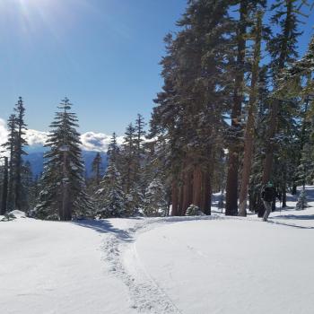
Strong inversions again today. Overnight lows on the mountain did not reach freezing. Freezing levels have been near 10 to 11,000 feet. Winds calmed a bit yesterday afternoon but have picked up last night and this morning out of the east. Snow surface conditions continue to stay the same. Some have reported some decent skiing, considering the conditions, in select areas on the south side.
*Firm, icy and bombproof old snow
*Corn like strips of softer snow on southerly slopes unaffected by wind
*Wind slab "scabs", small with random distribution
*Cold, soft "powder" stashes
*Low tide, early season snowpack - rocks, trees, shrubs, punji sticks and snaggletooths
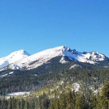
Mt Eddy and Castle Lake do not have enough snow for winter recreation. Sand Flat hosts a thin snowpack barely usable for cross country skiing. Pilgrim Creek snowmobile park has a thin layer of snow, but any snow machine fun will require several more miles of travel up Military Pass road. Off piste riding is not in yet for sledders on the east side.

Weather and Current Conditions
Weather Summary
Yesterdays word of the day was resilient. Todays word is persistence. A strong blocking ridge anchored along the West Coast will continue to play house through the weekend and much of next week. This will bring dry air over the upper slopes, continued inversions and light winds. Late next week is the earliest that this pattern has a chance of breaking up. Even then, a significant storm system is not expected.
-----------------------------------------------------------
THIS SEASON PRECIPITATION for MT SHASTA CITY: Since October 1st (the wet season), we have received 5.72 inches of water, normal is 8.97 inches, putting us at 63% of normal. For the month of December, we have received .18 inches of water, normal is 1.61 inches, which is 11% of normal. And finally for the year of 2017, we received 44.71 inches of water, normal is 36.97 inches, putting us at 120% of normal.
Always check the weather before you attempt to climb Mt Shasta. Further, monitor the weather as you climb. Becoming caught on the mountain in any type of weather can compromise life and limb. Be prepared.
24 Hour Weather Station Data @
| Weather Station | Temp (°F) | Wind (mi/hr) | Snow (in) | Comments | ||||||||
|---|---|---|---|---|---|---|---|---|---|---|---|---|
| Cur | Min | Max | Avg | Avg | Max Gust | Dir | Depth | New | Water Equivalent | Settlement | ||
| Mt. Shasta City (3540 ft) | 28 | 22 | 51 | 33 | NNE | |||||||
| Sand Flat (6750 ft) | 43 | 36 | 52 | 44 | 14 | 0 | 0 | 0 | ||||
| Ski Bowl (7600 ft) | 44 | 42 | 50 | 45 | 18 | 0 | 0 | 0 | ||||
| Gray Butte (8000 ft) | 43 | 42 | 51 | 45 | 16 | 36 | NE | |||||
| Castle Lake (5870 ft) | 43 | 39 | 49 | 44 | 0 | |||||||
| Mount Eddy (6509 ft) | 38 | 34 | 50 | 40 | 2 | 6 | WSW | 11 | ||||
| Ash Creek Bowl (7250 ft) | Station Down | |||||||||||
| Ash Creek Ridge (7895 ft) | Station Down |
Two Day Mountain Weather Forecast
Produced in partnership with the Medford NWS
| For 7000 ft to 9000 ft | |||
|---|---|---|---|
|
Friday (4 a.m. to 10 p.m.) |
Friday Night (10 p.m. to 4 a.m.) |
Saturday (4 a.m. to 10 p.m.) |
|
| Weather | Sunny | Clear | Sunny |
| Temperature (°F) | 50 | 35 | 49 |
| Wind (mi/hr) | South/Southeast 3-5 | East Calm | Southeast 3-5 |
| Precipitation SWE / Snowfall (in) | / 0 | / 0 | / 0 |
| For 9000 ft to 11000 ft | |||
| Friday | Friday Night | Saturday | |
| Weather | Sunny | Clear | Sunny |
| Temperature (°F) | 34 | 34 | 37 |
| Wind (mi/hr) | South 10-15 | South/Southeast becoming east/southeast 0 | Variable Light |
| Precipitation SWE / Snowfall (in) | / 0 | / 0 | / 0 |

