

You are here
Avalanche Advisory for 2018-01-07 07:01:51
- EXPIRED ON January 8, 2018 @ 7:01 amPublished on January 7, 2018 @ 7:01 am
- Issued by Andrew Kiefer - Mt Shasta Avalanche Center
Bottom Line
LOW avalanche danger exists at all elevations. Isolated pockets of shallow wind slab may exist in leeward terrain above 9,000ft. Watch for falling rime ice if you venture into the high alpine on Mount Shasta today.


Avalanche Problem 1: Wind Slab
-
Character ?

-
Aspect/Elevation ?
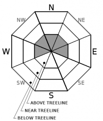
-
Likelihood ?CertainVery LikelyLikelyPossible
 Unlikely
 -
Size ?HistoricVery LargeLargeSmall

Shallow wind slabs may exist above treeline on W-NW-N-NE-E aspects. Natural and human triggered wind slab avalanches are unlikely. Any wind slab that could be triggered would be small. Watch for isolated areas of drifted snow 9,000ft and higher in steep, unsupported and extreme terrain.
Forecast Discussion
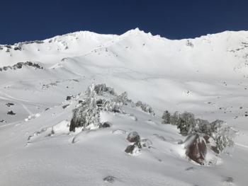
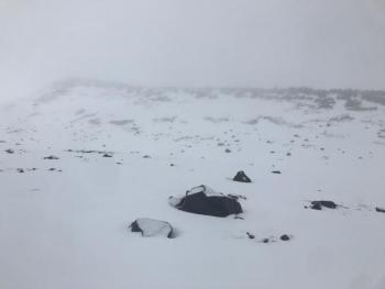
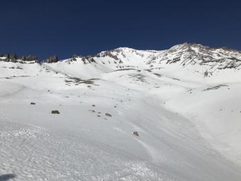
Expect sunshine and clear skies today and a return to unstable weather for the upcoming week. The recent storm plastered alpine terrain on Mount Shasta with wet snow and rime ice. Rain took a toll on our shallow snowpack below treeline. The snow at higher elevations has bonded well to the old snow surface. Today, generally safe avalanche conditions exist in the backcountry. Continue to watch for shallow wind slabs in leeward, high elevation terrain on Mount Shasta. Falling rime ice will be a significant hazard today. Be especially careful below the Trinity Chutes and Redbanks in Avalanche Gulch, and underneath rock formations in the Old Ski Bowl.
Recent Observations
Yesterday, skies cleared for the first time since our recent storm ended. No avalanches or major signs of instability were observed in the Old Ski Bowl or in Avalanche Gulch. Constant rime ice fall was observed on steep alpine slopes below rock bands. The height of new snow was variable. Areas 7,500ft and below received mostly rain and we lost a noticeable amount of snow cover below treeline. From 8,000ft to 10,000ft, a range of 5-25cm of new snow was observed. Rain on snow likely occurred as high as 11,000ft at times during the recent storm. Snow surfaces were very supportable and uniform above treeline. Wind transport of snow was visible on ridgelines above 10,000ft. Evidence of wind slab formation was difficult to find. Isolated and shallow drifts of snow were observed in leeward terrain features between 9,000-12,000ft on Mount Shasta. The skiing and riding above treeline was fast, smooth and fun.
Weather and Current Conditions
Weather Summary
A lingering ridge of high pressure will bring dry and clear weather today. Highs will be in the low 40’s, and 15-25mph southwest winds are expected above treeline. A wet and stormy week is ahead of us. A front will move through northern California tonight bringing a slight chance of rain and snow with freezing levels near 5,000ft. Heavy precipitation will begin tomorrow, and our area looks to receive over 1 inch of water by Tuesday night. Freezing levels should range between 6,000-7,000ft on Monday and Tuesday. 2-4 inches of wet snow is forecast for tomorrow near and below treeline. Colder temperatures may allow for significantly more snow above treeline with the most accumulation expected tomorrow night.
-------------------------
THIS SEASON PRECIPITATION for MT SHASTA CITY: Since October 1st (the wet season), we have received 7.19 inches of water, normal is 16.62 inches, putting us at 43% of normal. For the month of January and 2018, we have received 1.36 inches of water, normal is 1.41 inches, which is 96% of normal. Mt Shasta finished off 2017 with 44.82 inches of water; normal observed value is 43.21, which is 103% of normal.
Always check the weather before you attempt to climb Mount Shasta. Further, monitor the weather as you climb. Becoming caught on the mountain in any type of weather can compromise life and limb. Be prepared.
24 Hour Weather Station Data @ 4:00 AM
| Weather Station | Temp (°F) | Wind (mi/hr) | Snow (in) | Comments | ||||||||
|---|---|---|---|---|---|---|---|---|---|---|---|---|
| Cur | Min | Max | Avg | Avg | Max Gust | Dir | Depth | New | Water Equivalent | Settlement | ||
| Mt. Shasta City (3540 ft) | 26 | 26 | 48 | 35 | 2 | N | ||||||
| Sand Flat (6750 ft) | 25 | 25 | 33 | 30 | 11 | 0 | 0 | 0 | ||||
| Ski Bowl (7600 ft) | 31 | 25 | 32 | 28 | 19 | 0 | 0 | 0 | ||||
| Gray Butte (8000 ft) | 33 | 25 | 34 | 28 | 5 | 12 | W | |||||
| Castle Lake (5870 ft) | 31 | 30 | 36 | 32 | 0 | 0 | 0 | |||||
| Mount Eddy (6509 ft) | 32 | 26 | 32 | 29 | 2 | 5 | WSW | 7 | 0 | 0 | ||
| Ash Creek Bowl (7250 ft) | station down | |||||||||||
| Ash Creek Ridge (7895 ft) | station down |
Two Day Mountain Weather Forecast
Produced in partnership with the Medford NWS
| For 7000 ft to 9000 ft | |||
|---|---|---|---|
|
Sunday (4 a.m. to 10 p.m.) |
Sunday Night (10 p.m. to 4 a.m.) |
Monday (4 a.m. to 10 p.m.) |
|
| Weather | Mostly sunny | 30% chance of snow after 10pm. Mostly cloudy. | Snow and breezy. Chance of precipitation 100% |
| Temperature (°F) | 42 | 31 | 39 |
| Wind (mi/hr) | South 5-10 mph | South/Southeast 15-20 mph | South/Southeast 20-25 mph |
| Precipitation SWE / Snowfall (in) | / 0 | / <1 | / 1-2 |
| For 9000 ft to 11000 ft | |||
| Sunday | Sunday Night | Monday | |
| Weather | Mostly sunny and windy. | A 30% chance of snow after 10pm. Mostly cloudy and windy. | Snow and windy. Chance of precipitation 100%. |
| Temperature (°F) | 35 | 26 | 27 |
| Wind (mi/hr) | Southwest 25-35 mph, gusting 45 mph | South/Southwest 0 | South 35-45 mph, gusting 60 mph |
| Precipitation SWE / Snowfall (in) | / 0 | / 1 | / 3-7 |

