

You are here
Avalanche Advisory for 2018-02-10 05:49
- EXPIRED ON February 11, 2018 @ 5:49 amPublished on February 10, 2018 @ 5:49 am
- Issued by Nick Meyers - Shasta-Trinity National Forest
Bottom Line
Avalanche danger is LOW. Avalanches are unlikely and NORMAL CAUTION is advised. Shallow snowpack hazards exist. Beware of falling rime ice above 9500 ft.


Avalanche Problem 1: Normal Caution
-
Character ?

-
Aspect/Elevation ?
-
Likelihood ?CertainVery LikelyLikelyPossible
 Unlikely
 -
Size ?HistoricVery LargeLargeSmall

NORMAL CAUTION means:
- Watch for isolated slabs.
- Ski and ride one at a time in avalanche terrain.
- Don't regroup in run out zones.
- Basic avalanche rescue skills are essential in avalanche terrain.
Isolated slabs are related to wind and terrain. Look for places where small areas of drifting have occurred and firm layers of surface snow overlie softer layers. This will occur on the lee side of ridges, in terrain depressions, on convex terrain features, and in the lee of isolated bands of trees
Forecast Discussion
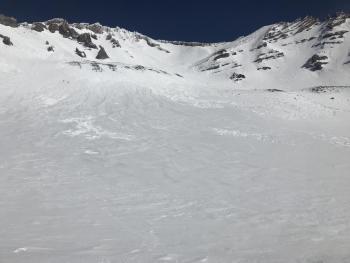
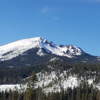
The clear, sunny weather may lure a few climbers onto the mountain. Remember, it is still winter. A winter climb of Mount Shasta significantly ups the ante. The weather and avalanche danger can change quickly. Firm, hard snow may not soften in the afternoon making descending the mountain tedious and more dangerous. A slip and fall could be fatal. Winds can howl, wind chill can be well into the negatives (deg F) and the days are still relatively short. Plan ahead and prepare properly. Know your own and your group limits. Falling rime ice and rockfall is a concern above 9500 ft. Firm, glazed snow surfaces exist. Wear a helmet and bring an ice axe, crampons, and the knowledge to use them if traveling on steep terrain.
Recent Observations
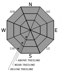
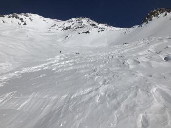
A wide array of snow surfaces exist: rough, wind eroded features; smooth, glazed and icy snow; softer melt-freeze surfaces and various sastrugi formations. Enjoyable, soft (with good timing) melt-freeze corn snow can be found in select swaths of terrain above treeline on E-SE-S and some SW facing slopes. Falling rime ice is still a concern as many rocks still have chunks of rime stuck to them. For 10 days now, we have not observed any significant signs of instability and/or avalanche(s).
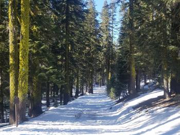
Upper Sand Flat cross-country ski trails are still usable.
All other areas within the forecast area, aside from Mount Shasta itself, are not in play due to lack of snow. Below treeline, snow is melting fast and shallow snowpack hazards are an increasing concern.
Weather and Current Conditions
Weather Summary
High pressure will continue to produce mostly clear skies, dry conditions, and near normal temperatures through tonight. A wave of weather will drop south through the region on Sunday, pushing precipitation and much cooler air. Overall, this system is not expected to bring significant rainfall.
Windy conditions on the mountain this morning should diminish throughout the day.
24 Hour Weather Station Data @ 3:00 AM
| Weather Station | Temp (°F) | Wind (mi/hr) | Snow (in) | Comments | ||||||||
|---|---|---|---|---|---|---|---|---|---|---|---|---|
| Cur | Min | Max | Avg | Avg | Max Gust | Dir | Depth | New | Water Equivalent | Settlement | ||
| Mt. Shasta City (3540 ft) | 35 | 34 | 68 | 48.5 | 4 | N | ||||||
| Sand Flat (6750 ft) | 34 | 34 | 48 | 41 | 19 | 0 | 0 | 0 | ||||
| Ski Bowl (7600 ft) | 42 | 35 | 49.5 | 42.5 | 39 | 0 | 0 | |||||
| Gray Butte (8000 ft) | 34.5 | 30.5 | 46.5 | 40 | 14 | 43 | NNW | |||||
| Castle Lake (5870 ft) | 31.5 | 31.5 | 52 | 42 | 8 | 0 | 0 | |||||
| Mount Eddy (6509 ft) | 29 | 29 | 46 | 39.5 | 3 | 17 | SSE | 19.5 | 0 | 0 | ||
| Ash Creek Bowl (7250 ft) | 0 | 0 | 0 | 0 | 0 | 0 | station down | |||||
| Ash Creek Ridge (7895 ft) | 0 | 0 | 0 | 0 | 0 | 0 | station down |
Two Day Mountain Weather Forecast
Produced in partnership with the Medford NWS
| For 7000 ft to 9000 ft | |||
|---|---|---|---|
|
Saturday (4 a.m. to 10 p.m.) |
Saturday Night (10 p.m. to 4 a.m.) |
Sunday (4 a.m. to 10 p.m.) |
|
| Weather | Sunny | Mostly clear | Partly cloudy in the morning, then mostly cloudy in the afternoon |
| Temperature (°F) | 38 | 23 | 40 |
| Wind (mi/hr) | N 10-15 mi/hr | NE 5-10 mi/hr | W 5-10 mi/hr |
| Precipitation SWE / Snowfall (in) | / 0 | / 0 | / 0 |
| For 9000 ft to 11000 ft | |||
| Saturday | Saturday Night | Sunday | |
| Weather | Sunny and windy | Clear and blustery | Partly cloudy in the morning, slight chance of snow showers in the late afternoon. Freezing levels near 3,400 feet. |
| Temperature (°F) | 28 | 26 | 26 |
| Wind (mi/hr) | N 30-40 mi/hr | NE 0 | W 20-30 mi/hr |
| Precipitation SWE / Snowfall (in) | / 0 | / 0 | / 0 |
Season Precipitation for Mount Shasta City
| Period | Measured (in) | Normal (in) | Percent of Normal (%) |
|---|---|---|---|
| From Oct 1, 2025 (the wet season) | 10.11 | 24.46 | 41 |
| Month to Date (since Jun 1, 2026) | 0.00 | 2.19 | 0 |
| Year to Date (since Jan 1, 2026) | 4.28 | 9.25 | 46 |

