

You are here
Avalanche Advisory for 2018-02-14 05:08
- EXPIRED ON February 15, 2018 @ 5:08 amPublished on February 14, 2018 @ 5:08 am
- Issued by Aaron Beverly - Mount Shasta Avalanche Center
Bottom Line
Avalanche danger is LOW. NORMAL CAUTION is advised. Firm and icy snow surfaces are widespread and shallow snowpack hazards exist. Icefall is a concern above 10,000 ft on Mount Shasta.


Avalanche Problem 1: Normal Caution
-
Character ?

-
Aspect/Elevation ?
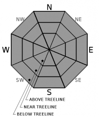
-
Likelihood ?CertainVery LikelyLikelyPossible
 Unlikely
 -
Size ?HistoricVery LargeLargeSmall

NORMAL CAUTION means:
- Watch for isolated slabs.
- Ski and ride one at a time in avalanche terrain.
- Don't regroup in run out zones.
- Basic avalanche rescue skills are essential in avalanche terrain.
Isolated slabs are related to wind and terrain. Look for places where small areas of drifting have occurred and firm layers of surface snow overlie softer layers. This will occur on the lee side of ridges, in terrain depressions, on convex terrain features, and in the lee of isolated bands of trees.
Forecast Discussion
Yesterday's cool temperatures and moderate winds will have left the snowpack on Mount Shasta unchanged. Expect wind eroded and smooth icy snow surfaces. Wear a helmet and bring an ice axe, crampons, and the knowledge to use them if traveling on steep terrain.
Although temperatures will be cold today and tomorrow, strong winds can dislodge rime ice caked to Red Banks and the Trinity Chutes. Beware of this hazard above 10,000 ft.
LOW avalanche danger and normal caution will continue at all elevations until a significant weather event occurs.
Recent Observations
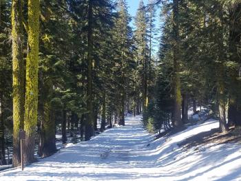
Clear skies and moderate easterly winds prevailed yesterday on Mount Shasta with highs reaching 39 degrees at 7600 ft. The snowpack is 1-4 ft deep above 7,000 ft. It is a consolidated mass comprised mostly of melt-freeze crusts and ice layers.
The Castle Lake and Mount Edddy backcountry has 8 to 12 inches of snow but coverage is inconsistent and sparse. Winter recreation is limited. Parks Creek Pass received 2 inches of new snow from Sunday's storm and has the best coverage. See the most recent observation for details.
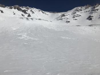
No avalanches or evidence of unstable snow have been observed so far this month.
Weather and Current Conditions
Weather Summary
A cold front moves in today bringing snow levels down to 3000 ft and less than inch of snow. Thursday through Saturday will bring clear dry weather followed by a weak system on Sunday that could produce an inch of snow. Models show more precipitation possible towards the end of next week.
24 Hour Weather Station Data @ 6:00 AM
| Weather Station | Temp (°F) | Wind (mi/hr) | Snow (in) | Comments | ||||||||
|---|---|---|---|---|---|---|---|---|---|---|---|---|
| Cur | Min | Max | Avg | Avg | Max Gust | Dir | Depth | New | Water Equivalent | Settlement | ||
| Mt. Shasta City (3540 ft) | 38 | 18 | 53 | 35 | 1 | N | ||||||
| Sand Flat (6750 ft) | 27 | 26 | 41 | 32 | 19 | 0 | 0 | 0 | ||||
| Ski Bowl (7600 ft) | 25.5 | 23 | 38.5 | 30 | 39.5 | 0 | 0 | 0 | ||||
| Gray Butte (8000 ft) | 22.5 | 22 | 35.5 | 28.5 | 14 | 31 | WNW | |||||
| Castle Lake (5870 ft) | 30 | 22.5 | 42.5 | 32 | 8 | 0 | 0 | |||||
| Mount Eddy (6509 ft) | 27 | 21.5 | 38.5 | 30.5 | 2 | 8 | WSW | 21 | 0 | 0 | ||
| Ash Creek Bowl (7250 ft) | Station down | |||||||||||
| Ash Creek Ridge (7895 ft) | Station down |
Two Day Mountain Weather Forecast
Produced in partnership with the Medford NWS
| For 7000 ft to 9000 ft | |||
|---|---|---|---|
|
Wednesday (4 a.m. to 10 p.m.) |
Wednesday Night (10 p.m. to 4 a.m.) |
Thursday (4 a.m. to 10 p.m.) |
|
| Weather | Mostly cloudy. A 60% chance of snow showers. | A 60% chance of snow before 10 p.m. | Sunny. |
| Temperature (°F) | 31 | 20 | 35 |
| Wind (mi/hr) | SW 10-15 mi/hr | NW 5-10 mi/hr | N 10-15 mi/hr |
| Precipitation SWE / Snowfall (in) | / < .5 | / < .5 | / 0 |
| For 9000 ft to 11000 ft | |||
| Wednesday | Wednesday Night | Thursday | |
| Weather | A 80% chance of snow. Windy. Wind chills as low as -1 deg F. | A 80% chance of snow before 10 p.m. Windy. Wind chills as low as -12 deg F. | Sunny. Windy. Wind chills as low as 5 deg F. |
| Temperature (°F) | 19 | 10 | 23 |
| Wind (mi/hr) | W 30-35 mi/hr | NW < .5 | N 25-30 mi/hr |
| Precipitation SWE / Snowfall (in) | / < .5 | / < .5 | / 0 |
Season Precipitation for Mount Shasta City
| Period | Measured (in) | Normal (in) | Percent of Normal (%) |
|---|---|---|---|
| From Oct 1, 2025 (the wet season) | 10.15 | 25.41 | 40 |
| Month to Date (since Jun 1, 2026) | 0.04 | 3.14 | 1 |
| Year to Date (since Jan 1, 2026) | 4.32 | 10.20 | 42 |

