

You are here
Avalanche Advisory for 2018-03-01 06:28
- EXPIRED ON March 2, 2018 @ 6:28 amPublished on March 1, 2018 @ 6:28 am
- Issued by Nick Meyers - Shasta-Trinity National Forest
Bottom Line
A WINTER STORM WARNING is in effect until 7 AM PST Saturday.
Over the next 48 hours, feet of new snow and high winds will create new wind slab, storm slab and cornice fall avalanche problems. Travel in avalanche terrain is not recommended. Natural avalanches are possible and human triggered avalanches are likely.


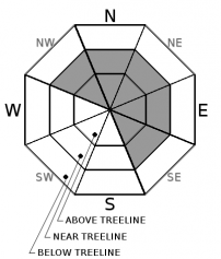
Avalanche Problem 1: Wind Slab
-
Character ?

-
Aspect/Elevation ?
-
Likelihood ?CertainVery LikelyLikelyPossible
 Unlikely
 -
Size ?HistoricVery LargeLargeSmall

Wind Slabs are most reactive during a wind/storm event and the first day or two after it has ended. Wind Slabs will form in specific areas depending on the wind speed and direction. They form on the lee aspects of ridgelines, cross-loaded gullies, or other terrain features. Areas around cliff bands and the lee side of krumholtz groves can also develop Wind Slabs. At stronger wind speeds, unusual loading/deposition patterns may occur. As wind speeds increase, the Wind Slabs may form further down slope than normally suspected, and may be found in small pockets in steep gullies or even down in the trees. Look for convex pillows of wind-drifted snow on the lee side of ridges and other terrain features. The Wind Slab may have a chalky look and feel. Wind Slabs can be very hard, and may present a hollow drum like sound as you traverse across slope. Avoid by sticking to sheltered or wind-scoured areas.
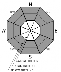
Avalanche Problem 2: Storm Slab
-
Character ?

-
Aspect/Elevation ?
-
Likelihood ?CertainVery LikelyLikelyPossible
Unlikely
-
Size ?HistoricVery LargeLargeSmall
Storm Slabs tend to form in sheltered areas where new snow falls with light winds. They can occur on any steep open slope, and are often found on several aspects at the same time. They are easiest to trigger during periods of heavy snow and typically stabilize within a day or two after the storm cycle has ended. Natural activity on indicator slopes are often the best clues that a Storm Slab problem exists. You can reduce your risk from Storm Slabs by waiting a day or two after a storm before venturing into steep avalanche terrain.
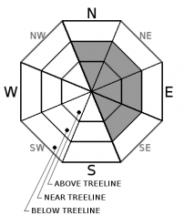
Avalanche Problem 3: Cornice
-
Character ?

-
Aspect/Elevation ?
-
Likelihood ?CertainVery LikelyLikelyPossible
Unlikely
-
Size ?HistoricVery LargeLargeSmall
Cornices develop whenever snow is available for transport and the wind is sufficiently strong to move the snow. Cornices can form quickly with favorable wind speeds and abundant available snow, typically following a recent storm. Cornices form on the downwind (leeward) side of sharp terrain features. Ridges above treeline are the most common locations. Cornices also form downwind of vertical ridge lines and tops of couloirs, in a process referred to as cross-loading. Fortunately, Cornices are easy to see. Weather and terrain awareness are the best tools for recognizing potential cornice problems. Cornices can never be trusted; and hence, avoiding them is necessary for safe backcountry travel. While moving along ridge lines stay well back from areas with cornice formation.
Forecast Discussion
No nerdy snow science to talk about today. Mount Shasta is on the brink of a strong winter storm that will impact the area over the next couple days. Already, we've recorded up to a foot of fresh snow overnight with high winds on the mountain. This story will continue over the next 48 hours. Remembering the 5 red flags for avalanche danger can keep you out of trouble most of the time.
- Recent avalanche activity
- Shooting cracks or whoomphing
- Significant snowfall in 24 hours
- Strong winds
- Temperature rise
Prior to this storm, Castle Lake and the Eddy Mountains have been out of play due to a shallow snowpack. It has been the same for the Pilgrim Creek snowmobile park, though this storm may change things. Logging operations have been in full swing along the 19 road near the snopark. It's uncertain if they'll plow or not.
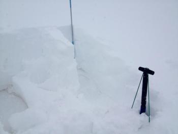
Recent Observations
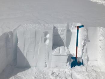
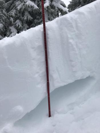
- Avalanche start zones are scoured to icy surfaces or rock, as are the tops of moraines and ridges.
- Dry, low density snow near and above treeline has been stripped away by former N/NW winds and deposited on S/SE aspects in gullies and terrain depressions between 7500 and 10,000 ft.
- Wind slabs in leeward areas with a mix of new and recent windloading have been stubborn to trigger. New slabs atop the old icy snow surface were easy to trigger with hand tests, but areas where this configuration was found were small and few.
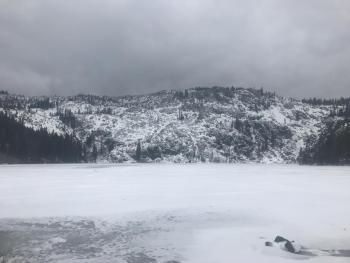
- Castle Lake is frozen. A skiff of existing snow blanketed the landscape. At 1300 hours yesterday, winds were howling out of the S/SW, evidence of the incoming storm. Precipitation began to fall at 1500 hours.
Weather and Current Conditions
Weather Summary
The National Weather Service has issued a WINTER STORM WARNING, in effect until 7 AM PST Saturday. We are in the midst of the most significant winter storm of the season for Mount Shasta. Snow measured in feet and hurricane force winds are expected on the mountain. You will encounter heavy snow, poor visibility, nuking southwesterly wind and extreme wind chill on the mountain today. This morning, .66 inches of water has been recorded at the Old Ski Bowl weather station, which has translated into 11 inches of new snow overnight. An additional .77 inches of water is expected through midnight tonight and .86 inches of water for Friday. This could mean several more feet of snow by Saturday morning. Snow levels will be near town or lower. Winds will not abate for the near future.
24 Hour Weather Station Data @ 4:00 AM
| Weather Station | Temp (°F) | Wind (mi/hr) | Snow (in) | Comments | ||||||||
|---|---|---|---|---|---|---|---|---|---|---|---|---|
| Cur | Min | Max | Avg | Avg | Max Gust | Dir | Depth | New | Water Equivalent | Settlement | ||
| Mt. Shasta City (3540 ft) | 32 | 28 | 36 | 31.5 | 4 | ESE | ||||||
| Sand Flat (6750 ft) | station down | |||||||||||
| Ski Bowl (7600 ft) | 19.5 | 16 | 21.5 | 19 | 54 | 11 | 0.66 | 0 | ||||
| Gray Butte (8000 ft) | 18.5 | 14 | 21 | 17.5 | 15 | 37 | WNW | |||||
| Castle Lake (5870 ft) | 24.5 | 20.5 | 29.5 | 24 | 20 | 9 | 0 | |||||
| Mount Eddy (6509 ft) | 24 | 11.5 | 27.5 | 22.5 | 2 | 13 | WSW | 39 | 9 | 0 | ||
| Ash Creek Bowl (7250 ft) | station down | |||||||||||
| Ash Creek Ridge (7895 ft) | station down |
Two Day Mountain Weather Forecast
Produced in partnership with the Medford NWS
| For 7000 ft to 9000 ft | |||
|---|---|---|---|
|
Thursday (4 a.m. to 10 p.m.) |
Thursday Night (10 p.m. to 4 a.m.) |
Friday (4 a.m. to 10 p.m.) |
|
| Weather | Snow showers. Windy. Chance of snow 100%. | Snow showers. Breezy. Chance of snow 100%. | Snow showers. Windy. Chance of snow 80%. |
| Temperature (°F) | 22 | 12 | 17 |
| Wind (mi/hr) | S 15-20 mi/hr | SW 10-15 mi/hr | S 15-20 mi/hr |
| Precipitation SWE / Snowfall (in) | / 6-10 | / 6-10 | / 8-12 |
| For 9000 ft to 11000 ft | |||
| Thursday | Thursday Night | Friday | |
| Weather | Snow showers. Windy. Snow heavy at times. Chance of snow 100%. | Snow showers. Windy. Snow heavy at times. Chance of snow 100% | Snow showers. Windy. Snow heavy at times. Chance of snow 80%. |
| Temperature (°F) | 15 | 2 | 6 |
| Wind (mi/hr) | SW 40-50 mi/hr | SW 8-12 | SW 30-40 mi/hr |
| Precipitation SWE / Snowfall (in) | / 8-12 | / 8-12 | / 10-14 |
Season Precipitation for Mount Shasta City
| Period | Measured (in) | Normal (in) | Percent of Normal (%) |
|---|---|---|---|
| From Oct 1, 2025 (the wet season) | 10.89 | 29.50 | 37 |
| Month to Date (since Jun 1, 2026) | 0.78 | 7.23 | 11 |
| Year to Date (since Jan 1, 2026) | 5.06 | 14.29 | 35 |

