

You are here
Avalanche Advisory for 2018-03-03 06:02
- EXPIRED ON March 4, 2018 @ 6:02 amPublished on March 3, 2018 @ 6:02 am
- Issued by Nick Meyers - Shasta-Trinity National Forest
Bottom Line
A WINTER WEATHER ADVISORY is in effect from 4 AM until 10 PM PST this evening for Mount Shasta. CONSIDERABLE avalanche danger exists near and above treeline today due to touchy wind slab and/or cornice fall avalanche problems. An additional round of snowfall will continue to impact mountinous terrain. Avoid slopes steeper than 30 degrees without exposure to steeper terrain above.


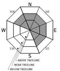
Avalanche Problem 1: Wind Slab
-
Character ?

-
Aspect/Elevation ?
-
Likelihood ?CertainVery LikelyLikelyPossible
 Unlikely
 -
Size ?HistoricVery LargeLargeSmall

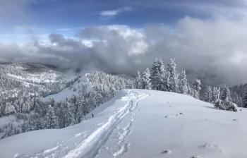
Wind slabs, primarily above treeline, remain our greatest concern today. Evidence of previous wind loading was observed yesterday and drifts were observed 3-5 feet deep. A ton of snow remains available for new wind transport and existing wind loaded areas are abundant. Triggering a wind slab could produce a large avalanche. Wind Slabs are most reactive during a wind/storm event and the first day or two after it has ended. Look for convex pillows of wind-drifted snow on the NW-N-NE-E-SE aspects of ridges and other terrain features, near and above treeline. The wind slab may have a chalky look and feel. Wind slabs can be very hard, and may present a hollow drum like sound as you traverse across slope. Avoid by sticking to sheltered or wind-scoured areas.
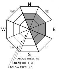
Avalanche Problem 2: Cornice
-
Character ?

-
Aspect/Elevation ?
-
Likelihood ?CertainVery LikelyLikelyPossible
Unlikely
-
Size ?HistoricVery LargeLargeSmall
Cornices develop whenever snow is available for transport and the wind is sufficiently strong to move the snow. Cornices form on the downwind (leeward) side of sharp terrain features. Ridges above treeline are the most common locations. Weather and terrain awareness are the best tools for recognizing potential cornice problems. Fresh cornices can never be trusted; avoiding them is necessary for safe backcountry travel. While moving along ridge lines, stay well back from areas with cornice formation.
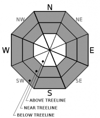
Avalanche Problem 3: Storm Slab
-
Character ?

-
Aspect/Elevation ?
-
Likelihood ?CertainVery LikelyLikelyPossible
Unlikely
-
Size ?HistoricVery LargeLargeSmall
Evidence of the storm slab avalanche problem has been hard to come by. However, with an additional round of snowfall today, small storm slabs below and near treeline in sheltered areas are possible. Storm slabs are best managed by conservative terrain choices during and after storms until the storm snow has stabilized.
Forecast Discussion
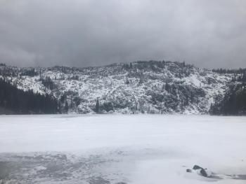
Mount Shasta has just received 2 to 3 feet of fresh snow over the past two days. Additional snowfall is expected today. While no glaring signs of instability have been observed, the simple data points to cautious route finding and decision making in the backcountry. The skiing and riding conditions are excellent, but routes should be chosen to minimize, or better yet, avoid steep terrain as an avalanche could be large. Enjoy the powder, but be careful out there.
Recent Observations
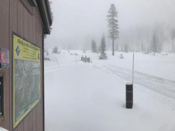
- The Everitt Memorial Highway and Castle Lake roads are OPEN, as well as the Mt Shasta Ski Park. Grooming has begun at Pilgrim Creek Snowmobile Park also.
- Several backcountry skiers observed cracking and whoomfing in numerous areas along Green Butte Ridge, near treeline yesterday.
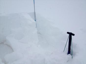
- The Mount Shasta Ski Park ski patrol was able to get easy failures within storm snow layers, 20 inches down from surface, backside of Coyote Butte.
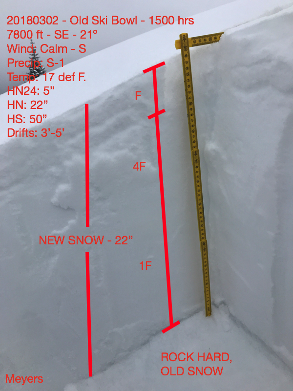
- Last wave of snow deposited 5-10 inches of dry, low density snow on top of existing storm layer.
- Storm totals equal 2 to 3 feet on top of old snow surfaces. Areas below 6,500 feet, storm snow fell on mostly bare ground.
- New snow is right side up. I could not find good evidence of the storm slab problem below and near treeline.
- Evidence of previous wind loading was observed near and above treeline. Wind drifts were 3 to 5 feet deep. Copius amounts of fresh, low density snow is available for new wind transport.
- Visibility was and has been very poor above 8,000 feet. Above treeline and alpine terrain, conditions and stability is uncertain.
- No natural avalanches have been observed yet.
- Winds were eerily calm. A light wind could be felt out of the south and picked up in the late afternoon below treeline. Numerous showers brought periods of intense snowfall throughout the day.
Weather and Current Conditions
Weather Summary
A WINTER WEATHER ADVISORY is in effect from 4 AM until 10 PM PST this evening for Mount Shasta... Additional snow accumulations of 3 to 6 inches over the mountains with localized amounts of up to 9 inches are possible today. A cold upper level trough is centered along the Oregon coast and will linger today with isolated to numerous snow showers. Favorable upslope southerly flow will veer to westerly throughout the day. Showers will taper off later tonight and a few light flurries are possible Sunday, mainly over higher terrain. Dry and warmer weather develops next week. By Wednesday, a broad trough will approach from the W/SW and a shift back to wet weather is likely.
24 Hour Weather Station Data @ 3:00 AM
| Weather Station | Temp (°F) | Wind (mi/hr) | Snow (in) | Comments | ||||||||
|---|---|---|---|---|---|---|---|---|---|---|---|---|
| Cur | Min | Max | Avg | Avg | Max Gust | Dir | Depth | New | Water Equivalent | Settlement | ||
| Mt. Shasta City (3540 ft) | 32 | 28 | 36 | 31.5 | 4 | ESE | ||||||
| Sand Flat (6750 ft) | station down | |||||||||||
| Ski Bowl (7600 ft) | 8.5 | 4.5 | 33 | 14.5 | 66.5 | 8 | 0.24 | 1.5 | ||||
| Gray Butte (8000 ft) | 9.5 | 5.5 | 19 | 12 | 8 | 25 | SSE | |||||
| Castle Lake (5870 ft) | 17 | 12.5 | 22.5 | 18 | 35 | 5.5 | 1 | |||||
| Mount Eddy (6509 ft) | 10 | 10 | 19.5 | 15.5 | 1 | 12 | SW | 50 | 6.5 | 1.5 | ||
| Ash Creek Bowl (7250 ft) | station down | |||||||||||
| Ash Creek Ridge (7895 ft) | station down |
Two Day Mountain Weather Forecast
Produced in partnership with the Medford NWS
| For 7000 ft to 9000 ft | |||
|---|---|---|---|
|
Saturday (4 a.m. to 10 p.m.) |
Saturday Night (10 p.m. to 4 a.m.) |
Sunday (4 a.m. to 10 p.m.) |
|
| Weather | Widespread snow showers, chance of snow 80% | Mostly cloudy, show showers. Chance of snow 70% | Partly sunny with a 30% chance of snow showers. |
| Temperature (°F) | 25 | 16 | 27 |
| Wind (mi/hr) | S 5-10 mi/hr | S 0-5 mi/hr | S 0-5 mi/hr |
| Precipitation SWE / Snowfall (in) | / 3-6 | / 1-2 | / 0-1 |
| For 9000 ft to 11000 ft | |||
| Saturday | Saturday Night | Sunday | |
| Weather | Widespread snow showers. Breezy. Chance of precipitation is 80%. | Snow showers. Chance of precipitation is 90%. | Partly sunny and cold. Chance of precipitation is 30%. |
| Temperature (°F) | 7 | 5 | 11 |
| Wind (mi/hr) | SW 10-20 mi/hr | W 4-8 | W 5-10 mi/hr |
| Precipitation SWE / Snowfall (in) | / 4-8 | / 1-3 | / 0-.5 |
Season Precipitation for Mount Shasta City
| Period | Measured (in) | Normal (in) | Percent of Normal (%) |
|---|---|---|---|
| From Oct 1, 2025 (the wet season) | 12.20 | 30.03 | 41 |
| Month to Date (since Jun 1, 2026) | 1.31 | 0.53 | 247 |
| Year to Date (since Jan 1, 2026) | 6.37 | 14.82 | 43 |

