

You are here
Avalanche Advisory for 2018-03-07 06:39
- EXPIRED ON March 8, 2018 @ 6:39 amPublished on March 7, 2018 @ 6:39 am
- Issued by Aaron Beverly - Mount Shasta Avalanche Center
Bottom Line
The avalanche danger is LOW at all elevations. Natural and human-triggered avalanches are unlikely. A winter storm will begin to impact the area after 4 p.m. Wind slabs may start to form on NW/N/NE aspects throughout the night.


Avalanche Problem 1: Wind Slab
-
Character ?

-
Aspect/Elevation ?
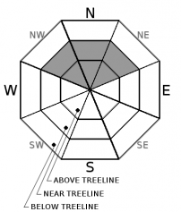
-
Likelihood ?CertainVery LikelyLikelyPossible
 Unlikely
 -
Size ?HistoricVery LargeLargeSmall

Wind slabs have not been observed over the last few days and are unlikely to be encountered today. However, north aspects retain low density snow that could be transported by strong winds. With 2-4 inches of snow predicted tonight accompanied by S winds over 40 mi/hr, wind slabs may begin to form and grow after 4 p.m. near and above treeline. Look for these on NW/N/NE aspects. Signs of wind slabs include hollow sounding snow, shooting cracks, and wind pillows. When in doubt, stick to windward sides of ridges and avoid slopes over 35 degrees.
Forecast Discussion
Conditions will remain mostly unchanged today with LOW avalanche danger expected at all elevations. Sunny and warm weather yesterday coupled with below freezing temperatures last night may have produced melt freeze crusts on southerly aspects. North aspects should continue to hold dry low density snow. Roller balls and pinwheels may continue on steep southerly slopes, but are not expected to pose a significant avalanche concern. A winter storm will begin to impact the area after 4 p.m. today. If you are spending the night on the mountain, be prepared for strong winds, low wind chills, and the development of wind slabs on NW/N/NE aspects.
Recent Observations
Temperatures over the last 24 hours have ranged from 31-45 °F. Winds have been light, averaging 8 mi/hr.
Sun exposed snow surfaces to at least 8000 ft turned moist yesterday. Roller balls were observed on S/SE steep aspects. North facing slopes retain some dry low density snow that could be transported by strong winds.
A tour to Ash Creek Butte saw a snowpack with continued settlement and increased stability. Snow from the last storm was right side up, up to 100 cm (3 ft) in depth, with F-4F-1F hardness. Column test failures were stubborn to trigger. Small cornices on north aspects could be broken with moderate ski stomping. No obvious signs of avalanches or a wind slab problem were seen. See the most recent observation for details.

Weather and Current Conditions
Weather Summary
Today expect increased cloud cover and winds as a low pressure system moves warm wet air into the area. Precipitation will begin after 4 p.m. There is some uncertainty on the timing and amount of snow in this one. Generous forecasts are predicting 2-4 inches of snow tonight and 3-4 tomorrow at mid elevations. However, total precipitable water is predicted to be .79 inches between tonight and Saturday morning. This is likely to translate into 6-12 inches of snow from mid to high elevations. The bulk of this looks to fall Thursday night and Friday morning.
Snow levels will range from 5000 to 5500 ft.
24 Hour Weather Station Data @ 6:00 AM
| Weather Station | Temp (°F) | Wind (mi/hr) | Snow (in) | Comments | ||||||||
|---|---|---|---|---|---|---|---|---|---|---|---|---|
| Cur | Min | Max | Avg | Avg | Max Gust | Dir | Depth | New | Water Equivalent | Settlement | ||
| Mt. Shasta City (3540 ft) | 35 | 23 | 59 | 41 | 1 | N | ||||||
| Sand Flat (6750 ft) | station down | |||||||||||
| Ski Bowl (7600 ft) | 35.5 | 31.5 | 45.5 | 38 | 58.1 | 0 | 0 | 3.5 | ||||
| Gray Butte (8000 ft) | 34.5 | 31.5 | 42 | 36 | 8 | 18 | ESE | |||||
| Castle Lake (5870 ft) | 35.5 | 33 | 58.5 | 42 | 27.5 | 0 | 2.5 | |||||
| Mount Eddy (6509 ft) | 36 | 27.5 | 46 | 38.5 | 2 | 9 | SW | 43.5 | 0 | 2 | ||
| Ash Creek Bowl (7250 ft) | station down | |||||||||||
| Ash Creek Ridge (7895 ft) | station down |
Two Day Mountain Weather Forecast
Produced in partnership with the Medford NWS
| For 7000 ft to 9000 ft | |||
|---|---|---|---|
|
Wednesday (4 a.m. to 10 p.m.) |
Wednesday Night (10 p.m. to 4 a.m.) |
Thursday (4 a.m. to 10 p.m.) |
|
| Weather | Snow likely after 4 p.m. Mostly cloudy. Breezy. Chance of precipitation is 60%. | Snow. Low around 31. Windy. Chance of precipitation is 80%. | Snow then snow showers. Breezy. Chance of precipitation is 90%. |
| Temperature (°F) | 44 | 33 | 36 |
| Wind (mi/hr) | S 5-10 mi/hr | S 15-20 mi/hr | S 15-20 mi/hr |
| Precipitation SWE / Snowfall (in) | / 0 | / 2-4 | / 3-4 |
| For 9000 ft to 11000 ft | |||
| Wednesday | Wednesday Night | Thursday | |
| Weather | Snow likely after 4 p.m. Partly sunny. Wind chill values as low as 13. Windy. Chance of precipitation is 60%. | Snow. Wind chill values as low as -4. Windy. Chance of precipitation is 80%. | Snow then snow showers. Wind chill values as low as 0. Windy. Chance of precipitation is 90%. |
| Temperature (°F) | 29 | 19 | 22 |
| Wind (mi/hr) | S 25-30 mi/hr | S 0 | SW 40-50 mi/hr |
| Precipitation SWE / Snowfall (in) | / 0 | / 3-5 | / 4-6 |
Season Precipitation for Mount Shasta City
| Period | Measured (in) | Normal (in) | Percent of Normal (%) |
|---|---|---|---|
| From Oct 1, 2025 (the wet season) | 12.20 | 31.00 | 39 |
| Month to Date (since Jun 1, 2026) | 1.31 | 1.50 | 87 |
| Year to Date (since Jan 1, 2026) | 6.37 | 15.79 | 40 |

