

You are here
Avalanche Advisory for 2018-03-17 06:17
- EXPIRED ON March 18, 2018 @ 6:17 amPublished on March 17, 2018 @ 6:17 am
- Issued by Nick Meyers - Shasta-Trinity National Forest
Bottom Line
LOW danger and normal caution is advised for today. If and when we see wind speeds increase on Mount Shasta, fresh snow remains available for wind transport. Leeward slopes above treeline could see active wind loading and the avalanche danger will rise on those slopes. Triggering a wind slab is unlikely at the moment, but pay attention for changing conditions should winds pick up over the next couple days.


Avalanche Problem 1: Wind Slab
-
Character ?

-
Aspect/Elevation ?
-
Likelihood ?CertainVery LikelyLikelyPossible
 Unlikely
 -
Size ?HistoricVery LargeLargeSmall

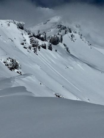
Finding and triggering any existing wind slab above treeline is going to be difficult today. The only real concern lies for any new, active wind loading of the fresh, low density storm snow. The wind forecast is not notable, but pay attention to any localized winds in alpine terrain that may transport snow onto leeward slopes. If you see active wind loading, pay attention to where it's headed and use caution on those slopes. Leeward slopes steeper than 35 degrees should warrant the most cautious decision making where active wind loading is present.
Wind slabs can be recognized by the appearance of the snow surface, changes in surface snow hardness, hollow, drum-like sounds and/or shooting cracks. Winds that vary in strength and direction can produce complex and unexpected wind slab patterns. Use normal caution.
Forecast Discussion
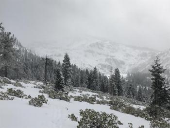
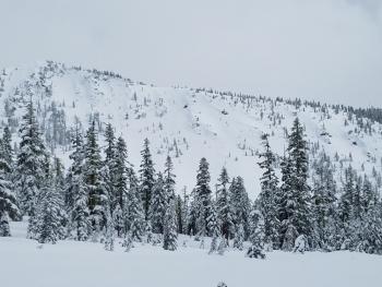
Sliders and riders have been using sick days and enjoying the low density, right side up March storm...evidence gathered from the wide grins and un-familiar weekday faces observed at Bunny Flat. Our below normal snowpack continues to grow, however obstacles still lurk below the snow surface, so continue to be careful. Castle Lake area does not have a usable snowpack currently, the lake is frozen with soft edges. The Eddy Mountains have a barely usable snowpack. The Sand Flat winter xc-ski trails are in great shape. Pilgrim Creek snowpark is open and trails are being actively groomed.
Recent Observations
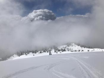
A donut hole sky provided decent visibility with shots of blue overhead for the first time in a couple days yesterday. Various methods of winter recreation layed fresh tracks upon alpine terrain of Mt Shasta. Waves of light to moderate intensity snowfall passed through at times and added an additional, low density frosting (1-2 inches) of snow to our already soft snowpack. Storm total since 3/13 is 25 inches. Snowfall total for the season is 161 inches with 76 inches on the ground currently at treeline on the mountain. Temperatures have remained cool and the effects of our higher-in-the-sky sun have not made for any breakable crust, yet. You could of had a candle-light ceremony yesterday...winds have been absent during the recent storm period and evidence of active wind-loading has been hard to come by. No recent avalanches, nor signs of instability have been observed or reported.
Weather and Current Conditions
Weather Summary
The focus now becomes on next weeks forecast, Wednesday into Friday, with this period of wet and windy weather looking increasingly likely. More on that later. For today, a chance remains for light showers, however the trend is for precipitation to diminish. Expect partly to mostly sunny skies this weekend and a warming trend for high temperatures that will still be typically a few degrees below normal.
24 Hour Weather Station Data @ 5:00 AM
| Weather Station | Temp (°F) | Wind (mi/hr) | Snow (in) | Comments | ||||||||
|---|---|---|---|---|---|---|---|---|---|---|---|---|
| Cur | Min | Max | Avg | Avg | Max Gust | Dir | Depth | New | Water Equivalent | Settlement | ||
| Mt. Shasta City (3540 ft) | 31 | 29 | 35 | 31.5 | 2 | N | ||||||
| Sand Flat (6750 ft) | station down | |||||||||||
| Ski Bowl (7600 ft) | 9 | 9 | 27.5 | 16.5 | 76.8 | 1.4 | 0.14 | 2 | ||||
| Gray Butte (8000 ft) | 12 | 11.5 | 26 | 16.5 | 5 | 18 | W | |||||
| Castle Lake (5870 ft) | 0 | 0 | 0 | 0 | 0 | 0 | 0 | station down | ||||
| Mount Eddy (6509 ft) | 11.5 | 11.5 | 26 | 20 | 1 | 7 | 50.6 | 3.9 | 3 | |||
| Ash Creek Bowl (7250 ft) | station down | |||||||||||
| Ash Creek Ridge (7895 ft) | station down |
Two Day Mountain Weather Forecast
Produced in partnership with the Medford NWS
| For 7000 ft to 9000 ft | |||
|---|---|---|---|
|
Saturday (4 a.m. to 10 p.m.) |
Saturday Night (10 p.m. to 4 a.m.) |
Sunday (4 a.m. to 10 p.m.) |
|
| Weather | Partly to mostly cloudy, 50% chance of snow showers. | Partly to mostly cloudy, 30% chance of snow showers. | Partly to mostly cloudy. |
| Temperature (°F) | 30 | 19 | 33 |
| Wind (mi/hr) | W 0-5 mi/hr | NW 0-5 mi/hr | S 0-5 mi/hr |
| Precipitation SWE / Snowfall (in) | / 0-1 | / 0-.5 | / 0 |
| For 9000 ft to 11000 ft | |||
| Saturday | Saturday Night | Sunday | |
| Weather | Mostly cloudy, cold and blustery. Chance of snow 50%. | Mostly cloudy, cold and blustery. Chance of snow 30%. | Partly sunny and cold, windy. Wind chill values as low as -17 F. |
| Temperature (°F) | 11 | 11 | 14 |
| Wind (mi/hr) | NW 5-10 mi/hr | NW 0-1 | W 10-15 mi/hr |
| Precipitation SWE / Snowfall (in) | / 0-1 | / 0-.5 | / 0 |
Season Precipitation for Mount Shasta City
| Period | Measured (in) | Normal (in) | Percent of Normal (%) |
|---|---|---|---|
| From Oct 1, 2025 (the wet season) | 14.33 | 33.20 | 43 |
| Month to Date (since Jun 1, 2026) | 3.44 | 3.70 | 93 |
| Year to Date (since Jan 1, 2026) | 8.50 | 17.99 | 47 |

