

You are here
Avalanche Advisory for 2018-03-19 06:22
- EXPIRED ON March 20, 2018 @ 6:22 amPublished on March 19, 2018 @ 6:22 am
- Issued by Andrew Kiefer - Mt Shasta Avalanche Center
Bottom Line
LOW danger exists at all elevations and NORMAL CAUTION is advised. Snow surfaces will experience intense solar radiation today, and minor wet loose avalanche activity is expected to continue. Icefall is a concern in upper elevation terrain on Mount Shasta.


Avalanche Problem 1: Normal Caution
-
Character ?

-
Aspect/Elevation ?
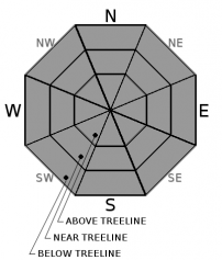
-
Likelihood ?CertainVery LikelyLikelyPossible
 Unlikely
 -
Size ?HistoricVery LargeLargeSmall

Continue to watch for isolated wind slabs above treeline. Look for places where small areas of drifting have occurred and firm layers of surface snow overlie softer layers. Often this will occur on the lee side of ridges, in terrain depressions, on convex terrain features and in the lee of isolated bands of trees.
Forecast Discussion
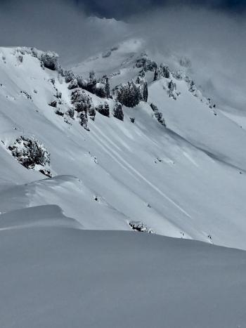
Today, snow surfaces will experience the most intense solar radiation since our recent storm. Over the past two days, roller balls and pinwheels have occurred on steep south facing slopes near and below treeline. Although large and dangerous wet loose avalanches are unlikely today, avoid slopes where evidence of recent pinwheels and roller balls exist.
Icefall is a concern today in upper elevation terrain on the south side of Mount Shasta. Many rock formations are plastered in rime and will likely weaken and shed ice with the incoming solar radiation throughout the day.
Recent Observations
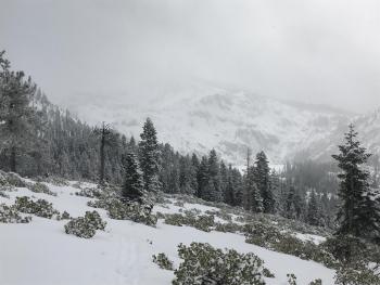
Clouds came in waves yesterday with brief periods of sun. A thin crust has already formed on open steep south facing slopes near and below treeline. East, north and west aspects are still holding cold, dry snow. Light westerly winds continued yesterday with no evidence of blowing snow. Wind lips and small cornices exist along ridgelines, but no wind slabs have been observed in several days. Small dry loose avalanches/sloughing has occurred recently on steep northerly slopes near treeline. Skier triggered sloughs ran far distances but moved slowly and did not entrain much snow. Similar snowpack structure and overall good stability have been observed on Mount Shasta, Mount Eddy and in the Tri Forest Snowmobile Trails area east of the mountain.
Weather and Current Conditions
Weather Summary
Today, expect mostly sunny skies, highs in the lower 40s and light south/southwest winds. Tonight and tomorrow will bring increasing cloud cover as an upper level trough of low-pressure slowly moves over northern California. Strong southerly flow will develop bringing gusty winds and light snowfall tomorrow after 11am. Heavy snowfall is expected Wednesday and Thursday as an atmospheric river event impacts the region.
24 Hour Weather Station Data @ 6:00 AM
| Weather Station | Temp (°F) | Wind (mi/hr) | Snow (in) | Comments | ||||||||
|---|---|---|---|---|---|---|---|---|---|---|---|---|
| Cur | Min | Max | Avg | Avg | Max Gust | Dir | Depth | New | Water Equivalent | Settlement | ||
| Mt. Shasta City (3540 ft) | 28 | 26 | 48 | 36.5 | 0 | N | ||||||
| Sand Flat (6750 ft) | station down | |||||||||||
| Ski Bowl (7600 ft) | 19 | 13.5 | 30.5 | 21 | 74 | 0 | 0 | 2 | ||||
| Gray Butte (8000 ft) | 19 | 14 | 29 | 20 | 5 | 14 | WSW | |||||
| Castle Lake (5870 ft) | station down | |||||||||||
| Mount Eddy (6509 ft) | 18.5 | 12 | 29 | 22.5 | 1 | 6 | WSW | 47 | 0 | 1 | ||
| Ash Creek Bowl (7250 ft) | station down | |||||||||||
| Ash Creek Ridge (7895 ft) | station down |
Two Day Mountain Weather Forecast
Produced in partnership with the Medford NWS
| For 7000 ft to 9000 ft | |||
|---|---|---|---|
|
Monday (4 a.m. to 10 p.m.) |
Monday Night (10 p.m. to 4 a.m.) |
Tuesday (4 a.m. to 10 p.m.) |
|
| Weather | Mostly sunny | Mostly cloudy | Snow likely, mainly after 11am. Mostly cloudy. Chance of precipitation 60%. |
| Temperature (°F) | 35 | 23 | 35 |
| Wind (mi/hr) | S/SE 0-5 mi/hr | S/SE 0-5 mi/hr | S 5-10 mi/hr |
| Precipitation SWE / Snowfall (in) | / 0 | / 0 | / 1-2 |
| For 9000 ft to 11000 ft | |||
| Monday | Monday Night | Tuesday | |
| Weather | Mostly sunny. Wind chill values as low as -7. | Mostly cloudy. Wind chill values as low as -5. | Snow likely, mainly after 11am. Mostly cloudy. Wind chill values as low as -8. Chance of precipitation 60%. |
| Temperature (°F) | 15 | 15 | 21 |
| Wind (mi/hr) | SW 15-20 mi/hr | SW 0 | S/SW 20-30 mi/hr |
| Precipitation SWE / Snowfall (in) | / 0 | / 0 | / 2-4 |
Season Precipitation for Mount Shasta City
| Period | Measured (in) | Normal (in) | Percent of Normal (%) |
|---|---|---|---|
| From Oct 1, 2025 (the wet season) | 14.33 | 33.55 | 43 |
| Month to Date (since Jun 1, 2026) | 3.44 | 4.05 | 85 |
| Year to Date (since Jan 1, 2026) | 8.50 | 18.34 | 46 |

