

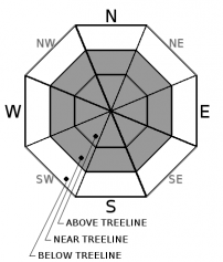
You are here
Avalanche Advisory for 2018-03-22 06:36
- EXPIRED ON March 23, 2018 @ 6:36 amPublished on March 22, 2018 @ 6:36 am
- Issued by Aaron Beverly - Mount Shasta Avalanche Center
Bottom Line
A potent storm will continue to impact the forecast area today and tomorrow. Up to a foot of snow could fall at high elevations. Avalanche danger is CONSIDERABLE above treeline and MODERATE near treeline due to the presence of wind slabs. Below treeline, avalanche danger is LOW.


Avalanche Problem 1: Wind Slab
-
Character ?

-
Aspect/Elevation ?
-
Likelihood ?CertainVery LikelyLikelyPossible
 Unlikely
 -
Size ?HistoricVery LargeLargeSmall

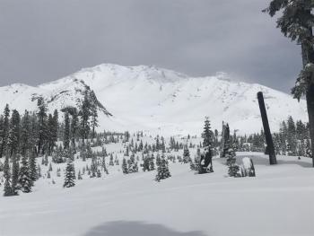
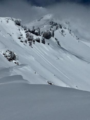
Expect to find wind slabs today above treeline. Strong winds and new snow today will work to continue wind slab growth. Encountering wind slabs near treeline is less likely due to high snow levels, but possible. Wind drifts, shooting cracks, wind eroded snow surfaces, and hollow sounding snow are all signs of the wind slab problem.
Look for wind slabs in leeward terrain near and above treeline. Avoid them by sticking to protected or wind scoured areas. Steer clear of wind loaded slopes 35 degrees and steeper and avoid runout zones.
Forecast Discussion
Below 8000 ft, expect to find rain on snow and mushy new snow. As snow levels drop today, new drier snow will begin to accumulate below treeline.
The amount of snow fallen on the mountain above treeline has not been verified, but based on the amount of water we have received and will receive today, new storm snow could be up to 2 ft. If you go high today in search of it, monitor conditions as you ascend and look for these red flags for avalanche danger:
- Recent avalanche activity.
- Cracking or whoomphing
- Significant snowfall in the last 24 Hours
- Strong winds
Recent Observations
The Old Ski Bowl weather station recorded 1.27 inches of water over the last 24 hours. New snow recorded is 4 in. Water total for the storm starting Tuesday afternoon is 1.51 in. Temperatures remained at or near 32 degrees from 12:00 p.m. yesterday.
SSW-SW winds have averaged 15 mph. Last night winds shifted to the W and kicked up to 25 mi/hr with gusts up to 37 mi/hr.
Observations at Bunny Flat yesterday at 2:00 p.m. saw an inch of new wet snow on the ground and moderate rain. No roller balls or pinwheels were seen.
Snow levels have been near 7500 ft for most of this storm.
Weather and Current Conditions
Weather Summary
A winter storm watch is in effect from late tonight through Friday evening. A cold front will begin to move into the area dropping snow levels to 5700 ft by 11 a.m. Snow levels will continue to drop down to town by tonight.
There is uncertainty in predicted snow amounts. Another 0.69 inches of water could fall today, though the bulk of this looks to occur before snow levels drop. We'll see a break tonight followed by more snow tomorrow. Generous predictions are indicating 6-11 inches today. I suspect you'll see this mostly above treeline.
SW winds will be strong to gale force near and above treeline.
24 Hour Weather Station Data @ 4:00 AM
| Weather Station | Temp (°F) | Wind (mi/hr) | Snow (in) | Comments | ||||||||
|---|---|---|---|---|---|---|---|---|---|---|---|---|
| Cur | Min | Max | Avg | Avg | Max Gust | Dir | Depth | New | Water Equivalent | Settlement | ||
| Mt. Shasta City (3540 ft) | 39 | 36 | 43 | 39.5 | 1 | N | ||||||
| Sand Flat (6750 ft) | station down | |||||||||||
| Ski Bowl (7600 ft) | 30.5 | 28 | 33 | 31 | 76.9 | 4 | 1.27 | 1.3 | ||||
| Gray Butte (8000 ft) | 31 | 27 | 32 | 30.5 | 16 | 37 | SSW | |||||
| Castle Lake (5870 ft) | station down | |||||||||||
| Mount Eddy (6509 ft) | 33 | 30.5 | 35.5 | 34 | 2 | 18 | S | 45.7 | 1 | 1 | ||
| Ash Creek Bowl (7250 ft) | station down | |||||||||||
| Ash Creek Ridge (7895 ft) | station down |
Two Day Mountain Weather Forecast
Produced in partnership with the Medford NWS
| For 7000 ft to 9000 ft | |||
|---|---|---|---|
|
Thursday (4 a.m. to 10 p.m.) |
Thursday Night (10 p.m. to 4 a.m.) |
Friday (4 a.m. to 10 p.m.) |
|
| Weather | Rain and snow showers, becoming all snow after 11 a.m. Chance of precipitation is 100%. | A 50 percent chance of snow after 11 p.m. | Snow, heavy at times. Breezy. Chance of precipitation is 100%. |
| Temperature (°F) | 35 | 19 | 29 |
| Wind (mi/hr) | SW 15-20 mi/hr | SW 10 mi/hr | S 15-20 mi/hr |
| Precipitation SWE / Snowfall (in) | / 6-8 | / <1 | / 8-11 |
| For 9000 ft to 11000 ft | |||
| Thursday | Thursday Night | Friday | |
| Weather | Snow before 11 a.m., then snow showers likely. Windy. Chance of precipitation is 100%. | A 50 percent chance of snow after 11 p.m. Wind chill values as low as -15. Windy. | Snow, heavy at times. Wind chill values as low as -14. Windy. Chance of precipitation is 100%. |
| Temperature (°F) | 24 | 9 | 12 |
| Wind (mi/hr) | SW 40-50 mi/hr | SW 8-11 | SW 40-50 mi/hr |
| Precipitation SWE / Snowfall (in) | / 8-11 | / <1 | / 11-14 |
Season Precipitation for Mount Shasta City
| Period | Measured (in) | Normal (in) | Percent of Normal (%) |
|---|---|---|---|
| From Oct 1, 2025 (the wet season) | 15.22 | 34.04 | 45 |
| Month to Date (since Jun 1, 2026) | 4.33 | 4.54 | 95 |
| Year to Date (since Jan 1, 2026) | 9.39 | 18.83 | 50 |

