

You are here
Avalanche Advisory for 2018-04-13 05:39
- EXPIRED ON April 14, 2018 @ 5:39 amPublished on April 13, 2018 @ 5:39 am
- Issued by Nick Meyers - Shasta-Trinity National Forest
Bottom Line
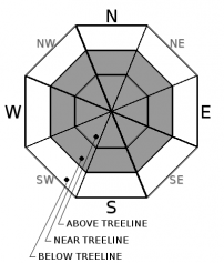
Today, LOW avalanche danger exists below treeline. Near and above treeline, MODERATE danger remains due to the wind slab avalanche problem. Sun-exposed slopes may see some small, loose wet instabilities this afternoon. Ridgelines and any other areas scoured to the old snow surface will be slick and firm. Wear a helmet to protect from falling rime ice off the upper mountain.


Avalanche Problem 1: Wind Slab
-
Character ?

-
Aspect/Elevation ?
-
Likelihood ?CertainVery LikelyLikelyPossible
 Unlikely
 -
Size ?HistoricVery LargeLargeSmall

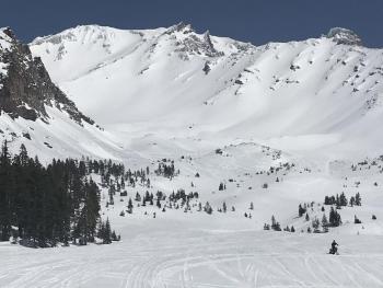
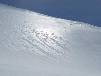
New snow and strong winds have created fresh wind slabs on the right half of the compass near and above treeline. Wind slabs were observed up to 2 feet thick. Use clues like blowing snow, cornices above a slope, drifted snow, ripples in the snow surface, and other wind created features to identify where wind slabs may exist. Avoid those areas in favor of more sheltered slopes where softer snow is also more likely to exist.
Forecast Discussion
A climber already fell off the west aspect of Green Butte ridge a few days ago and slid to the bottom, fortunately unharmed. We can't stress this enough... Beware of hard, slick surfaces along ridgelines and on the upper mountain. Areas where snow has been scoured down to the old snow surface will provide for sporty climbing conditions: a long slide for life is absolutely possible should one slip, trip, fall. Watch for falling rime ice as well from cliffs above. Where a helmet and know how to use your crampons and ice axe!
Recent Observations
Yesterday, a mostly clear morning sky quickly became shrouded with clouds that obscured the Mount Shasta area and upper mountain for most of the day. A donut hole sky allowed for the sun to peak through at times. The cloud deck hovered near 9,000 feet with whiteout conditions above. New snow amounts averaged 6 inches below treeline and 9 inches near and above treeline. Moraine tops and ridgelines were scoured to the hard, slick, old snow surface. Gullies and leeward, easterly aspects held up to 2' drifts. Southwesterly winds dropped lower than usual and were noticable down to 7,700 feet. Blowing snow was widespread throughout the day. Snow surfaces were generally smooth with light texturing and wind sculpting of new snow in exposed areas. Small loose dry point releases were observed below cliff bands.
Weather and Current Conditions
Weather Summary
Clouds will build across southern Oregon and northern California as a weak warm front moves from south to north. Chance of precipitation and clouds will decrease as the day goes on. The next wave of weather is expected to reach land late Saturday morning. Mount Shasta should stay rain free for your activity of choice and daytime highs will be near normal for this time of year. Precipitation will really start to fill in on Saturday night and Sunday. Amounts are light to moderate with snow levels near 4 to 5,000 feet Sunday and 2 to 3,000 feet Monday. Winds will taper for the time being, picking back up Sunday.
24 Hour Weather Station Data @ 3:00 AM
| Weather Station | Temp (°F) | Wind (mi/hr) | Snow (in) | Comments | ||||||||
|---|---|---|---|---|---|---|---|---|---|---|---|---|
| Cur | Min | Max | Avg | Avg | Max Gust | Dir | Depth | New | Water Equivalent | Settlement | ||
| Mt. Shasta City (3540 ft) | 29 | 29 | 46 | 37.5 | 2 | N | ||||||
| Sand Flat (6750 ft) | station down | |||||||||||
| Ski Bowl (7600 ft) | 19.5 | 13.5 | 27 | 22 | 81 | 0 | 0 | 2 | ||||
| Gray Butte (8000 ft) | 20.5 | 12 | 23 | 18.5 | 19 | 49 | NW | |||||
| Castle Lake (5870 ft) | 0 | 0 | 0 | 0 | 0 | 0 | 0 | station down | ||||
| Mount Eddy (6509 ft) | 24 | 16 | 29.5 | 23.5 | 1 | 10 | SE | 40 | 0 | 4 | ||
| Ash Creek Bowl (7250 ft) | station down | |||||||||||
| Ash Creek Ridge (7895 ft) | station down |
Two Day Mountain Weather Forecast
Produced in partnership with the Medford NWS
| For 7000 ft to 9000 ft | |||
|---|---|---|---|
|
Friday (4 a.m. to 10 p.m.) |
Friday Night (10 p.m. to 4 a.m.) |
Saturday (4 a.m. to 10 p.m.) |
|
| Weather | Partly cloudy | Mostly cloudy | Mostly sunny |
| Temperature (°F) | 48 | 32 | 51 |
| Wind (mi/hr) | SW 5 | SW 5 | SW 10 |
| Precipitation SWE / Snowfall (in) | / 0 | / 0 | / 0 |
| For 9000 ft to 11000 ft | |||
| Friday | Friday Night | Saturday | |
| Weather | Partly cloudy | Mostly cloudy | Mostly sunny |
| Temperature (°F) | 25 | 25 | 26 |
| Wind (mi/hr) | NW 10-20 | W 0 | SW 20-30 |
| Precipitation SWE / Snowfall (in) | / 0 | / 0 | / 0 |
Season Precipitation for Mount Shasta City
| Period | Measured (in) | Normal (in) | Percent of Normal (%) |
|---|---|---|---|
| From Oct 1, 2025 (the wet season) | 17.81 | 36.77 | 48 |
| Month to Date (since Jun 1, 2026) | 1.86 | 1.31 | 141 |
| Year to Date (since Jan 1, 2026) | 11.98 | 21.56 | 55 |

