

You are here
Avalanche Advisory for 2018-12-10 06:00
- EXPIRED ON December 11, 2018 @ 6:00 amPublished on December 10, 2018 @ 6:00 am
- Issued by Aaron Beverly - Mount Shasta Avalanche Center
Bottom Line
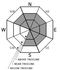
The avalanche danger is MODERATE near and above treeline. Look for small isolated wind slabs on leeward slopes greater than 35 degrees. Avalanche danger is LOW below treeline.


Avalanche Problem 1: Wind Slab
-
Character ?

-
Aspect/Elevation ?
-
Likelihood ?CertainVery LikelyLikelyPossible
 Unlikely
 -
Size ?HistoricVery LargeLargeSmall

With 3 inches of new snow received last night accompanied by westerly winds, you may encounter small isolated wind slabs in leeward terrain. These will unlikely be large enough to bury a person, but stay vigilant nonetheless. Signs of this problem are wind pillows, wind textured snow surfaces, and cornice formation. If uncertainty exists, travel in more wind protected terrain.
Forecast Discussion
Continue to be wary of buried hazards near the surface of our thin snowpack. If climbing, bring an ice axe and crampons with the knowledge to use them. Wear a helmet.
The Mount Shasta Ski Park opens this Wednesday. Come out and partake in the winter fun!
Recent Observations
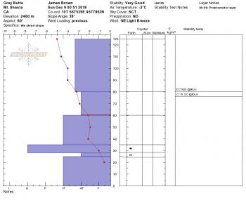
In the last 24 hours we have received close to 3 inches of new snow above 6000 ft. Temperatures have ranged from 26 to 35 degrees. Westerly winds have averaged 11 mi/hr with gusts up to 25.
Conditions on Mount Shasta yesterday:
- Thin crust in sunny areas
- Preserved soft and creamy powder in shady areas
- Light to moderate SW winds
- Stable snow pack
- Buried hazards exist everywhere.
Weather and Current Conditions
Weather Summary
A wave of high pressure moves in today which will keep conditions cool and dry for the next couple of days. Weak frontal systems could bring a bit of precipitation throughout the week, but we may be a too far south to see the benefits. More snow is on the way this weekend. Snow levels should remain near 4000-5000 ft which will help preserve our preciously thin snow pack.
24 Hour Weather Station Data @ 3:00 AM
| Weather Station | Temp (°F) | Wind (mi/hr) | Snow (in) | Comments | ||||||||
|---|---|---|---|---|---|---|---|---|---|---|---|---|
| Cur | Min | Max | Avg | Avg | Max Gust | Dir | Depth | New | Water Equivalent | Settlement | ||
| Mt. Shasta City (3540 ft) | 37 | 34 | 46 | 39 | 1 | N | ||||||
| Sand Flat (6750 ft) | 31 | 29 | 33 | 31 | 28 | 2 | 0.12 | 1 | ||||
| Ski Bowl (7600 ft) | 27 | 26.5 | 33.5 | 30 | 36.1 | 2.7 | 0.32 | 0.8 | ||||
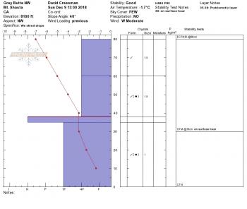
| Gray Butte (8000 ft) | 26.5 | 24 | 30 | 27.5 | 11 | 25 | W | |||||
| Castle Lake (5870 ft) | station down | |||||||||||
| Mount Eddy (6509 ft) | 25.5 | 25.5 | 33.5 | 30 | 1 | 10 | S | 28 | 0 | 0 | ||
| Ash Creek Bowl (7250 ft) | station down | |||||||||||
| Ash Creek Ridge (7895 ft) | station down |
Two Day Mountain Weather Forecast
Produced in partnership with the Medford NWS
| For 7000 ft to 9000 ft | |||
|---|---|---|---|
|
Monday (4 a.m. to 10 p.m.) |
Monday Night (10 p.m. to 4 a.m.) |
Tuesday (4 a.m. to 10 p.m.) |
|
| Weather | Isolated snow showers before 10 a.m. Partly sunny. Chance of precipitation is 20%. | Partly cloudy. | A 50 percent chance of snow after 10 a.m. Partly sunny. Gusty. |
| Temperature (°F) | 34 | 23 | 39 |
| Wind (mi/hr) | NW 4 | N 5 | N 6 |
| Precipitation SWE / Snowfall (in) | / 0 | / 0 | / 0 |
| For 9000 ft to 11000 ft | |||
| Monday | Monday Night | Tuesday | |
| Weather | Scattered snow showers before 10 a.m. Mostly cloudy, then gradually becoming sunny. Windy and gusty. Chance of precipitation is 30%. | Partly cloudy. Wind chill values as low as -6. Windy and gusty. | A 50 percent chance of snow after 10 a.m. Mostly cloudy. Wind chill values as low as -1. Windy and gusty. |
| Temperature (°F) | 19 | 19 | 27 |
| Wind (mi/hr) | NW 10 | N 0 | NW 22 |
| Precipitation SWE / Snowfall (in) | / 0 | / 0 | / 0 |
Season Precipitation for Mount Shasta City
| Period | Measured (in) | Normal (in) | Percent of Normal (%) |
|---|---|---|---|
| From Oct 1, 2025 (the wet season) | 5.16 | 9.45 | 55 |
| Month to Date (since Jun 1, 2026) | 0.43 | 2.09 | 21 |
| Year to Date (since Jan 1, 2026) | 20.44 | 37.45 | 55 |

