

You are here
Avalanche Forecast for 2018-12-21 06:19
- EXPIRED ON December 22, 2018 @ 6:19 amPublished on December 21, 2018 @ 6:19 am
- Issued by Nick Meyers - Shasta-Trinity National Forest
Bottom Line
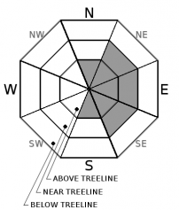
MODERATE danger will continue today for above treeline terrain. A few inches of new snow and moderate W/NW wind will host the possibility of wind slab formation. LOW avalanche danger will exist below and near treeline.


Avalanche Problem 1: Wind Slab
-
Character ?

-
Aspect/Elevation ?
-
Likelihood ?CertainVery LikelyLikelyPossible
 Unlikely
 -
Size ?HistoricVery LargeLargeSmall

Any combination of new snow and wind brings the chance of wind slab avalanches. While likely small and isolated, one may find new wind slabs that have formed from the recent round of new snow (2-3 inches last night) and westerly winds. Snow is available for transport and winds will move whatever snow is available onto leeward aspects. Pay attention to where snow is blowing and use caution on those slopes. A westerly wind will actively load NE-E-SE facing aspects as well as cross-load northerly and southerly aspects. Near and above treeline, keep an eye out for slabs atop softer snow, blowing snow, cornices, wind pillows, shooting cracks and/or smooth, round, hollow sounding snow.
Forecast Discussion
Avalanches large enough to bury, injure or kill a person remain an unlikely event at this time. Small avalanches in isolated areas and/or steep slopes remain possible and could sweep someone off their feet into undesireable terrain. Use normal caution and pay attention to the wind. Even though its not snowing out, wind can load leeward slopes 10 times faster than snow falling from the sky.
Recent Observations
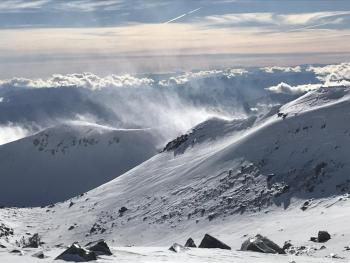
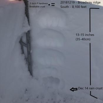
An attempt at a little storm tour yesterday afternoon resulted in wandering around in pea soup, trying to decipher up from down. For the early birds, some decent visibility might have been found, however clouds streamed in and enveloped the mountain by mid-day. Freezing rain, mist and fog tried to be snow at 7,500 feet and was legitimate snow at 8,000 feet at 1430 hours. Measureable precipitation began at 1600 hours and ceased at 2200. Water equivalent totals topped out at .46 inches and resulted in 2-3 inches of new snow at treeline. Through the short lived storm, winds blew SW-W and NW, averaging 15 mi/hr with gusts to 43 mi/hr. Snow surface conditions are variable and skiing and riding conditions were marginal at best. No signs of avalanche danger were observed.
Weather and Current Conditions
Weather Summary
Fog and low clouds will fill valleys this morning, clearing as the day progresses. A weak high pressure ridge builds over the area and will remain in place through Saturday morning. Additional fog is expected in low lying areas during the night and early morning hours, though overall, a couple of clear days are in store. An active pattern is expected Saturday afternoon through Christmas day. A series of weather systems will move into the area and bring rain, snow and gusty winds. As of now, the crystal ball says there is a decent chance for a white Christmas!
24 Hour Weather Station Data @ 3:00 AM
| Weather Station | Temp (°F) | Wind (mi/hr) | Snow (in) | Comments | ||||||||
|---|---|---|---|---|---|---|---|---|---|---|---|---|
| Cur | Min | Max | Avg | Avg | Max Gust | Dir | Depth | New | Water Equivalent | Settlement | ||
| Mt. Shasta City (3540 ft) | 32 | 32 | 45 | 40 | 3 | ESE | ||||||
| Sand Flat (6750 ft) | 24 | 24 | 34 | 31 | 36 | snow depth sensor down | ||||||
| Ski Bowl (7600 ft) | 26 | 26 | 35 | 29.5 | 48 | 2.5 | 0.46 | 1.5 | ||||
| Gray Butte (8000 ft) | 24 | 24 | 34.5 | 28 | 15 | 43 | W | |||||
| Castle Lake (5870 ft) | station down | |||||||||||
| Mount Eddy (6509 ft) | 19 | 18.5 | 35.5 | 30 | 1 | 16 | 31.5 | 0 | 0 | |||
| Ash Creek Bowl (7250 ft) | station down | |||||||||||
| Ash Creek Ridge (7895 ft) | station down |
Two Day Mountain Weather Forecast
Produced in partnership with the Medford NWS
| For 7000 ft to 9000 ft | |||
|---|---|---|---|
|
Friday (4 a.m. to 10 p.m.) |
Friday Night (10 p.m. to 4 a.m.) |
Saturday (4 a.m. to 10 p.m.) |
|
| Weather | Mostly sunny | Partly cloudy | Mostly cloudy with a slight chance of snow. |
| Temperature (°F) | 31 | 24 | 36 |
| Wind (mi/hr) | NW 5-10 | N 5-10 | SE 5-10 |
| Precipitation SWE / Snowfall (in) | / 0 | / 0 | / 0 |
| For 9000 ft to 11000 ft | |||
| Friday | Friday Night | Saturday | |
| Weather | Mostly sunny, windy. | Partly cloudy, windy | Mostly cloudy, slight chance of snow after 10am, windy. |
| Temperature (°F) | 19 | 19 | 22 |
| Wind (mi/hr) | W 20-25 | NW 0 | W 20-25 |
| Precipitation SWE / Snowfall (in) | / 0 | / 0 | / 0 |
Season Precipitation for Mount Shasta City
| Period | Measured (in) | Normal (in) | Percent of Normal (%) |
|---|---|---|---|
| From Oct 1, 2025 (the wet season) | 7.58 | 12.32 | 62 |
| Month to Date (since Jun 1, 2026) | 2.85 | 4.96 | 57 |
| Year to Date (since Jan 1, 2026) | 22.86 | 40.32 | 57 |

