

You are here
Avalanche Forecast for 2018-12-22 06:29
- EXPIRED ON December 23, 2018 @ 6:29 amPublished on December 22, 2018 @ 6:29 am
- Issued by Nick Meyers - Shasta-Trinity National Forest
Bottom Line
LOW avalanche danger and normal caution is advised for all elevations and aspects today. With a storm forecast to move into the area this evening, the avalanche danger may rise to MODERATE tonight, above treeline. Fresh wind slabs, small to medium in size, on S-SE-E facing aspects should be your primary concern. Westerly winds and a few inches of new snow are likely. Additional snow and wind are forecast for the remainder of the weekend as well.


Avalanche Problem 1: Wind Slab
-
Character ?

-
Aspect/Elevation ?
-
Likelihood ?CertainVery LikelyLikelyPossible
 Unlikely
 -
Size ?HistoricVery LargeLargeSmall

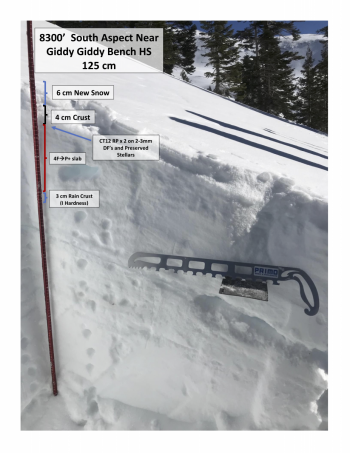
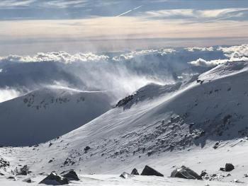
Existing slabs on avalanche prone slopes have been difficult to find as strong SW-W-NW winds have blown most of the available snow for transport off the mountain over the past week. That said, a fresh round of storms will arrive this afternoon. Any combination of new snow and wind brings the chance for wind slab avalanches. Pay attention to where snow is blowing and use caution on those slopes. Most wind loading will occur on S-SE-E facing aspects, near and above treeline, but not limited to. Keep an eye out for slabs atop softer snow, blowing snow, cornices, wind pillows, shooting cracks and/or smooth, round, hollow sounding snow.
Forecast Discussion
Mount Shasta is claiming 45 inches of snow on the ground at 7,700 feet. Coverage overall is good, aside from the exposed, ice and rime encrusted ridgelines. We don't have any persistent, existing weak layers of concern in the snowpack at this point. Avalanche danger will rise and fall this weekend, perhaps several times, with any new storm event and/or post storm wind event. Recent, heavy snow... blowing snow... and recent avalanches are some of the best red flags of avalanche danger to watch out for in our maritime snow climate. When the snow is in question, terrain is the answer. If in doubt, stick to lower angle terrain to stay out of trouble!
Recent Observations
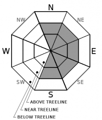
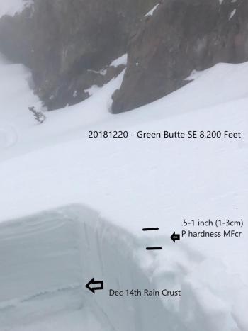
See multiple observations with photos below from the south side of Mount Shasta yesterday. In general:
- Below treeline, a couple inches of new snow rests on top of a supportable, formerly breakable crust. Soft, surfy snow surfaces hosted some of the best riding yesterday.
- Near treeline, wind effects start to become noticeable. Low lying areas may host softer snow while other more exposed, sunny areas are variable, including breakable sun crusts, smooth wind packed powder, scoured ridgelines, chalky gullies/low angle morain concavities.
- Above treeline, light sastrugi features were observed in windy terrain along with scoured, icy ridges and morain tops. Ridgelines are encrusted in ice and rime. Less exposed areas host supportable, wind packed powder.
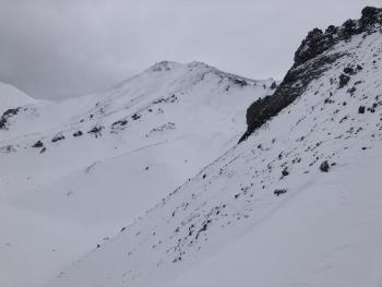
- Yesterday, strong westerly winds hammered terrain above treeline. Low lying drainages were the best way to stay out of the wind and find decent snow surfaces.
- Blowing snow was easily visible and widespread, most sublimating off to the east. No natural or human triggered avalanches were observed. Visibility was perfect. Any blowing snow that stayed on the mountain, collected in gullies and low angle terrain.
- Wind slabs were observed up to several feet thick on S-SE-E aspects, but none on slopes steep enough for an avalanche.
Weather and Current Conditions
Weather Summary
Morning fog and low clouds will greet daylight this morning. Several weather systems begin to move into the area today through Monday. The first will move inland tonight into Sunday. Precipitation will begin to spread across the west side this afternoon and bring light to moderate precipitation amounts and gusty winds (westerly) by tonight. Mount Shasta City probably won't see much for snow but the mountains surrounding could see a couple inches. Snow levels forecasts show 4,000 feet tonight and 4,700 feet Sunday. Rain and mountain snow will continue on Sunday as the front lingers. Monday, a stronger low will move in with moderate to locally heavy rain and snow. Winter weather advisories are in effect already for this second wave of weather. Holiday travelers should be prepared for inclement weather over the passes. Anyone dreaming of a white Christmas might see a dream come true!
24 Hour Weather Station Data @ 4:00 AM
| Weather Station | Temp (°F) | Wind (mi/hr) | Snow (in) | Comments | ||||||||
|---|---|---|---|---|---|---|---|---|---|---|---|---|
| Cur | Min | Max | Avg | Avg | Max Gust | Dir | Depth | New | Water Equivalent | Settlement | ||
| Mt. Shasta City (3540 ft) | 22 | 22 | 40 | 31.5 | 2 | N | ||||||
| Sand Flat (6750 ft) | 16 | 16 | 27 | 21 | 33 | 0 | 0 | 0 | ||||
| Ski Bowl (7600 ft) | 27.5 | 20.5 | 29.5 | 24.5 | 46 | 0 | 0 | 0 | ||||
| Gray Butte (8000 ft) | 30 | 20 | 30 | 25 | 11 | 31 | WNW | |||||
| Castle Lake (5870 ft) | station down | |||||||||||
| Mount Eddy (6509 ft) | 19 | 18.5 | 35.5 | 30 | 1 | 16 | 31.5 | 0 | 0 | |||
| Ash Creek Bowl (7250 ft) | station down | |||||||||||
| Ash Creek Ridge (7895 ft) | station down |
Two Day Mountain Weather Forecast
Produced in partnership with the Medford NWS
| For 7000 ft to 9000 ft | |||
|---|---|---|---|
|
Saturday (4 a.m. to 10 p.m.) |
Saturday Night (10 p.m. to 4 a.m.) |
Sunday (4 a.m. to 10 p.m.) |
|
| Weather | Mostly cloudy, snow likely after 4pm. Chance of precipitation 60%. | Snow likely, mainly before 10pm, cloudy, breezy. Chance of precipitation 60%. | Snow showers, mainly after 10am, windy. Chance of precipitation 80%. |
| Temperature (°F) | 34 | 28 | 33 |
| Wind (mi/hr) | SE 5-10 | S 10-15 | SW 10-15 |
| Precipitation SWE / Snowfall (in) | / < .5 | / 1-2 | / 1 |
| For 9000 ft to 11000 ft | |||
| Saturday | Saturday Night | Sunday | |
| Weather | Mostly cloudy, snow likely, mainly after 4pm, windy. | Snow likely, mainly before 10pm, cloudy, windy. | Snow showers, mainly after 10am, windy. |
| Temperature (°F) | 23 | 20 | 20 |
| Wind (mi/hr) | W 20-25 | W < 1 | W 45-55 |
| Precipitation SWE / Snowfall (in) | / < 1 | / 1-3 | / 1-2 |
Season Precipitation for Mount Shasta City
| Period | Measured (in) | Normal (in) | Percent of Normal (%) |
|---|---|---|---|
| From Oct 1, 2025 (the wet season) | 7.58 | 12.60 | 60 |
| Month to Date (since Jun 1, 2026) | 2.85 | 5.24 | 54 |
| Year to Date (since Jan 1, 2026) | 22.86 | 40.60 | 56 |

