

You are here
Avalanche Forecast for 2018-12-23 06:00
- EXPIRED ON December 24, 2018 @ 6:00 amPublished on December 23, 2018 @ 6:00 am
- Issued by Aaron Beverly - Mount Shasta Avalanche Center
Bottom Line
The avalanche danger is LOW at all elevations. Exercise normal caution and look for small wind slabs in isolated areas. A skiff of snow will freshen snow surfaces today. Look for a legitimate Shasta snow storm on Monday to bring several inches of snow to elevations above 4800 ft.


Avalanche Problem 1: Wind Slab
-
Character ?

-
Aspect/Elevation ?
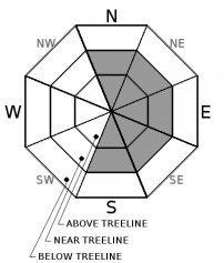
-
Likelihood ?CertainVery LikelyLikelyPossible
 Unlikely
 -
Size ?HistoricVery LargeLargeSmall

If generous predictions materialize, upper elevations may receive up to 3 inches of new snow. Combined with strong W winds, thin wind slabs could form on easterly slopes. These will be small, but could catch an unaware rider off guard.
Signs of wind slabs are blowing snow, cornices, wind pillows, shooting cracks and/or smooth, round, hollow sounding snow. Be suspicious of any steep slope with recent deposits of wind drifted snow.
Forecast Discussion
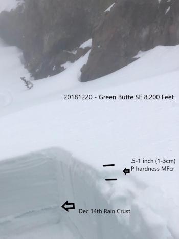
Mount Shasta has 47 inches of snow on the ground at 7,700 feet. Coverage overall is good, aside from the exposed ice and rime encrusted ridgelines. We don't have any persistent weak layers of concern in the snowpack. Expect avalanche danger to rise tomorrow with a significant incoming storm.
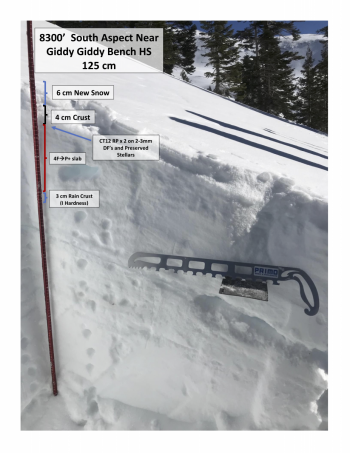
Recent Observations
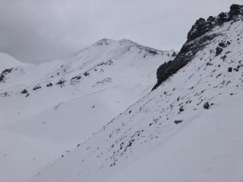
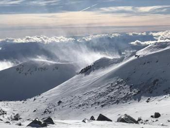
No significant signs of instability have been observed at any elevation. No notable wind slabs have been seen in start zones. Snow surfaces above treeline present a mixture of wind scoured ridges, sun crusts, rimed rock and snow, packed powder, sastrugis, and chalky gullies. It's survival skiing interspersed with a few great turns. Look for those below treeline, in ravines, and on low angle terrain. Not much snow remains for transport. See observations below for details.
Weather and Current Conditions
Weather Summary
A weak front will pass through today bringing a meager amount of snow. Point forecasts are generously predicting up to 3 inches of snow, but less than an inch seems more realistic at all elevations.
Tomorrow's front is shaping up to offer a legit Shasta snow storm with promising snow levels and several inches of snow. A winter weather advisory will be in effect from 4 a.m. to 10 p.m. tomorrow.
Snow levels today will be 5000 ft then dropping to 4800 ft tonight and tomorrow.
24 Hour Weather Station Data @ 4:00 AM
| Weather Station | Temp (°F) | Wind (mi/hr) | Snow (in) | Comments | ||||||||
|---|---|---|---|---|---|---|---|---|---|---|---|---|
| Cur | Min | Max | Avg | Avg | Max Gust | Dir | Depth | New | Water Equivalent | Settlement | ||
| Mt. Shasta City (3540 ft) | 34 | 22 | 35 | 31.5 | 1 | N | ||||||
| Sand Flat (6750 ft) | 32 | 17 | 32 | 28 | 32 | 0 | 0 | 0 | ||||
| Ski Bowl (7600 ft) | 30.5 | 28 | 36 | 31.5 | 47 | 1 | 0.12 | 0 | ||||
| Gray Butte (8000 ft) | 29.5 | 27 | 34 | 30.5 | 13 | 37 | WNW | |||||
| Castle Lake (5870 ft) | station down | |||||||||||
| Mount Eddy (6509 ft) | 34 | 23 | 37.5 | 33 | 1 | 11 | 33.8 | 0 | 0 | |||
| Ash Creek Bowl (7250 ft) | station down | |||||||||||
| Ash Creek Ridge (7895 ft) | station down |
Two Day Mountain Weather Forecast
Produced in partnership with the Medford NWS
| For 7000 ft to 9000 ft | |||
|---|---|---|---|
|
Sunday (4 a.m. to 10 p.m.) |
Sunday Night (10 p.m. to 4 a.m.) |
Monday (4 a.m. to 10 p.m.) |
|
| Weather | Snow showers. Gusty. Chance of precipitation is 80%. | A chance of snow showers before 4 a.m., then snow after 4 a.m. Chance of precipitation is 80%. | Snow. Gusty. Chance of precipitation is 100%. |
| Temperature (°F) | 34 | 28 | 34 |
| Wind (mi/hr) | SW 10-15 | SW 10-15 | SW 10-15 |
| Precipitation SWE / Snowfall (in) | / < 0.5 | / < 0.5 | / 4-7 |
| For 9000 ft to 11000 ft | |||
| Sunday | Sunday Night | Monday | |
| Weather | Snow showers. Low wind chills. Windy and gusty. Chance of precipitation is 80%. | A 40 percent chance of snow showers. Mostly cloudy. Low wind chills. Windy and gusty. | Snow. Low wind chills. Windy and gusty. Chance of precipitation is 100%. |
| Temperature (°F) | 34 | 28 | 34 |
| Wind (mi/hr) | W 30-35 | W 1 | SW 35-40 |
| Precipitation SWE / Snowfall (in) | / 1 | / < 0.5 | / 7-11 |
Season Precipitation for Mount Shasta City
| Period | Measured (in) | Normal (in) | Percent of Normal (%) |
|---|---|---|---|
| From Oct 1, 2025 (the wet season) | 7.58 | 12.88 | 59 |
| Month to Date (since Jun 1, 2026) | 2.85 | 5.52 | 52 |
| Year to Date (since Jan 1, 2026) | 22.86 | 40.88 | 56 |

