

You are here
Avalanche Forecast for 2018-12-24 06:30
- EXPIRED ON December 25, 2018 @ 6:30 amPublished on December 24, 2018 @ 6:30 am
- Issued by Aaron Beverly - Mount Shasta Avalanche Center
Bottom Line
Avalanche danger will rise to CONSIDERABLE above treeline today as inches of new snow combine with wind to create fresh windslabs. Evaluate the snowpack and terrain carefully today. Avoid leeward slopes greater than 35 degrees. Avalanche danger is LOW below treeline.


Avalanche Problem 1: Wind Slab
-
Character ?

-
Aspect/Elevation ?
-
Likelihood ?CertainVery LikelyLikelyPossible
 Unlikely
 -
Size ?HistoricVery LargeLargeSmall

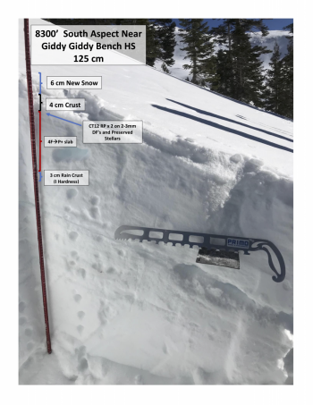
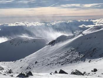
Several inches of new snow combined with moderate to strong winds will cause wind slabs to form on leeward slopes. Winds will start from the S then shift from the W and N. Snow surfaces are so variable, it is hard to say if an ideal bed surface is available for snow to slide on. A widespread crust under about an inch or two of soft snow was encountered on Gray Butte yesterday which could provide the right recipe for an avalanche provided a wind slab forms on top.
A new storm should always raise your awareness. Exercise caution near slopes greater than 35 degrees and be looking for signs of the wind slab problem:
- Blowing snow
- Cornices
- Wind pillows
- Shooting cracks
- Hollow sounding snow
Forecast Discussion
Today's avalanche danger will depend on how much snow actually falls and how much of it gets blown into starting zones. There is uncertainty in these predictions so pay close attention to actual conditions in the backcountry. Expect avalanche danger to be MODERATE to CONSIDERABLE near and above treeline.
If you venture out, keep in mind the 5 obvious signs of avalanche danger:
- Recent avalanche activity
- Cracking, blocking, or whoomphing
- Significant snowfall in 24 hours *
- Strong winds *
- Rapid warming
* Forecasts are predicting these signs today.
Recent Observations
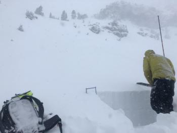
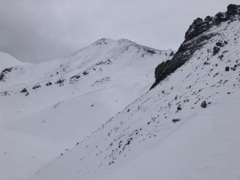
No change in conditions was seen yesterday from the day prior. Snow surfaces are a mixed bag of wind scoured ridges, sun crusts, rimed rock and snow, packed powder, wind boards, sastrugis, and chalky gullies.
On Gray Butte, about an 1-2 inches of moist to dry snow sits atop a widespread supportable crust. Skiing on low angle terrain was fast and almost fun if not for the poor visibility.
Small cornices and wind pillows were unreactive to ski cuts. No notable signs of wind slabs were seen.
Weather and Current Conditions
Weather Summary
A winter weather advisory will be in effect until 10 p.m. tonight. Snow levels will start at 4900 ft, then drop to 4000 ft tonight and 3500 ft tomorrow. Winds will start from the S and gradually shift to W and N. Winds will be moderate to strong near and above treeline during the bulk of today's storm.
There is some variability in forecasts for snow amounts, but expect at least 4-7 inches today above 4900 ft and up to 6-10 inches above treeline.
A ridge of high pressure moves through on Christmas Day bringing cold and mostly sunny conditions.
24 Hour Weather Station Data @ 4:00 AM
| Weather Station | Temp (°F) | Wind (mi/hr) | Snow (in) | Comments | ||||||||
|---|---|---|---|---|---|---|---|---|---|---|---|---|
| Cur | Min | Max | Avg | Avg | Max Gust | Dir | Depth | New | Water Equivalent | Settlement | ||
| Mt. Shasta City (3540 ft) | 40 | 33 | 41 | 38.5 | 0 | N | ||||||
| Sand Flat (6750 ft) | 28 | 28 | 33 | 31 | 33 | 0 | .04 | 1 | ||||
| Ski Bowl (7600 ft) | 24 | 24 | 30 | 26.5 | 46.5 | 0 | 0.02 | 0 | ||||
| Gray Butte (8000 ft) | 23 | 23 | 29 | 25.5 | 15 | 31 | WNW | |||||
| Castle Lake (5870 ft) | station down | |||||||||||
| Mount Eddy (6509 ft) | 29.5 | 26.5 | 33 | 30 | 1 | 7 | WSW | 32 | 0 | 0 | ||
| Ash Creek Bowl (7250 ft) | station down | |||||||||||
| Ash Creek Ridge (7895 ft) | station down |
Two Day Mountain Weather Forecast
Produced in partnership with the Medford NWS
| For 7000 ft to 9000 ft | |||
|---|---|---|---|
|
Monday (4 a.m. to 10 p.m.) |
Monday Night (10 p.m. to 4 a.m.) |
Tuesday (4 a.m. to 10 p.m.) |
|
| Weather | Snow. The snow could be heavy at times. Breezy and gusty. Chance of precipitation is 100%. | A 40 percent chance of snow showers. Mostly cloudy. | A 30 percent chance of snow showers before 10 a.m. Mostly sunny. |
| Temperature (°F) | 33 | 24 | 30 |
| Wind (mi/hr) | S 15-20 | W 5-10 | NW 15-20 |
| Precipitation SWE / Snowfall (in) | / 4-7 | / 1-2 | / 0 |
| For 9000 ft to 11000 ft | |||
| Monday | Monday Night | Tuesday | |
| Weather | Snow. The snow could be heavy at times. Windy and gusty. Chance of precipitation is 100%. | A 40 percent chance of snow showers. Mostly cloudy. Below zero wind chills. Windy and gusty. | A 30 percent chance of snow showers before 10am. Mostly sunny. Windy and gusty. Below zero wind chills. |
| Temperature (°F) | 25 | 17 | 25 |
| Wind (mi/hr) | SW 40-45 | NW 6-10 | N 40-45 |
| Precipitation SWE / Snowfall (in) | / 6-10 | / 1-2 | / 0 |
Season Precipitation for Mount Shasta City
| Period | Measured (in) | Normal (in) | Percent of Normal (%) |
|---|---|---|---|
| From Oct 1, 2025 (the wet season) | 7.58 | 13.15 | 58 |
| Month to Date (since Jun 1, 2026) | 2.85 | 5.79 | 49 |
| Year to Date (since Jan 1, 2026) | 22.86 | 41.15 | 56 |

