

You are here
Avalanche Forecast for 2018-12-25 06:30
- EXPIRED ON December 26, 2018 @ 6:30 amPublished on December 25, 2018 @ 6:30 am
- Issued by Aaron Beverly - Mount Shasta Avalanche Center
Bottom Line
Avalanche danger will be CONSIDERABLE above treeline if winds verify at predicted levels. Over a foot of new snow should raise your awareness of wind slab and storm slab problems. Evaluate the snowpack and terrain carefully today. When in doubt, avoid slopes greater than 35 degrees.


Avalanche Problem 1: Wind Slab
-
Character ?

-
Aspect/Elevation ?
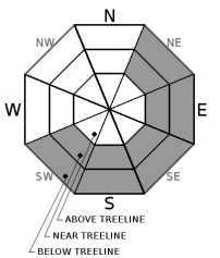
-
Likelihood ?CertainVery LikelyLikelyPossible
 Unlikely
 -
Size ?HistoricVery LargeLargeSmall

In the last 24 hours, winds have remained light. Today, winds will increase to moderate and strong above treeline. Wind slabs could grow to at least a couple of feet in thickness. Stay aware of this problem today if traveling near or above treeline. It is usually Shasta's number one avalanche problem.
A new storm with over a foot of snow combined with wind should always raise your awareness. Exercise caution near slopes greater than 35 degrees and be looking for signs of the wind slab problem:
- Blowing snow
- Cornices
- Wind pillows
- Shooting cracks
- Hollow sounding snow
Avalanche Problem 2: Storm Slab
-
Character ?

-
Aspect/Elevation ?
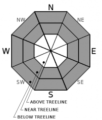
-
Likelihood ?CertainVery LikelyLikelyPossible
Unlikely
-
Size ?HistoricVery LargeLargeSmall
Signficant snow fall and light winds may indicate the existence of a storm slab problem below and near treeline.
Storm slabs may form when new snow consolidates over a weak interface. These commonly form during periods of light or no wind. Find them in sheltered areas. They can occur on any steep open slope, and are often found on several aspects at the same time. Storm slab problems typically last between a few hours and few days.
Forecast Discussion
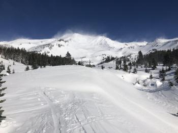
Yes. Conditions will be epic today. You may imagine yourself a star of a ski movie. But remember that close to 14 inches of new snow has fallen in the last 24 hours. This is a red flag in the avalanche world. So are strong winds. Keep your guard up and evaluate snow and terrain carefully. Be wary of slopes greater than 35 degrees.
If you venture out, keep in mind the 5 obvious signs of avalanche danger:
- Recent avalanche activity
- Cracking, blocking, or whoomphing
- Significant snowfall in 24 hours *
- Strong winds **
- Rapid warming
* - this has happened.
** - predicted for today.
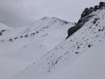
Recent Observations
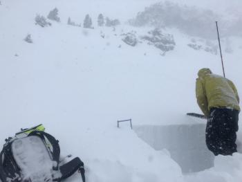
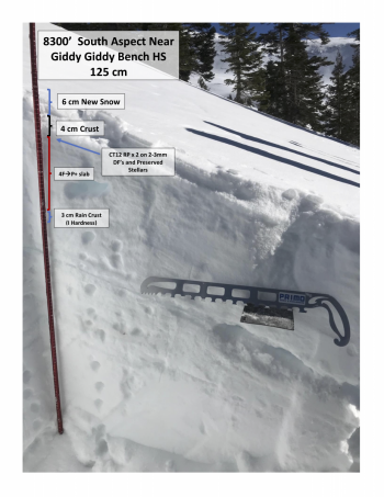
Close to 14 inches of snow fell yesterday near the Old Ski Bowl weather station. Winds were mostly out of the west averaging 10 mi/hr, gusting up to 20 mi/hr.
Though conditions near and above treeline were deep, no signs of instabilities were observed. Column tests produced no notable results. No wind effects were seen. Snowpack displayed right side up layers.
Weather and Current Conditions
Weather Summary
A ridge of high pressure moves through today bringing cold and clear conditions. Above treeline strong north winds at 30-40 mi/hr are expected. The rest of the week looks mostly cool, dry, and clear.
24 Hour Weather Station Data @ 6:00 AM
| Weather Station | Temp (°F) | Wind (mi/hr) | Snow (in) | Comments | ||||||||
|---|---|---|---|---|---|---|---|---|---|---|---|---|
| Cur | Min | Max | Avg | Avg | Max Gust | Dir | Depth | New | Water Equivalent | Settlement | ||
| Mt. Shasta City (3540 ft) | 40 | 33 | 41 | 38.5 | 0 | N | ||||||
| Sand Flat (6750 ft) | 26 | 25 | 32 | 29 | 1 | spurious snow depths | ||||||
| Ski Bowl (7600 ft) | 29.5 | 22.5 | 33.5 | 26.5 | 55.5 | 12.5 | 1.77 | 4.5 | ||||
| Gray Butte (8000 ft) | 20.5 | 20.5 | 26.5 | 24 | 9 | 31 | W | |||||
| Castle Lake (5870 ft) | station down | |||||||||||
| Mount Eddy (6509 ft) | 24.5 | 24.5 | 30.5 | 28 | 1 | 14 | SSE | 44.8 | ||||
| Ash Creek Bowl (7250 ft) | station down | |||||||||||
| Ash Creek Ridge (7895 ft) | station down |
Two Day Mountain Weather Forecast
Produced in partnership with the Medford NWS
| For 7000 ft to 9000 ft | |||
|---|---|---|---|
|
Tuesday (4 a.m. to 10 p.m.) |
Tuesday Night (10 p.m. to 4 a.m.) |
Wednesday (4 a.m. to 10 p.m.) |
|
| Weather | A 30 percent chance of snow showers, mainly before 10 a.m. Mostly sunny. | Partly cloudy. | A 20 percent chance of snow showers after 10 a.m. Mostly sunny. |
| Temperature (°F) | 32 | 23 | 34 |
| Wind (mi/hr) | Northwest 10-15 | Northwest 10-15 | Northwest 5-10 |
| Precipitation SWE / Snowfall (in) | / 0 | / 0 | / 0 |
| For 9000 ft to 11000 ft | |||
| Tuesday | Tuesday Night | Wednesday | |
| Weather | A 30 percent chance of snow showers, mainly before 10 a.m. Mostly sunny. Windy and gusty. Wind chills below zero. | Partly cloudy. Windy and gusty. Wind chills below zero. | A 20 percent chance of snow showers after 10 a.m. Mostly sunny. Windy and gusty. Wind chills below zero. |
| Temperature (°F) | 25 | 24 | 25 |
| Wind (mi/hr) | North 30-40 | North 0 | Northwest 30-40 |
| Precipitation SWE / Snowfall (in) | / 0 | / 0 | / 0 |
Season Precipitation for Mount Shasta City
| Period | Measured (in) | Normal (in) | Percent of Normal (%) |
|---|---|---|---|
| From Oct 1, 2025 (the wet season) | 8.33 | 13.41 | 62 |
| Month to Date (since Jun 1, 2026) | 3.60 | 6.05 | 60 |
| Year to Date (since Jan 1, 2026) | 23.61 | 41.41 | 57 |

