

You are here
Avalanche Forecast for 2018-12-26 06:00
- EXPIRED ON December 27, 2018 @ 6:00 amPublished on December 26, 2018 @ 6:00 am
- Issued by Aaron Beverly - Mount Shasta Avalanche Center
Bottom Line
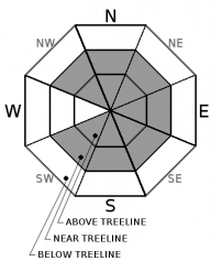
Avalanche danger is MODERATE near and above treeline. Over a foot of snow has disappeared above treeline due to strong north winds. Look for it on the lee side of ridges. Wind slabs have formed and may continue to do so. When in doubt, avoid slopes greater than 35 degrees. Avalanche danger is LOW below treeline.


Avalanche Problem 1: Wind Slab
-
Character ?

-
Aspect/Elevation ?
-
Likelihood ?CertainVery LikelyLikelyPossible
 Unlikely
 -
Size ?HistoricVery LargeLargeSmall

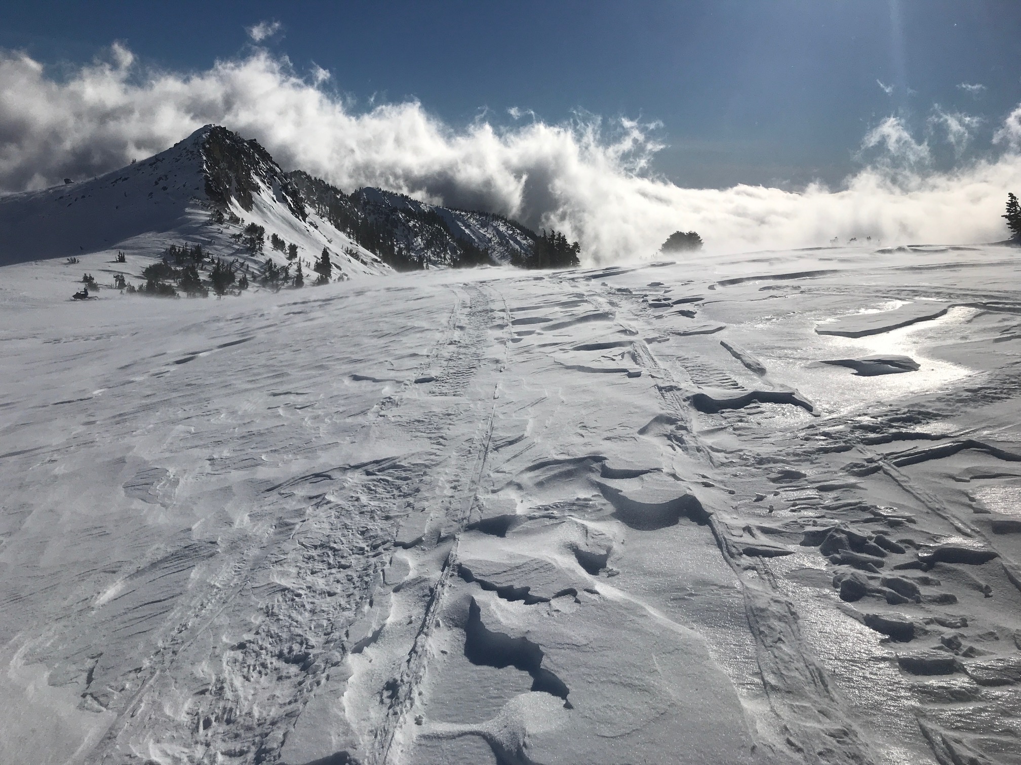
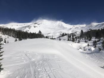
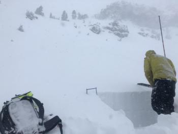
Strong to extreme northerly winds blew the new Christmas Eve snow for several hours yesterday. Similar winds are expected to continue until Friday. These types of winds are not as productive in producing wind slabs in classic avalanche start zones. They tend to sublimate surface snow, blow it off the mountain, or deposit it into gullies and onto low angle terrain. Nevertheless, close to 12 inches of new snow has disappeared. Look for it on the lee side of ridges. If you find it, exercise caution. A couple of small natural wind slab avalanches were observed yesterday. Human triggered avalanches will be possible today.
Exercise caution near slopes greater than 35 degrees and be looking for signs of the wind slab problem:
- Blowing snow
- Cornices
- Wind pillows
- Shooting cracks
- Hollow sounding snow
Forecast Discussion
Today's avalanche danger is MODERATE near and above treeline. MODERATE means there are heightened avalanche conditions on specific terrain features. Evaluate snow and terrain carefully. Natural avalanches are unlikely but human-triggered avalanches are possible. You may be able to trigger small avalanches on leeward slopes.
Recent Observations
Strong to gale force north winds hammered the mountain yesterday for several hours. Much of the new snow was blown away, sublimated, or was displaced into low angle terrain. Snow surfaces are highly wind affected near and above treeline. Don't expect to find much of the 14 inches of Christmas Eve snow left near and above treeline.
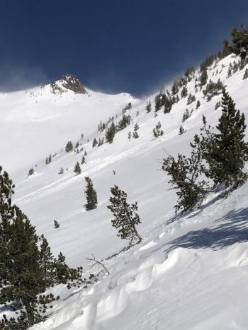
No signs of a storm slab problem were observed. A couple of small D1 wind slab avalanches were observed in Giddy Giddy Gulch and above Hidden Valley.
It appears a temperature inversion may have occured yesterday. Temperatures at the Old Ski Bowl topped out at 40 degrees whereas temperatures at Sand Flat never surpassed freezing.
Weather and Current Conditions
Weather Summary
Strong northwest winds will continue to hammer the alpine regions of the mountain today through Friday. We may receive a skiff of snow tonight, but expect mostly dry cold conditions over the next 3 days. Though there is some variability in weather models, the extended forecast shows the region entering a relatively dry phase compared to earlier this week.
24 Hour Weather Station Data @ 4:00 AM
| Weather Station | Temp (°F) | Wind (mi/hr) | Snow (in) | Comments | ||||||||
|---|---|---|---|---|---|---|---|---|---|---|---|---|
| Cur | Min | Max | Avg | Avg | Max Gust | Dir | Depth | New | Water Equivalent | Settlement | ||
| Mt. Shasta City (3540 ft) | 25 | 24 | 41 | 33.5 | 4 | N | ||||||
| Sand Flat (6750 ft) | 19 | 18 | 29 | 23 | 42.5 | 0 | 0.08 | 0 | ||||
| Ski Bowl (7600 ft) | 31.5 | 21.5 | 39.5 | 31.5 | 52.6 | 9 | 0.02 | 5.8 | ||||
| Gray Butte (8000 ft) | 27.5 | 20.5 | 34.5 | 27 | 14 | 67 | N | |||||
| Castle Lake (5870 ft) | station down | |||||||||||
| Mount Eddy (6509 ft) | 30 | 22 | 30 | 25 | 2 | 10 | SSE | 43.7 | 0 | 1 | ||
| Ash Creek Bowl (7250 ft) | station down | |||||||||||
| Ash Creek Ridge (7895 ft) | station down |
Two Day Mountain Weather Forecast
Produced in partnership with the Medford NWS
| For 7000 ft to 9000 ft | |||
|---|---|---|---|
|
Wednesday (4 a.m. to 10 p.m.) |
Wednesday Night (10 p.m. to 4 a.m.) |
Thursday (4 a.m. to 10 p.m.) |
|
| Weather | A 20 percent chance of snow after 10 a.m. Mostly sunny. | A 30 percent chance of snow showers, mainly before 4 a.m. Blustery. | A 20 percent chance of snow showers before 10 a.m. Mostly sunny. Blustery. |
| Temperature (°F) | 35 | 24 | 30 |
| Wind (mi/hr) | Northwest 5-10 | Northwest 10-15 | North 10-15 |
| Precipitation SWE / Snowfall (in) | / 0 | / < 0.5 | / 0 |
| For 9000 ft to 11000 ft | |||
| Wednesday | Wednesday Night | Thursday | |
| Weather | A 20 percent chance of snow after 10 a.m. Mostly sunny. Windy and gusty. Low wind chills. | A 30 percent chance of snow showers. Mostly cloudy. Windy and gusty. Low wind chills. | A 30 percent chance of snow showers before 10 a.m. Mostly sunny and cold. Windy and gusty. Low wind chills. |
| Temperature (°F) | 23 | 9 | 10 |
| Wind (mi/hr) | Northwest 30-35 | Northwest 0 | Northwest 40-50 |
| Precipitation SWE / Snowfall (in) | / 0 | / < 0.5 | / 0 |
Season Precipitation for Mount Shasta City
| Period | Measured (in) | Normal (in) | Percent of Normal (%) |
|---|---|---|---|
| From Oct 1, 2025 (the wet season) | 8.39 | 13.67 | 61 |
| Month to Date (since Jun 1, 2026) | 3.66 | 6.31 | 58 |
| Year to Date (since Jan 1, 2026) | 23.67 | 41.67 | 57 |

