

You are here
Avalanche Forecast for 2018-12-28 06:09
- EXPIRED ON December 29, 2018 @ 6:09 amPublished on December 28, 2018 @ 6:09 am
- Issued by Nick Meyers - Shasta-Trinity National Forest
Bottom Line
LOW avalanche danger exists for all aspects and elevations. Natural and human triggered avalanches of consequence are unlikely. Watch for small avalanches in isolated areas or extreme terrain. Northerly winds will continue to blow near and above treeline today.


Avalanche Problem 1: Wind Slab
-
Character ?

-
Aspect/Elevation ?
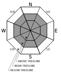
-
Likelihood ?CertainVery LikelyLikelyPossible
 Unlikely
 -
Size ?HistoricVery LargeLargeSmall

Strong northerly winds will continue near and above treeline. Existing wind slabs remain difficult to trigger. Much of the snow available for transport as been stripped away. Watch for small, new wind slabs in isolated areas, extreme terrain, and/or small pockets in protected, steep couloirs.
Signs of a wind slab problem:
- Blowing snow
- Cornices
- Wind pillows
- Shooting cracks
- Hollow sounding snow
Forecast Discussion
We're feeling a bit like a broken record these days, or in other words, message fatigue. If you've followed the forecast this season, the wind slab avalanche problem and northerly winds have been talked about... a lot. This makes sense as Mount Shasta sticks up thousands of feet higher than any other terrain in the area. Despite our repetitious messages, keep your situational awareness up out there.
Recent Observations
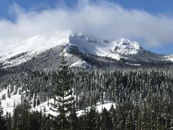
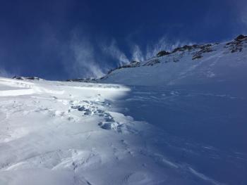
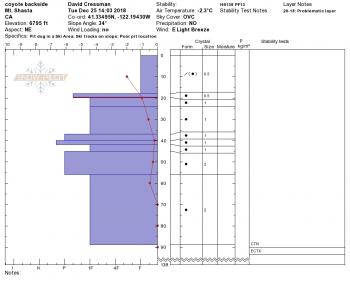
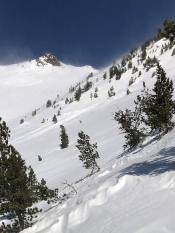
A cold and windy day on the east side of the forecast area yesterday, despite clear skies and sunshine. Northerly wind continued to batter near and above treeline terrain. The entire east aspect of Mount Shasta looked mostly scoured from afar, judging by the salt and pepper morain tops and exposed faces. Leeward gullies facing E-SE held some snow. A large, wide crown line (D2-3) looked barely visible on the Hotlum/Wintun snowfield. Our position was near Ash Creek Butte. The large avalanche path down the east side of Ash Creek Butte held old avalanche debris in the runout zone. A wide spread, thin sun crust seems to dominate most snow surfaces up to 8,000 feet out there. Overall, a right side up snowpack with good stability was observed with 70cm of snow above the 12/13 rain crust. Total height of snow averaged 170cm. Large, thick wind slabs were observed in on many leeward, SW-S-SE aspects near and above treeline, though triggering them would be very difficult. Some minor cracking along slab edges was possible, but not notable. High winds have swept most available snow for transport down into lower lying areas.
Weather and Current Conditions
Weather Summary
Benign weather is in store for the foreseable future. Valleys will host morning fog. The mountains will be windy and mostly clear with slightly warmer temperatures. Saturday night brings a slight chance of light precipitation, nothing to get too excited about. Long term, next Thursday another front moves in.
24 Hour Weather Station Data @ 4:00 AM
| Weather Station | Temp (°F) | Wind (mi/hr) | Snow (in) | Comments | ||||||||
|---|---|---|---|---|---|---|---|---|---|---|---|---|
| Cur | Min | Max | Avg | Avg | Max Gust | Dir | Depth | New | Water Equivalent | Settlement | ||
| Mt. Shasta City (3540 ft) | 25 | 24 | 41 | 33.5 | 4 | N | ||||||
| Sand Flat (6750 ft) | 16 | 14 | 26 | 21 | 41 | 0 | 0 | 0 | ||||
| Ski Bowl (7600 ft) | 29 | 17 | 33.5 | 25 | 49 | 0 | 0 | 2 | ||||
| Gray Butte (8000 ft) | 18.5 | 15.5 | 30 | 23 | 22 | 61 | NNE | |||||
| Castle Lake (5870 ft) | station down | |||||||||||
| Mount Eddy (6509 ft) | 23.5 | 18 | 23.5 | 20 | 3 | 15 | SE | 41 | 0 | 0 | ||
| Ash Creek Bowl (7250 ft) | station down | |||||||||||
| Ash Creek Ridge (7895 ft) | station down |
Two Day Mountain Weather Forecast
Produced in partnership with the Medford NWS
| For 7000 ft to 9000 ft | |||
|---|---|---|---|
|
Friday (4 a.m. to 10 p.m.) |
Friday Night (10 p.m. to 4 a.m.) |
Saturday (4 a.m. to 10 p.m.) |
|
| Weather | Mostly sunny, breezy | Partly cloudy | Mostly sunny, slight chance of rain and snow after 4pm |
| Temperature (°F) | 32 | 28 | 39 |
| Wind (mi/hr) | North 10-15 | North 5-10 | North 5-10 |
| Precipitation SWE / Snowfall (in) | / 0 | / 0 | / 0 |
| For 9000 ft to 11000 ft | |||
| Friday | Friday Night | Saturday | |
| Weather | Mostly sunny, windy | Partly cloudy, windy | Mostly sunny, slight chance of snow after 4pm, windy |
| Temperature (°F) | 24 | 24 | 28 |
| Wind (mi/hr) | North 35-40 | North 0 | Northwest 20-25 |
| Precipitation SWE / Snowfall (in) | / 0 | / 0 | / 0 |
Season Precipitation for Mount Shasta City
| Period | Measured (in) | Normal (in) | Percent of Normal (%) |
|---|---|---|---|
| From Oct 1, 2025 (the wet season) | 8.41 | 14.19 | 59 |
| Month to Date (since Jun 1, 2026) | 3.68 | 6.83 | 54 |
| Year to Date (since Jan 1, 2026) | 23.69 | 42.19 | 56 |

