

You are here
Avalanche Forecast for 2018-12-29 06:22
- EXPIRED ON December 30, 2018 @ 6:22 amPublished on December 29, 2018 @ 6:22 am
- Issued by Nick Meyers - Shasta-Trinity National Forest
Bottom Line
LOW avalanche danger and normal caution is advised today. Natural and human triggered avalanches are unlikely. Extremely icy slopes are present on Mount Shasta, making for near impossible self-arrest in steeper terrain. A slip and fall would be devastating. Be careful. A weak storm tonight will bring windy conditions and a trace of snow to higher terrain.


Avalanche Problem 1: Normal Caution
-
Character ?

-
Aspect/Elevation ?
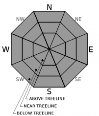
-
Likelihood ?CertainVery LikelyLikelyPossible
 Unlikely
 -
Size ?HistoricVery LargeLargeSmall

Normal caution is advised for the entire forecast area. Watch out for icy slopes and exposed rocks in some areas. Wind slabs are out there but have been very difficult to trigger. Most of the snow available for transport has blown away due to extreme northerly winds over the past week.
Forecast Discussion
For the wet season beginning on October 1st, Mount Shasta City has measured 8.41 inches of water, normal rests at 14.45 inches, putting us at 58 percent of normal.For the month of December, 3.68 inches of water has been recorded, normal is 7.09 which is 52 percent. Snow depths on the mountain and the east side average 40 to 50 inches, aside from scoured ridgelines and moraine tops. The west side (Castle Lake and Eddies) host less snow, average depths about a foot less.The avalanche danger is set on low for the time being. Hunker down, clean up the holiday carnage and prep the equipment for winters next round of high flying snow action, later next week.
Recent Observations
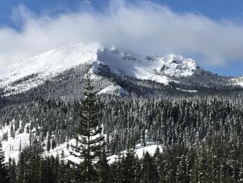
Yesterday was slightly warmer, albeit still chilly. The forecast area is hosting a variety of conditions. On the big mountain, snow surfaces are variable with hard, chocky snow in the lower gullies, breakable crust scattered about on more southerly aspects and some bulletproof, ice encrusted ridgelines and exposed westerly faces. On the west side of the forecast area in the Eddy Range, a solid snowpack structure was observed with average snow heights of 120-130cm (+/- 50 inches). By and large, while coverage is decent, Mount Shasta, Castle and the Eddies are hosting mostly scoured terrain with some form of a crust and/or hard wind effected snow. Crusts will come in the form of paper thin to knee busting breakable.
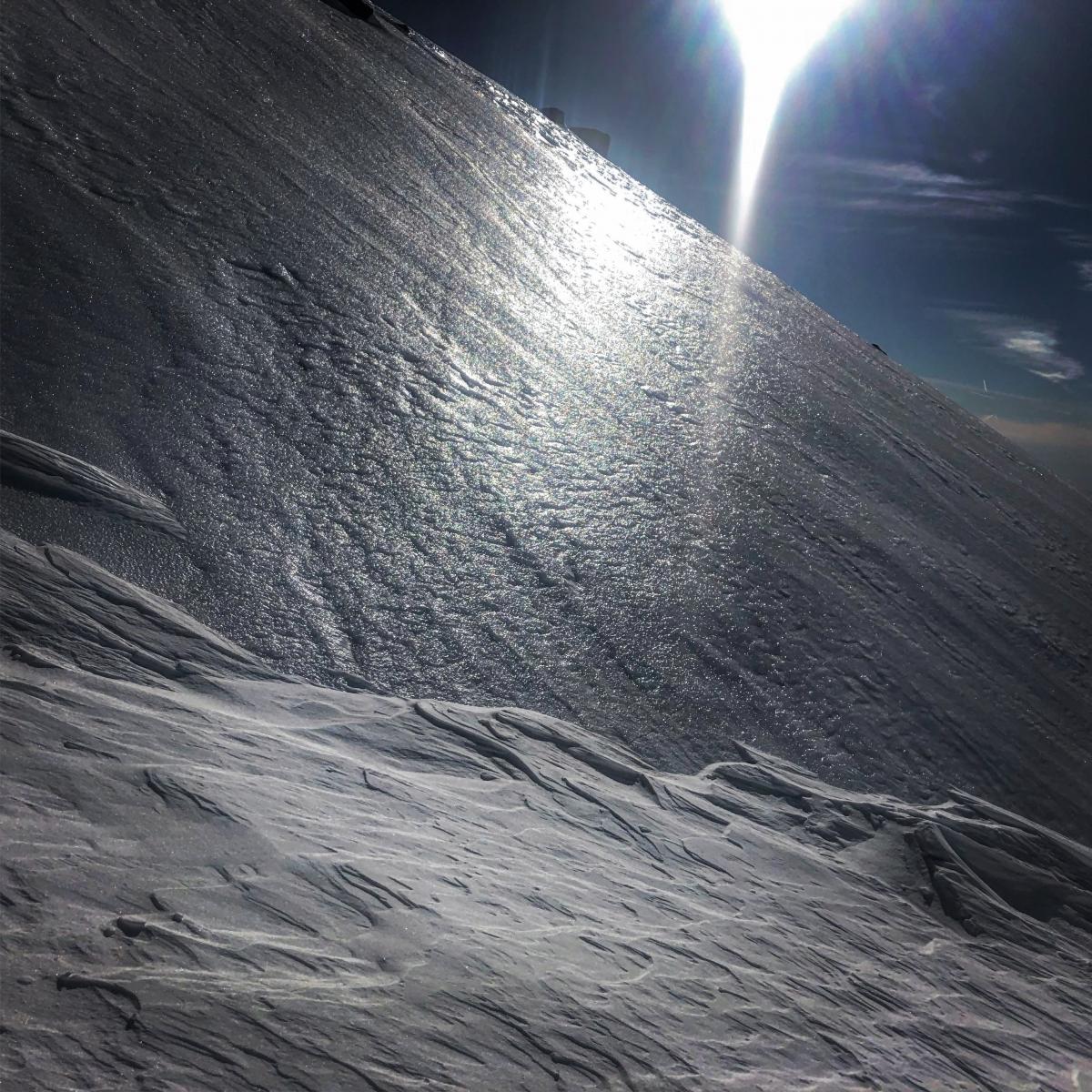
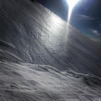
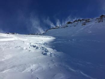
Have a look at that ice! This photo was taken yesterday in Avalanche Gulch by Ryan Sorenson. We can't stress enough to use extreme caution on these slopes, or better yet, stay off of them. Self-arrest would be near impossible.
Weather and Current Conditions
Weather Summary
High pressure continues to deflect precipitation to our north. Temperature inversions are present and fog is possible in the valleys once again. A front currently sliding over Vancounver Island will bring the chance of rain and snow tonight. For Mount Shasta, we may see a trace of snow with snow levels near 6,000 feet. Northerly wind is most notable with this weak system and we will see an increase in near and above treeline wind speeds this afternoon and evening. Longer term, uneventful weather will bring us through most of next week. Models are still in good agreement with a front moving onshore on Thursday.
24 Hour Weather Station Data @ 4:00 AM
| Weather Station | Temp (°F) | Wind (mi/hr) | Snow (in) | Comments | ||||||||
|---|---|---|---|---|---|---|---|---|---|---|---|---|
| Cur | Min | Max | Avg | Avg | Max Gust | Dir | Depth | New | Water Equivalent | Settlement | ||
| Mt. Shasta City (3540 ft) | 27 | 25 | 39 | 30.5 | 3 | N | ||||||
| Sand Flat (6750 ft) | 26 | 15 | 29 | 23 | 41 | 0 | 0 | 0 | ||||
| Ski Bowl (7600 ft) | 37 | 21 | 40 | 29 | 49 | 0 | 0 | 0 | ||||
| Gray Butte (8000 ft) | 34 | 24 | 34 | 27.5 | 7 | 37 | WSW | |||||
| Castle Lake (5870 ft) | station down | |||||||||||
| Mount Eddy (6509 ft) | 37.5 | 22.5 | 37.5 | 30.5 | 2 | 14 | SSE | 40 | 0 | 1 | ||
| Ash Creek Bowl (7250 ft) | station down | |||||||||||
| Ash Creek Ridge (7895 ft) | station down |
Two Day Mountain Weather Forecast
Produced in partnership with the Medford NWS
| For 7000 ft to 9000 ft | |||
|---|---|---|---|
|
Saturday (4 a.m. to 10 p.m.) |
Saturday Night (10 p.m. to 4 a.m.) |
Sunday (4 a.m. to 10 p.m.) |
|
| Weather | Mostly sunny | A 20% chance of snow after 10pm, partly cloudy, breezy. Snow level near 6,000 feet | Mostly sunny, breezy |
| Temperature (°F) | 41 | 35 | 35 |
| Wind (mi/hr) | North 5-10 | West 10-15 | Northwest 10-15 |
| Precipitation SWE / Snowfall (in) | / 0 | / trace | / 0 |
| For 9000 ft to 11000 ft | |||
| Saturday | Saturday Night | Sunday | |
| Weather | Mostly sunny, windy | A 20% chance of snow after 10pm. Partly cloudy, windy. | Mostly sunny, windy |
| Temperature (°F) | 29 | 24 | 27 |
| Wind (mi/hr) | Northwest 25-30 | West 0 | Northwest 45-50 |
| Precipitation SWE / Snowfall (in) | / 0 | / trace | / 0 |
Season Precipitation for Mount Shasta City
| Period | Measured (in) | Normal (in) | Percent of Normal (%) |
|---|---|---|---|
| From Oct 1, 2025 (the wet season) | 8.41 | 14.45 | 58 |
| Month to Date (since Jun 1, 2026) | 3.68 | 7.09 | 52 |
| Year to Date (since Jan 1, 2026) | 23.69 | 42.45 | 56 |

