

You are here
Avalanche Forecast for 2019-01-07 06:00
- EXPIRED ON January 8, 2019 @ 6:00 amPublished on January 7, 2019 @ 6:00 am
- Issued by Aaron Beverly - Mount Shasta Avalanche Center
Bottom Line
Avalanche danger remains elevated. Wind slabs likely exist above treeline and may continue to grow in size today. Though less likely, they could also exist near treeline. Storm slab avalanches were observed yesterday on steep wind protected slopes. This will remain a concern today near and below treeline. Today it'll be best to stick to slopes under 35 degrees and be wary of what terrain is above you.


Avalanche Problem 1: Wind Slab
-
Character ?

-
Aspect/Elevation ?
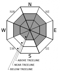
-
Likelihood ?CertainVery LikelyLikelyPossible
 Unlikely
 -
Size ?HistoricVery LargeLargeSmall

Effects of the wind near treeline on Gray Butte were minimal. No wind slabs were encountered. No above treeline observations were made, but if above treeline wind speeds verified yesterday, wind slabs are likely to exist on leeward aspects. There is plenty of new storm snow available for transport and a few more inches possible today and tonight. Strong westerly and southerly winds capable of transporting it are expected today.
These slabs may sit atop icy surfaces and crusts and could be reactive. Expect them primarily above treeline on west, east, and north facing aspects. But look for them everywhere. Visual clues that indicate winds slabs are nearby are fresh cornices, blowing snow, snow drifts, and uneven snow surfaces. Avoid wind loaded slopes over 35 degrees.
Avalanche Problem 2: Storm Slab
-
Character ?

-
Aspect/Elevation ?
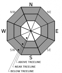
-
Likelihood ?CertainVery LikelyLikelyPossible
Unlikely
-
Size ?HistoricVery LargeLargeSmall
The storm slab problem will not linger for long, but since two storm slab avalanches were observed yesterday, we are keeping this problem on the list.
Storm Slabs form when new snow consolidates over a weaker layer or interface. They tend to have a short life span. They are easiest to trigger during periods of heavy snow and typically stabilize within a day or two after the storm cycle has ended.
Stay away from convex rollovers, unsupported slopes, and slopes over 40 degrees. This problem will be confined to protected areas below and near treeline.
Forecast Discussion
Avalanche danger remains elevated at all elevations, so if you venture out, keep in mind the 5 red flags indicating avalanche danger:
- Recent avalanche activity *
- Cracking, blocking, or whoomphing
- Significant snowfall in 24 hours *
- Strong winds **
- Rapid warming
* - this has happened
** - this has happened and will happen today.
Recent Observations
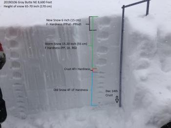
Total snow accumulation during storms on Saturday and Sunday was 25 inches. We have received 14 inches of snow in the last 24 hours at the Old Ski Bowl. Southerly and westerly winds have been light to moderate. Temperatures have ranged from 13 to 21 degrees F.
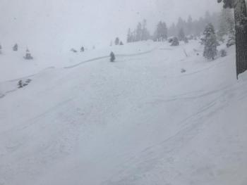
Natural and skier triggered storm slab avalanches were observed on a steep west/northwest aspect of Gray Butte. These failed on a crust at the old/new snow interface.
Very little wind effect was seen near treeline. No wind slabs, cornices, or pillows were encountered. Test profiles yielded a right side up snowpack with no notable column test failures.
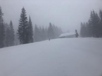
Low visibility prevented any observations above treeline.
Weather and Current Conditions
Weather Summary
We'll receive a short break in storm systems today. Scattered snow showers will linger with up to an inch of snow possible.
Above treeline, strong winds will blow from the west. Tonight winds will become southwest, with up to 4 inches of snow expected above 5500 feet.
A warm front moves in late tonight bringing copious amounts of water, strong to gale force winds, and high snow levels. Expect over 2 inches of precipitable water by early Wednesday morning. Snow levels will rise to 6800 feet tomorrow. Much of our snowpack will be lost below 5000 feet by Thursday.
Wet weather is expected to persist for the next 10 days.
24 Hour Weather Station Data @ 5:00 AM
| Weather Station | Temp (°F) | Wind (mi/hr) | Snow (in) | Comments | ||||||||
|---|---|---|---|---|---|---|---|---|---|---|---|---|
| Cur | Min | Max | Avg | Avg | Max Gust | Dir | Depth | New | Water Equivalent | Settlement | ||
| Mt. Shasta City (3540 ft) | 31 | 30 | 34 | 32 | 1 | N | ||||||
| Sand Flat (6750 ft) | 14 | 14 | 25 | 23 | 57 | 12 | 1 | 2 | ||||
| Ski Bowl (7600 ft) | 14 | 13 | 21 | 19 | 65.3 | 14 | 1.07 | 1.5 | ||||
| Gray Butte (8000 ft) | 14.5 | 14.5 | 20.5 | 18.5 | 16 | 37 | WNW | |||||
| Castle Lake (5870 ft) | station down | |||||||||||
| Mount Eddy (6509 ft) | 17.5 | 14 | 25 | 22 | 1 | 12 | SSW | 53.8 | 4 | 1 | ||
| Ash Creek Bowl (7250 ft) | station down | |||||||||||
| Ash Creek Ridge (7895 ft) | station down |
Two Day Mountain Weather Forecast
Produced in partnership with the Medford NWS
| For 7000 ft to 9000 ft | |||
|---|---|---|---|
|
Monday (4 a.m. to 10 p.m.) |
Monday Night (10 p.m. to 4 a.m.) |
Tuesday (4 a.m. to 10 p.m.) |
|
| Weather | Scattered snow showers. Mostly cloudy. Chance of precipitation is 40%. | Snow before 4 a.m., then rain and snow. Breezy. Chance of precipitation is 100%. | Rain and snow. The rain and snow could be heavy at times. Windy and gusty. Chance of precipitation is 100%. |
| Temperature (°F) | 32 | 34 | 36 |
| Wind (mi/hr) | South 10-15 | South 10-15 | South 20-25 |
| Precipitation SWE / Snowfall (in) | / < 1 | / 1-2 | / 1-4 |
| For 9000 ft to 11000 ft | |||
| Monday | Monday Night | Tuesday | |
| Weather | Scattered snow showers. Mostly cloudy. Very windy and gusty. Below zero wind chills. Chance of precipitation is 40%. | Snow. Very windy and gusty. Low wind chills. Chance of precipitation is 100%. | Snow. The snow could be heavy at times. Dangerous winds. Low wind chills. Chance of precipitation is 100%. |
| Temperature (°F) | 22 | 23 | 23 |
| Wind (mi/hr) | West 30-35 | Southwest 1 | South 55-65 |
| Precipitation SWE / Snowfall (in) | / 1 | / 2-4 | / 6-11 |
Season Precipitation for Mount Shasta City
| Period | Measured (in) | Normal (in) | Percent of Normal (%) |
|---|---|---|---|
| From Oct 1, 2025 (the wet season) | 10.00 | 16.62 | 60 |
| Month to Date (since Jun 1, 2026) | 1.59 | 1.41 | 113 |
| Year to Date (since Jan 1, 2026) | 1.59 | 1.41 | 113 |

