

You are here
Avalanche Forecast for 2019-01-12 05:56
- EXPIRED ON January 13, 2019 @ 5:56 amPublished on January 12, 2019 @ 5:56 am
- Issued by Nick Meyers - Shasta-Trinity National Forest
Bottom Line
The avalanche danger is LOW for all elevations and aspects. Use normal caution. Pay attention to locally gusty winds along ridgelines of higher terrain.


Avalanche Problem 1: Normal Caution
-
Character ?

-
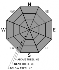
Aspect/Elevation ?
-
Likelihood ?CertainVery LikelyLikelyPossible
 Unlikely
 -
Size ?HistoricVery LargeLargeSmall

Always pay attention to the wind on Mount Shasta. Small, isolated wind slab avalanches are possible in leeward terrain if you see blowing snow. Locally gusty winds will continue today out of the south/southeast. Remember, low danger does not mean no danger. Use the ethos of normal caution to minimize consequences of the isolated avalanche event. Create a travel plan, stick to your travel plan, carry companion rescue gear, actively look for evidence of instability while on the snow, communicate well within your group, and expose only one person at a time to avalanche terrain.
Forecast Discussion
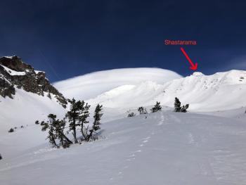
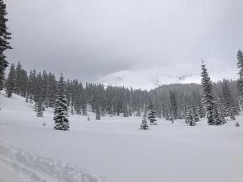
Bunny Flat will be busy today. The MSAC is hosting its annual snowmobile avalanche awareness workshop up in the Old Ski Bowl. Siskiyou County is also conducting an in house search and rescue training. Park respectfully, be patient and look for your wilderness experience on the mountain, not in the parking lot. Please remember that dogs are not allowed inside the Mount Shasta Wilderness or Sierra Club property boundaries. Have a splendid day!
Recent Observations
- Recent storm snow continues to gain strength. In isolated locations, some snowpit tests indicate that these layers retain the ability to propagate. Monitoring of these layers remains prudent up to the next new snow loading event.
- The previously unsupportable upper snowpack has become supportable in most areas.
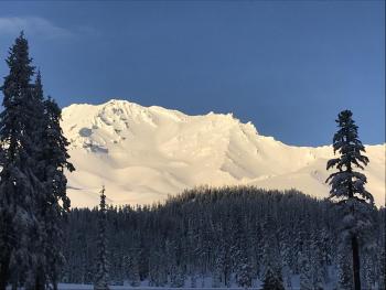
- Evidence of rain on snow and deep rain runnels below 6,500 feet
- Semi-supportable melt-freeze crust near and above treeline with pockets of smooth, dry powder.
- Wind affected snow near and above treeline from steady southeast wind over the past 24 hours, average speeds of 17 mi/hr with gusts to 30+ mi/hr.
- Blowing snow visible on ridges, locally gusty conditions
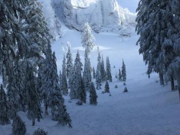
- Dry, chalky, hard wind textured snow above 9,000 feet.
- Ridgelines scoured with heavy rime and ice plastered to exposed rocks
- No recent avalanches
Weather and Current Conditions
Weather Summary
A few lingering showers are showing on the radar this morning for southern Siskiyou County, but the last of these showers is expected to end in the next few hours. A splitting system will leave our area today, one headed for southeast Alaska and the other to southern California. This will result in weather similar to yesterday, albeit the wind should be toned down a bit. High pressure will remain anchored near Idaho next week and exert an influence on our conditions, strengthening valley inversions during the night and mornings. Monday night clouds will be a sign of a gradual but significant shift in the weather. An offshore upper low is expected to track toward northern California and will usher in a period of active, wet, windy weather that will persist through at least Thursday night.
24 Hour Weather Station Data @ 4:00 AM
| Weather Station | Temp (°F) | Wind (mi/hr) | Snow (in) | Comments | ||||||||
|---|---|---|---|---|---|---|---|---|---|---|---|---|
| Cur | Min | Max | Avg | Avg | Max Gust | Dir | Depth | New | Water Equivalent | Settlement | ||
| Mt. Shasta City (3540 ft) | 31 | 31 | 48 | 39.5 | 1 | N | ||||||
| Sand Flat (6750 ft) | 30 | 29 | 32 | 30 | 69 | 0 | 0 | 2 | ||||
| Ski Bowl (7600 ft) | 31 | 25.5 | 34 | 30.5 | 81 | 0 | 0 | 3 | ||||
| Gray Butte (8000 ft) | 28 | 22 | 29 | 25.5 | 17 | 31 | SE | |||||
| Castle Lake (5870 ft) | station down | |||||||||||
| Mount Eddy (6509 ft) | 30 | 28.5 | 32 | 30.5 | 2 | 10 | SW | 58.5 | 0 | 1.5 | ||
| Ash Creek Bowl (7250 ft) | station down | |||||||||||
| Ash Creek Ridge (7895 ft) | station down |
Two Day Mountain Weather Forecast
Produced in partnership with the Medford NWS
| For 7000 ft to 9000 ft | |||
|---|---|---|---|
|
Saturday (4 a.m. to 10 p.m.) |
Saturday Night (10 p.m. to 4 a.m.) |
Sunday (4 a.m. to 10 p.m.) |
|
| Weather | A 30% chance of snow showers before 10AM, then becoming mostly sunny. | Mostly clear | Sunny |
| Temperature (°F) | 36 | 26 | 34 |
| Wind (mi/hr) | South 5-10 | Southeast 5-10 | East 5-10 |
| Precipitation SWE / Snowfall (in) | / < .5 | / 0 | / 0 |
| For 9000 ft to 11000 ft | |||
| Saturday | Saturday Night | Sunday | |
| Weather | A 30% chance of snow showers before 10AM, becoming mostly sunny and breezy. | Mostly clear | Sunny |
| Temperature (°F) | 24 | 24 | 27 |
| Wind (mi/hr) | Southeast 20-25 | Southeast , .5 | Southeast 10-15 |
| Precipitation SWE / Snowfall (in) | / , .5 | / 0 | / 0 |
Season Precipitation for Mount Shasta City
| Period | Measured (in) | Normal (in) | Percent of Normal (%) |
|---|---|---|---|
| From Oct 1, 2025 (the wet season) | 13.42 | 17.85 | 75 |
| Month to Date (since Jun 1, 2026) | 5.01 | 2.64 | 190 |
| Year to Date (since Jan 1, 2026) | 5.01 | 2.64 | 190 |

