

You are here
Avalanche Forecast for 2019-01-13 06:00
- EXPIRED ON January 14, 2019 @ 6:00 amPublished on January 13, 2019 @ 6:00 am
- Issued by Aaron Beverly - Mount Shasta Avalanche Center
Bottom Line
The avalanche danger is LOW for all elevations and aspects. Exercise normal caution. Snow returns to the region on Tuesday with significant snowfall expected Wednesday and Thursday.


Avalanche Problem 1: Normal Caution
-
Character ?

-
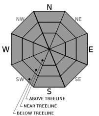
Aspect/Elevation ?
-
Likelihood ?CertainVery LikelyLikelyPossible
 Unlikely
Avalanche danger is LOW. Exercise normal caution. This means:
- Continue to watch for isolated wind slabs.
- Carry a beacon, shovel, and probe and know how to use them.
- Create a travel plan and stick to it.
- Look for evidence of instability.
- Expose only one person at a time in avalanche terrain.
Recent Observations
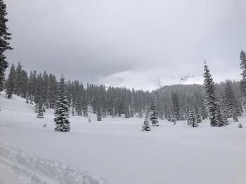
Total height of snow at the Old Ski Bowl is 80 inches. In the last 24 hours, no new snow has been received, east/southeast winds have ranged from 7 to 28 mi/hr, averaging 15, and gusting up to 37.
Near and above treeline snow surfaces are chalky and wind textured or settled and dry. Below treeline, a melt-freeze crust exists.
Some snow is available for transport and continues to be blown above treeline, though no wind slab development has been observed. No avalanches or other signs of instability have been seen. Snowpack has shown no reactivity to the numerous skiers and snowmobilers using it.
Mount Shasta is 173% of normal for precipitation in January!
Weather and Current Conditions
Weather Summary
Conditions will remain mostly clear and dry until tomorrow night. A brief spike in temperature is expected today, but otherwise temperatures should remain near or below freezing above 5000 feet. Above treeline expect moderate southeast winds.
A low pressure system will begin to affect the area tomorrow night bringing minimal precipitation Tuesday. A second system follows late Tuesday night that should drop over 2 inches of water Wednesday and Thursday. Snow levels should be near or below 5000 feet for both of these weather events.
24 Hour Weather Station Data @ 4:00 AM
| Weather Station | Temp (°F) | Wind (mi/hr) | Snow (in) | Comments | ||||||||
|---|---|---|---|---|---|---|---|---|---|---|---|---|
| Cur | Min | Max | Avg | Avg | Max Gust | Dir | Depth | New | Water Equivalent | Settlement | ||
| Mt. Shasta City (3540 ft) | 32 | 30 | 52 | 40.5 | 1 | N | ||||||
| Sand Flat (6750 ft) | 30 | 29 | 34 | 32 | 67 | 0 | 0 | 2 | ||||
| Ski Bowl (7600 ft) | 30 | 29 | 35.5 | 32 | 79.7 | 0 | 0 | 1.5 | ||||
| Gray Butte (8000 ft) | 26.5 | 26.5 | 33 | 29 | 15 | 37 | ESE | |||||
| Castle Lake (5870 ft) | station down | |||||||||||
| Mount Eddy (6509 ft) | 27.5 | 27.5 | 35 | 31 | 2 | 8 | SW | 57.7 | 0 | 1 | ||
| Ash Creek Bowl (7250 ft) | station down | |||||||||||
| Ash Creek Ridge (7895 ft) | station down |
Two Day Mountain Weather Forecast
Produced in partnership with the Medford NWS
| For 7000 ft to 9000 ft | |||
|---|---|---|---|
|
Sunday (4 a.m. to 10 p.m.) |
Sunday Night (10 p.m. to 4 a.m.) |
Monday (4 a.m. to 10 p.m.) |
|
| Weather | Sunny. | Mostly clear. | Mostly sunny. A 10 percent chance of snow after 4 p.m. |
| Temperature (°F) | 37 | 23 | 33 |
| Wind (mi/hr) | East 10-15 | East 5-10 | East 5-10 |
| Precipitation SWE / Snowfall (in) | / 0 | / 0 | / 0 |
| For 9000 ft to 11000 ft | |||
| Sunday | Sunday Night | Monday | |
| Weather | Sunny. Windy. | Mostly clear. Windy. | Mostly sunny. Windy. A 10 percent chance of snow after 4 p.m. |
| Temperature (°F) | 28 | 21 | 21 |
| Wind (mi/hr) | Southeast 20-25 | Southeast 0 | Southeast 20-25 |
| Precipitation SWE / Snowfall (in) | / 0 | / 0 | / 0 |
Season Precipitation for Mount Shasta City
| Period | Measured (in) | Normal (in) | Percent of Normal (%) |
|---|---|---|---|
| From Oct 1, 2025 (the wet season) | 13.42 | 18.10 | 74 |
| Month to Date (since Jun 1, 2026) | 5.01 | 2.89 | 173 |
| Year to Date (since Jan 1, 2026) | 5.01 | 2.89 | 173 |

