

You are here
Avalanche Forecast for 2019-01-14 06:30
- EXPIRED ON January 15, 2019 @ 6:30 amPublished on January 14, 2019 @ 6:30 am
- Issued by Aaron Beverly - Mount Shasta Avalanche Center
Bottom Line
The avalanche danger is LOW for all elevations and aspects. Exercise normal caution. Continue to watch for isolated wind slabs. A low pressure system begins to impact the area tomorrow bringing significant snow to elevations above 4,000 feet.


Avalanche Problem 1: Normal Caution
-
Character ?

-
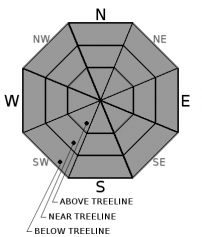
Aspect/Elevation ?
-
Likelihood ?CertainVery LikelyLikelyPossible
 Unlikely
Avalanche danger is LOW. Exercise normal caution. This means:
- East winds pummeled the upper mountain yesterday. Continue to watch for isolated wind slabs.
- Carry a beacon, shovel, and probe and know how to use them.
- Create a travel plan and stick to it.
- Look for evidence of instability.
- Expose only one person at a time in avalanche terrain.
LOW avalanche danger means natural and human-triggered avalanches are unlikely but not impossible. Be wary of small avalanches in isolated areas or extreme terrain.
Forecast Discussion
Strong winds and a spike in temperatures yesterday have probably further destroyed snow surface conditions for riders and sliders. The good news for powder hounds is significant snow is on the way this week for elevations above 4,000 feet. Monitor the forecast in the coming days as avalanche danger will increase when tonight's incoming storm begins to impact the area.
Recent Observations
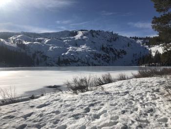
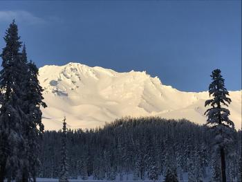
Total height of snow at the Old Ski Bowl is 78 inches. Winds were strong and gusty yesterday afternoon and last night. Speeds ranged from 20 to 37 mi/hr, averaged 25, and gusted up to 49. Near treeline temperatures ranged from 26 to 39 degrees.
Above treeline snow surfaces are chalky and wind textured with pockets of settled dry snow. These conditions transition to a melt-freeze crust below treeline.
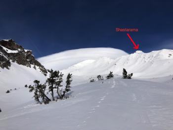
Similar conditions exist around Mount Eddy. An old wind slab avalanche was observed on a west/northwest aspect that likely occurred during or right after the storm ending last Thursday.
No new avalanches or other signs of instability have been seen for several days. The snowpack has shown no reactivity to the numerous skiers and snowmobilers actively using it.
Weather and Current Conditions
Weather Summary
Today above 5,000 feet, expect light to moderate east and southeast winds and temperatures near or below freezing.
Sunny weather will give way to increasing clouds this afternoon as a large low pressure system off the coast begins to impact the area. This impact will begin to be felt tomorrow morning as moisture is swung into the area from the south. Though QPF data shows only 0.16 inches of precipitable water tomorrow, southerly flows may enhance precipitation on Mount Shasta bringing 3-9 inches above 3,500 feet. The storm will intensify Tuesday night. By Thursday, the Mount Shasta area should see over 3 inches of water and up to two feet of snow. Snow levels look to stay near or below 4,000 feet throughout.
24 Hour Weather Station Data @ 4:00 AM
| Weather Station | Temp (°F) | Wind (mi/hr) | Snow (in) | Comments | ||||||||
|---|---|---|---|---|---|---|---|---|---|---|---|---|
| Cur | Min | Max | Avg | Avg | Max Gust | Dir | Depth | New | Water Equivalent | Settlement | ||
| Mt. Shasta City (3540 ft) | 34 | 29 | 52 | 39.5 | 2 | N | ||||||
| Sand Flat (6750 ft) | 27 | 25 | 37 | 31 | 66 | 0 | 0 | 5 | ||||
| Ski Bowl (7600 ft) | 25.5 | 25.5 | 38.5 | 32.5 | 77.9 | 0 | 0 | 2 | ||||
| Gray Butte (8000 ft) | 22.5 | 22.5 | 33.5 | 29.5 | 24 | 49 | E | |||||
| Castle Lake (5870 ft) | station down | |||||||||||
| Mount Eddy (6509 ft) | 22.5 | 22.5 | 35 | 28.5 | 2 | 7 | WSW | 56.4 | 0 | 1 | ||
| Ash Creek Bowl (7250 ft) | station down | |||||||||||
| Ash Creek Ridge (7895 ft) | station down |
Two Day Mountain Weather Forecast
Produced in partnership with the Medford NWS
| For 7000 ft to 9000 ft | |||
|---|---|---|---|
|
Monday (4 a.m. to 10 p.m.) |
Monday Night (10 p.m. to 4 a.m.) |
Tuesday (4 a.m. to 10 p.m.) |
|
| Weather | Mostly sunny. | A slight chance of snow showers before 10 p.m., then a chance of snow after 10 p.m. Mostly cloudy. Chance of precipitation is 30%. | Snow. High near 31. Breezy and gusty. Chance of precipitation is 90%. |
| Temperature (°F) | 31 | 25 | 31 |
| Wind (mi/hr) | East 10-15 | Southeast 10-15 | South 20-25 |
| Precipitation SWE / Snowfall (in) | / 0 | / < 1 | / 3-6 |
| For 9000 ft to 11000 ft | |||
| Monday | Monday Night | Tuesday | |
| Weather | Mostly sunny. Windy and gusty. Low wind chills. | Mostly cloudy. A slight chance of snow showers before 10 p.m., then snow likely.Windy and gusty. Low wind chills. Chance of precipitation is 60%. | Snow. Windy and gusty. Low wind chills. Chance of precipitation is 90%. |
| Temperature (°F) | 20 | 16 | 30 |
| Wind (mi/hr) | Southeast 20-25 | South 0 | South 20-25 |
| Precipitation SWE / Snowfall (in) | / 0 | / < 1 | / 3-9 |
Season Precipitation for Mount Shasta City
| Period | Measured (in) | Normal (in) | Percent of Normal (%) |
|---|---|---|---|
| From Oct 1, 2025 (the wet season) | 13.42 | 18.34 | 73 |
| Month to Date (since Jun 1, 2026) | 5.01 | 3.13 | 160 |
| Year to Date (since Jan 1, 2026) | 5.01 | 3.13 | 160 |

