

You are here
Avalanche Forecast for 2019-01-20 06:05
- EXPIRED ON January 21, 2019 @ 6:05 amPublished on January 20, 2019 @ 6:05 am
- Issued by Ryan Sorenson - Mount Shasta Avalanche Center
Bottom Line
Considerable avalanche danger remains above treeline due to wind slab and cornice avalanche problems. Recent rain observed up to 8,000 feet decreased avalanche likelihood below and near treeline. Destructive avalanches remain possible today above treeline. New snow and wind will increase wind slab and cornice problems.


Avalanche Problem 1: Wind Slab
-
Character ?

-
Aspect/Elevation ?
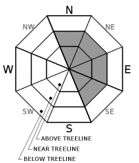
-
Likelihood ?CertainVery LikelyLikelyPossible
 Unlikely
 -
Size ?HistoricVery LargeLargeSmall

This storm brought wind speeds ideal for wind loading. Wind slabs exist in near and above treeline terrain, along with cornices. Recent rain has decreased the likelihood for triggering wind slabs however, hazard remains today as 3-6 inches of new snow falls.
Frozen, previously saturated snow may create the ideal bed surface for new wind slabs to form. Moderate to strong south wind is predicted near and above treeline today.
Wind has blown moderately out of the northwest to southeast over the past 3 days. Southwest wind was felt yesterday. Gray Butte recorded an average wind speed of 14 mi/hr over the last 24 hours.
Moderate to strong southwesterlies will be felt today in exposed terrain and further wind loading will occur. Potentially large and destructive avalanches are unlikely but remain possible above treeline. Remember wind can deposit snow 10 times more rapidly than snow falling from the sky.
Avalanche Problem 2: Cornice
-
Character ?

-
Aspect/Elevation ?
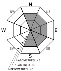
-
Likelihood ?CertainVery LikelyLikelyPossible
Unlikely
-
Size ?HistoricVery LargeLargeSmall
Cornices exist along ridgelines and can be human triggered. Identify terra firm by looking for trees, rock(s) or other features that signify stable ground. Large cornices can sometime break back much further than expected. Give them a wide berth.
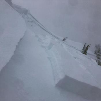
Overhanging cornices have been observed in the forecast area during this storm. These likely broke during the rain event yesterday. Hazard still exist as new snow and wind continue to add weight to what remains.
Low visibility limited observations of cornice activity yesterday.
Forecast Discussion
Rain made for some wet and wild conditions for the Shasta Ascension backcountry ski race yesterday. This rain teased out problem layers and increased stability of the 3-foot snowpack below. Avalanche hazard remains elevated as another 3-6 inches of snow predicted in the next 24 hours will add additional weight. Above treeline observations and data are lacking due to very poor visibility.
Carry rescue gear, know how to use it, ski and ride one at a time in avalanche terrain, don't regroup in runout zones.
Recent Observations
- Rain was observed up to 8,000 feet on Gray Butte yesterday.
- Heavy, new snow in the last 24 hours was 1-2 inches.
- Winds have been light to moderate, averaging 14 mph with average gusts near 37 mph, primarily blowing out of the southwest.
- Cornices have previously formed on leeward NE-E-SE ridgelines.
- Treeline: Ski penetration: 1-3 inches / Boot penetration: 2-3 feet
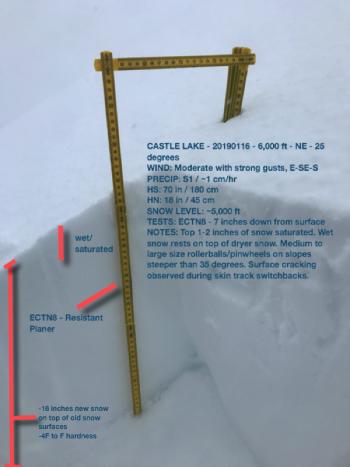
- Snowpit tests show strong force required to activate a weak layer approximately 12 inches deep within the snowpack, just below a prominent 1F, cohesive layer that is about 4 inches thick.
- ECTN22@12"-rp, north facing, 25 degrees, 8,000 feet
Weather and Current Conditions
Weather Summary
The current storm will continue to impact the forecast area until Monday. A high-pressure ridge will begin to build as the storm slowly moves out. Today will be a transition day as the storm moves east. Snow levels will drop to 4,500 feet as the predicted .80 inches of precipitable water falls. New snow totals are forecasted for 3-6 inches in the next 24 hours. Snow levels could drop as low as 3,700 feet through the night.
South wind will be moderate to strong below and near treeline. Strong, gusty southwest wind will impact the alpine today. Temperatures are dropping to the low 30s today. We should see a low in the mid 20s tonight. Clear skies and cold temperatures are expected Monday.
24 Hour Weather Station Data @ 4:00 AM
| Weather Station | Temp (°F) | Wind (mi/hr) | Snow (in) | Comments | ||||||||
|---|---|---|---|---|---|---|---|---|---|---|---|---|
| Cur | Min | Max | Avg | Avg | Max Gust | Dir | Depth | New | Water Equivalent | Settlement | ||
| Mt. Shasta City (3540 ft) | ||||||||||||
| Sand Flat (6750 ft) | 34 | 32 | 34 | 33 | 90 | 2 | 1 | 5 | ||||
| Ski Bowl (7600 ft) | 31.5 | 28.5 | 32 | 31.5 | 110 | 1 | 1.8 | 4.5 | ||||
| Gray Butte (8000 ft) | 32 | 28 | 32 | 31 | 14 | 37 | WSW | |||||
| Castle Lake (5870 ft) | ||||||||||||
| Mount Eddy (6509 ft) | 32.5 | 32 | 36 | 34 | 2 | 16 | SSE | 81 | 1 | 4 | ||
| Ash Creek Bowl (7250 ft) | ||||||||||||
| Ash Creek Ridge (7895 ft) |
Two Day Mountain Weather Forecast
Produced in partnership with the Medford NWS
| For 7000 ft to 9000 ft | |||
|---|---|---|---|
|
Sunday (4 a.m. to 10 p.m.) |
Sunday Night (10 p.m. to 4 a.m.) |
Monday (4 a.m. to 10 p.m.) |
|
| Weather | Rain and snow. Snow level near 4,200 feet. Chance of snow 100% | Snow showers. Snow level near 3,700 feet. Chance of snow 80%. | Snow showers possible. Chance of snow 40%. |
| Temperature (°F) | 32 | 22 | 30 |
| Wind (mi/hr) | South 10-15 | Northwest 5-10 | Northwest 10-15 |
| Precipitation SWE / Snowfall (in) | / 3-6 | / 1-3 | / 1 |
| For 9000 ft to 11000 ft | |||
| Sunday | Sunday Night | Monday | |
| Weather | Snow, windy. Chance of precipitation 90% | Snow showers. Chance of precipitation 80% | Snow showers possible. Chance of snow 40%. |
| Temperature (°F) | 27 and falling | 17 | 17 |
| Wind (mi/hr) | Southwest 30-40 | Northwest 3-6 | Northwest 25-35 |
| Precipitation SWE / Snowfall (in) | / 3-6 | / 1-3 | / 1 |
Season Precipitation for Mount Shasta City
| Period | Measured (in) | Normal (in) | Percent of Normal (%) |
|---|---|---|---|
| From Oct 1, 2025 (the wet season) | 13.93 | 19.69 | 71 |
| Month to Date (since Jun 1, 2026) | 5.52 | 4.48 | 123 |
| Year to Date (since Jan 1, 2026) | 5.52 | 4.48 | 123 |

