

You are here
Avalanche Forecast for 2019-01-21 06:00
- EXPIRED ON January 22, 2019 @ 6:00 amPublished on January 21, 2019 @ 6:00 am
- Issued by Ryan Sorenson - Mount Shasta Avalanche Center
Bottom Line
The several feet of new snow over the past week has settled out due to rainy conditions on Saturday. Large natural and human triggered avalanches are unlikely. Cornice features remain along ridgelines and could be human triggered. Fresh wind slabs remain a concern near and above treeline. These are likely to remain small, but could grow in size as light to moderate northerly wind and snow showers continue to impact the forecast area today.


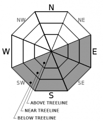
Avalanche Problem 1: Wind Slab
-
Character ?

-
Aspect/Elevation ?
-
Likelihood ?CertainVery LikelyLikelyPossible
 Unlikely
 -
Size ?HistoricVery LargeLargeSmall

We have received 1-3 inches of new snow in the last 24 hours. This new snow sits on top of a mostly supportable rain crust from Saturday. This snow is ripe for transport as the storm moves out of the forecast area this afternoon. Light to moderate northerly wind is predicted today.
Rember, even when snow is not falling from the sky, avalanches are possible. Wind can deposit snow 10 times faster than it can fall from the sky. Look for wind slabs on the lee side of ridges in terrain steeper than 35 degrees. Wind slabs are often smooth and round and sometimes sound hollow.
Exercise caution near slopes greater than 35 degrees and look for signs of wind slab problems:
Blowing snow
Cornices
Wind pillows
Shooting cracks
Hollow sounding snow
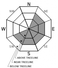
Avalanche Problem 2: Cornice
-
Character ?

-
Aspect/Elevation ?
-
Likelihood ?CertainVery LikelyLikelyPossible
Unlikely
-
Size ?HistoricVery LargeLargeSmall
Cornices exist along ridgelines and can be human triggered. Identify terra firm by looking for trees, rock(s) or other features that signify stable ground. Large cornices can sometime break back much further than expected. Give them a wide berth.
Cornices will continue to settle and strengthen throughout the week.
Forecast Discussion
Continue to use caution out there, especially on steeper slopes and/or extreme terrain. Have a great day!
Recent Observations
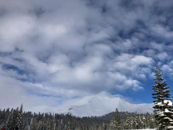
Light snow showers and cloudy conditions were observed yesterday. A brief clearing in the afternoon gave a glimpse of the conditions on the mountain.
Current snow condition:
- Two to three feet of consolidated snow rests on top of old snow surfaces.
- Rain runneled snow exists below 8,000 feet.
- 1-3 inches of new soft snow over rain crust.
- Snow surface texture was variable with an icy, rain crust in exposed areas with filled in pockets of softer, newly deposited snow.
- An icy and sometimes breakable crust will be found on wind exposed ridgelines.
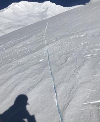
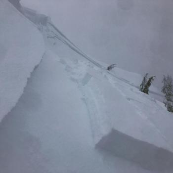
- Many cornice failures have occurred on ridgelines.
-
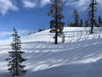
Settlement cones noted around pine trees.
Weather and Current Conditions
Weather Summary
There is a chance of snow showers this morning as the storm moves out to our northeast. Cloudy conditions will likely clear this afternoon. Snow accumulation of around 1 inch is possible this morning, as most of the precipitation will remain to our north. Temperatures should remain in the low to mid-20s today. Clear skies and cold temperatures with low wind chill values are expected tomorrow.
Wind will stay light to moderate out of the northwest today. Showers will decrease this morning as a ridge of high pressure settles in for the rest of the week. Mostly sunny conditions are expected through this weekend. No sign of new incoming storms at this point.
24 Hour Weather Station Data @ 2:00 AM
| Weather Station | Temp (°F) | Wind (mi/hr) | Snow (in) | Comments | ||||||||
|---|---|---|---|---|---|---|---|---|---|---|---|---|
| Cur | Min | Max | Avg | Avg | Max Gust | Dir | Depth | New | Water Equivalent | Settlement | ||
| Mt. Shasta City (3540 ft) | 37 | 35.5 | 46 | 39.5 | 1 | N | ||||||
| Sand Flat (6750 ft) | 23 | 23 | 34 | 29 | 90 | 1 | 1 | 3 | ||||
| Ski Bowl (7600 ft) | 18.5 | 18.5 | 31.5 | 25 | 109 | 2.6 | 0.69 | 3.2 | ||||
| Gray Butte (8000 ft) | 20.5 | 20.5 | 32 | 25.5 | 14 | 49 | WNW | |||||
| Castle Lake (5870 ft) | station down | |||||||||||
| Mount Eddy (6509 ft) | 22 | 22 | 32.5 | 27.5 | 0 | 9 | 80 | 0 | 1 | |||
| Ash Creek Bowl (7250 ft) | station down | |||||||||||
| Ash Creek Ridge (7895 ft) | station down |
Two Day Mountain Weather Forecast
Produced in partnership with the Medford NWS
| For 7000 ft to 9000 ft | |||
|---|---|---|---|
|
Monday (4 a.m. to 10 p.m.) |
Monday Night (10 p.m. to 4 a.m.) |
Tuesday (4 a.m. to 10 p.m.) |
|
| Weather | Cloudy this morning, then clearing. A %50 chance of snow showers before 11 am | Mostly clear, cool temperatures in the low 20s | Partly cloudy, highs in the mid 30s |
| Temperature (°F) | 29 | 20 | 35 |
| Wind (mi/hr) | Northwest 5-10 | North 5-10 | North 0-5 |
| Precipitation SWE / Snowfall (in) | / 0 - .5 | / 0 | / 0 |
| For 9000 ft to 11000 ft | |||
| Monday | Monday Night | Tuesday | |
| Weather | Cloudy this morning, then clearing. A %50 chance of snow showers before 11 am | Mostly clear, cold temperatures in the single digits. Below zero wind chill | Partly cloudy, highs in the high 20s |
| Temperature (°F) | 10 | 2 | 25 |
| Wind (mi/hr) | North 10-15 | North 0 - .5 | North 10-15 |
| Precipitation SWE / Snowfall (in) | / 0 - .5 | / 0 | / 0 |
Season Precipitation for Mount Shasta City
| Period | Measured (in) | Normal (in) | Percent of Normal (%) |
|---|---|---|---|
| From Oct 1, 2025 (the wet season) | 13.93 | 19.91 | 70 |
| Month to Date (since Jun 1, 2026) | 5.52 | 4.70 | 117 |
| Year to Date (since Jan 1, 2026) | 5.52 | 4.70 | 117 |

