

You are here
Avalanche Forecast for 2019-02-12 06:30
- EXPIRED ON February 13, 2019 @ 6:30 amPublished on February 12, 2019 @ 6:30 am
- Issued by Aaron Beverly - Mount Shasta Avalanche Center
Bottom Line
Significant snowfall and wind is expected after 4 p.m. Avalanche danger will rise from moderate to considerable by tomorrow morning. Wind slabs are the primary concern, but breaking cornices and storm slabs are secondary issues. Two to three feet of snow will fall by Thursday afternoon. Dangerous avalanche conditions will exist and conservative decision making will be essential.


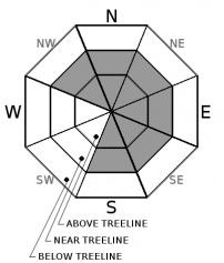
Avalanche Problem 1: Wind Slab
-
Character ?

-
Aspect/Elevation ?

-
Likelihood ?CertainVery LikelyLikelyPossible
 Unlikely
 -
Size ?HistoricVery LargeLargeSmall

Old and new wind slabs will be of concern today. New wind slabs will begin forming after 4 p.m. Stay away from wind loaded aspects greater than 35 degrees.
Propagating cracks, whumphing sounds, cornices, and smooth wind pillows are some indicators that a wind slab problem exists nearby.
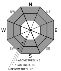
Avalanche Problem 2: Cornice
-
Character ?

-
Aspect/Elevation ?
-
Likelihood ?CertainVery LikelyLikelyPossible
Unlikely
-
Size ?HistoricVery LargeLargeSmall
When wind slabs are a problem, cornices are usually lurking above. They were reactive to ski trigger on Sunday. They may continue to grow late tonight. They can break far back from overhangs. Stay well clear when traveling along ridgetops.
Avalanche Problem 3: Storm Slab
-
Character ?

-
Aspect/Elevation ?
-
Likelihood ?CertainVery LikelyLikelyPossible
Unlikely
-
Size ?HistoricVery LargeLargeSmall
Don't expect to see these unless you are out and about late tonight. With over a foot of snow expected to fall between 4 p.m. and 4 a.m., these will become an issue on slopes approaching 40 degrees.
A storm slab avalanche is a release of a soft cohesive layer of new snow that breaks within the storm snow or on the old snow surface. Storm slab problems typically last between a few hours and few days during and after new snow fall. They can occur on all aspects protected from the wind.
Forecast Discussion
The lack of observations near and above treeline make it difficult to gauge avalanche danger today. Snow settlement and freezing drizzle have likely reduced avalanche danger to moderate levels, but the significant snow and winds expected after 4 p.m. will cause the danger to rise back to considerable by tomorrow.
Between tonight and Thursday afternoon, 2-3 feet of snow is expected. Rising snow levels will create an upside down snowpack configuration. This coupled with the significant weight and new wind slabs sitting atop a breakable ice layer sitting atop light snow and old firm wind slabs will undoubtedly create a variety of avalanche hazards. Be conservative and evaluate the snowpack carefully if venturing out in the next few days.
Recent Observations
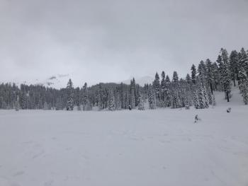
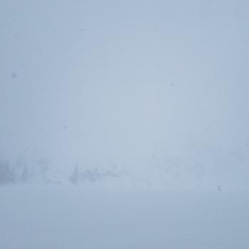
Low visibility and whiteout conditions limited any useful observations near and above treeline yesterday. No signs of instability were seen below treeline.
Freezing drizzle was reported by skiers throughout the forecast area blanketing the low density snow surface with a thin breakable layer of ice.
Westerly aspects and open areas above treeline have become wind affected and scoured.
Sunday, a large natural wind slab avalanche was reported on Ash Creek Butte and plenty of propagating cracks and blocking were seen on Gray Butte. Small wind slabs and cornices were reactive to ski trigger.
For the last 24 hours, the Old Ski Bowl weather station reports about 1.5 inches of settlement. Temperatures ranged from 11 to 17 degrees and westerly winds were light to moderate.

Weather and Current Conditions
Weather Summary
A couple of low pressure systems will impact the area over the next few days bringing up to 4.3 inches of precipitable water, with the bulk of this coming tonight through Thursday. Snow levels will start low but could rise to 6,000 feet late in the day Wednesday.
Over the next 24 hours expect 11 - 19 inches of snow above 2500 feet, 2-4 today, and 9-15 after 4 p.m. Southerly winds will be moderate to gale force.
24 Hour Weather Station Data @ 5:00 AM
| Weather Station | Temp (°F) | Wind (mi/hr) | Snow (in) | Comments | ||||||||
|---|---|---|---|---|---|---|---|---|---|---|---|---|
| Cur | Min | Max | Avg | Avg | Max Gust | Dir | Depth | New | Water Equivalent | Settlement | ||
| Mt. Shasta City (3540 ft) | 31 | 27 | 32 | 30.5 | 4 | ESE | ||||||
| Sand Flat (6750 ft) | 20 | 16 | 22 | 20 | 90 | 0 | 0 | 0.5 | ||||
| Ski Bowl (7600 ft) | 16.5 | 11.5 | 18 | 15.5 | 113.1 | 0 | 0.06 | 1.5 | ||||
| Gray Butte (8000 ft) | 15.5 | 10.5 | 17.5 | 15 | 13 | 31 | WNW | |||||
| Castle Lake (5870 ft) | 21.5 | 18 | 23 | 21.5 | 75.2 | 1 | 0 | |||||
| Mount Eddy (6509 ft) | 20 | 14 | 20 | 16 | 1 | 6 | SSW | 83 | 0 | 0.5 | ||
| Ash Creek Bowl (7250 ft) | station down | |||||||||||
| Ash Creek Ridge (7895 ft) | station down |
Two Day Mountain Weather Forecast
Produced in partnership with the Medford NWS
| For 7000 ft to 9000 ft | |||
|---|---|---|---|
|
Tuesday (4 a.m. to 10 p.m.) |
Tuesday Night (10 p.m. to 4 a.m.) |
Wednesday (4 a.m. to 10 p.m.) |
|
| Weather | Snow. Windy. Chance of precipitation is 100%. | Snow. The snow could be heavy at times. Blustery. Chance of precipitation is 100%. | Snow. The snow could be heavy at times. Blustery. Chance of precipitation is 100%. |
| Temperature (°F) | 24 | 21 | 30 |
| Wind (mi/hr) | South 20-25 | South 15-20 | South 20-25 |
| Precipitation SWE / Snowfall (in) | / 2-4 | / 9-15 | / 5-12 |
| For 9000 ft to 11000 ft | |||
| Tuesday | Tuesday Night | Wednesday | |
| Weather | Snow. Wind chill values as low as -9. Very windy and gusty. Chance of precipitation is 100%. | Snow. The snow could be heavy at times. Wind chill values as low as -8. Very windy and gusty. Chance of precipitation is 100%. | Snow. The snow could be heavy at times. Wind chill values as low as 6. Very windy and gusty. Chance of precipitation is 100%. |
| Temperature (°F) | 12 | 11 | 13 |
| Wind (mi/hr) | Southwest 45-55 | Southwest 2-4 | Southwest 35-45 |
| Precipitation SWE / Snowfall (in) | / 2-4 | / 9-15` | / 5-12 |
Season Precipitation for Mount Shasta City
| Period | Measured (in) | Normal (in) | Percent of Normal (%) |
|---|---|---|---|
| From Oct 1, 2025 (the wet season) | 16.60 | 24.93 | 67 |
| Month to Date (since Jun 1, 2026) | 2.67 | 2.66 | 100 |
| Year to Date (since Jan 1, 2026) | 8.19 | 9.72 | 84 |

