

You are here
Avalanche Forecast for 2019-02-13 05:04
- EXPIRED ON February 14, 2019 @ 5:04 amPublished on February 13, 2019 @ 5:04 am
- Issued by Ryan Sorenson - Mount Shasta Avalanche Center
Bottom Line
A major winter storm is impacting the forecast area today. Strong wind and new snow have increased the avalanche danger to HIGH. Wind slabs, storm slabs, and cornice failures are all a concern. Travel in avalanche terrain is not recommended. Natural and human triggered wind slabs are likely. Avalanche size will continue to increase as more snow falls today with a chance for freezing rain.


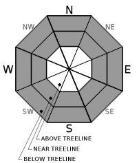
Avalanche Problem 1: Wind Slab
-
Character ?

-
Aspect/Elevation ?
-
Likelihood ?CertainVery LikelyLikelyPossible
 Unlikely
 -
Size ?HistoricVery LargeLargeSmall

Old and new wind slabs will be of concern today. New wind slabs are likely to grow several feet thick. Stay away from wind loaded slopes. Human and natural wind slabs are likely.
Propagating cracks, whumphing sounds, cornices, and smooth wind pillows are some indicators that a wind slab problem exists nearby.
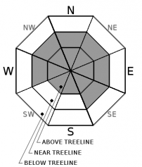
Avalanche Problem 2: Storm Slab
-
Character ?

-
Aspect/Elevation ?
-
Likelihood ?CertainVery LikelyLikelyPossible
Unlikely
-
Size ?HistoricVery LargeLargeSmall
Nearly 20 inches of snow fell in the last 24 hours. It will continue to snow throughout the day. Temperatures are expected to rise with snow line bumping as high as 7,600 feet. The falling snow will change from dry and light to wet and heavy. These conditions are ripe for storm slabs formation. These slabs will be reactive and will continue to grow in size as more snow falls.
A storm slab avalanche is a release of a soft cohesive layer of new snow that breaks within the storm snow or on the old snow surface. Storm slab problems typically last between a few hours and few days during and after new snowfall. They can occur on all aspects protected from the wind.
Avalanche Problem 3: Cornice
-
Character ?

-
Aspect/Elevation ?
-
Likelihood ?CertainVery LikelyLikelyPossible
Unlikely
-
Size ?HistoricVery LargeLargeSmall
Large cornices have been forming on ridgelines around the forecast area. These could be reactive and will continue to grow in size throughout the day.
Cornices can break far back from overhangs. Stay well clear when traveling along ridgetops.
Forecast Discussion
Keep it safe out there by respecting avalanche terrain today. Stay out of all runout zones and watch for overhead hazard. Natural and human triggered avalanches are likely.
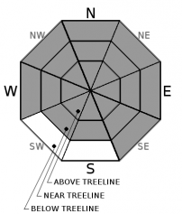
Recent Observations
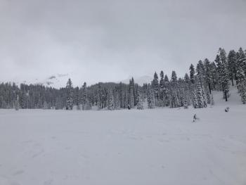
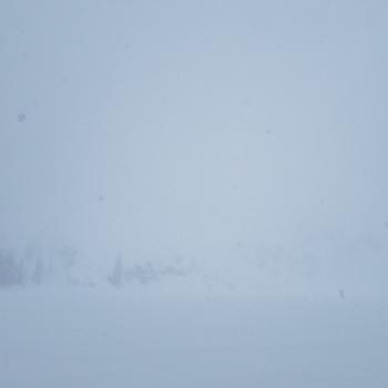
Low visibility and whiteout conditions limited observations near and above treeline yesterday.
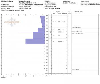
A thin breakable ice crust created by freezing drizzle on Monday sits below new snow throughout the forecast area. This crust could become a bed surface or host future concerns as more snow and weight is added.
Snowpack at the start of yesterday's storm is right side up with F to 1F hardness down to the February 2nd rain crust.
South winds have been cranking near and above treeline. Transporting snow was creating wind drifts up to 24 inches at Castle Lake and on Green Butte Ridge by mid-afternoon yesterday.
Over the last 24 hours, the Old Ski Bowl has received 17 inches of snow. Castle Lake is reporting 20 inches. Temperatures have ranged from 15 to 20 degrees. Temperatures are on the rise. Southerly winds have been light to moderate, but are beginning to move into the strong range. Gray Butte often reports lower wind speeds when winds are from the south. Observations in the field indicate moderate to strong southerly winds near and above treeline.

Weather and Current Conditions
Weather Summary
A large warm storm is currently impacting the forecast area. Winter weather will produce a significant impact on travel and infrastructure today. New snow of 6-14 inches will fall across the forecast area. Snow levels could rise as high as 7,600 feet this afternoon then drop back down to 5,500 feet tonight. There is a chance of a freezing rain event where a warmer section of the storm is expected to move over a colder mass of air.
Southerly winds will remain strong today.
24 Hour Weather Station Data @ 5:00 AM
| Weather Station | Temp (°F) | Wind (mi/hr) | Snow (in) | Comments | ||||||||
|---|---|---|---|---|---|---|---|---|---|---|---|---|
| Cur | Min | Max | Avg | Avg | Max Gust | Dir | Depth | New | Water Equivalent | Settlement | ||
| Mt. Shasta City (3540 ft) | 31 | 27 | 32 | 30.5 | 4 | ESE | ||||||
| Sand Flat (6750 ft) | 23 | 20 | 23 | 22 | 105 | 16 | 0 | 0 | ||||
| Ski Bowl (7600 ft) | 19.5 | 15 | 19.5 | 17.5 | 129 | 17 | 2.54 | 0 | ||||
| Gray Butte (8000 ft) | 18.5 | 15 | 18.5 | 16.5 | 11 | 43 | S | |||||
| Castle Lake (5870 ft) | 22.5 | 20 | 23.5 | 22 | 94 | 20 | 1.5 | |||||
| Mount Eddy (6509 ft) | 20 | 14 | 20 | 16 | 1 | 6 | SSW | 83 | 0 | 0.5 | ||
| Ash Creek Bowl (7250 ft) | station down | |||||||||||
| Ash Creek Ridge (7895 ft) | station down |
Two Day Mountain Weather Forecast
Produced in partnership with the Medford NWS
| For 7000 ft to 9000 ft | |||
|---|---|---|---|
|
Wednesday (4 a.m. to 10 p.m.) |
Wednesday Night (10 p.m. to 4 a.m.) |
Thursday (4 a.m. to 10 p.m.) |
|
| Weather | Windy. Snow and a chance of freezing rain. Chance of snow is 100% | Windy. Snow and a chance of rain. Chance of snow is %100 | Windy. Rain and snow. Chance of snow 90 % |
| Temperature (°F) | 32 | 31 | 31 |
| Wind (mi/hr) | South 25-30 | South 15-20 | Southwest 20-25 |
| Precipitation SWE / Snowfall (in) | / 6-14 | / 4-10 | / 3-6 |
| For 9000 ft to 11000 ft | |||
| Wednesday | Wednesday Night | Thursday | |
| Weather | Windy. Snow The snow could be heavy at times. with a chance of freezing rain. | Windy. Chance of snow %100. | Snow. Wind chill values as low as 6. Very windy and gusty. Chance of precipitation is 90%. |
| Temperature (°F) | 30 | 26 | 28 |
| Wind (mi/hr) | Southwest 45-55 | Southwest 8-14 | Southwest 35-45 |
| Precipitation SWE / Snowfall (in) | / 8-14 | / 4-10 | / 3-6 |
Season Precipitation for Mount Shasta City
| Period | Measured (in) | Normal (in) | Percent of Normal (%) |
|---|---|---|---|
| From Oct 1, 2025 (the wet season) | 18.00 | 25.17 | 72 |
| Month to Date (since Jun 1, 2026) | 4.07 | 2.90 | 140 |
| Year to Date (since Jan 1, 2026) | 9.59 | 9.96 | 96 |

