

You are here
Avalanche Forecast for 2019-02-14 06:10
- EXPIRED ON February 15, 2019 @ 6:10 amPublished on February 14, 2019 @ 6:10 am
- Issued by Ryan Sorenson - Mount Shasta Avalanche Center
Bottom Line
Dangerous avalanche conditions exist today as cold temperatures and continued snowfall impact the forecast area. Periods of snow and strong southerly wind will ripen avalanche conditions. Fresh and lingering wind slabs, storm slabs and cornice avalanche problems will all be of concern today. Human triggered and natural avalanches are likely.


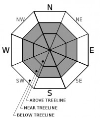
Avalanche Problem 1: Wind Slab
-
Character ?

-
Aspect/Elevation ?
-
Likelihood ?CertainVery LikelyLikelyPossible
 Unlikely
 -
Size ?HistoricVery LargeLargeSmall

Wind slabs have gained size and depth over the last 24 hours. Wind slabs will form on N-NE-E lee aspects and cross-loaded W-NW and S-SE aspects as it continues to storm today. Wind slabs could become large on any aspect above treeline due to local wind variability. Low visibility and travel constraints limited available data on current wind slab formation near and above treeline. However, given the amount of precipitation and constant wind speed seen over the last 48 hours, human and natural wind slab avalanches are likely near and above treeline today. Slopes below or adjacent to cornice features will be most suspect.
A warming temperature trend observed yesterday has likely added strength or avalanched many previously formed wind slabs. Many old wind slabs could linger on leeward terrain. The temperature has steadily risen from 20 degrees Fahrenheit at 4 am yesterday morning to a high around 32 degrees last night at 7,600 feet on the mountain. The temperatures will begin to fall this afternoon as more wind and snow form sensitive fresh wind slabs.
New wind slabs may have the ability to step down into deeper layers of the snowpack if triggered. Look for signs of recently formed wind slabs such as cornice features and wind pillows. Identify and avoid areas where wind slabs exist.
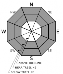
Avalanche Problem 2: Storm Slab
-
Character ?

-
Aspect/Elevation ?
-
Likelihood ?CertainVery LikelyLikelyPossible
Unlikely
-
Size ?HistoricVery LargeLargeSmall
Storm slabs are most common below and near treeline during periods of light or no wind, and/or protected areas. They are the most sensitive during periods of heavy, rapid snow accumulation. Storm Slab avalanches are the release of a cohesive layer (a slab) of new snow that breaks within new snow, or on the old snow surface. The weak point can be snow that fell early in the storm or just a poor bond with the old snow surface.
Yesterday saw periods of heavy wet snow over lighter dry snow. This 20-30 inches of new snow is all positioned over a frozen ice layer from freezing rain on Monday Febuary 11th. Tests results from yesterday point towards instabilities failing and propagating above the ice layer. Any aspect below and near treeline, storm slabs are possible and could be big enough to bury a person and/or sweep one off their feet and into trees, rocks, cliff, etc.
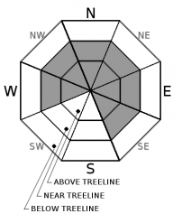
Avalanche Problem 3: Cornice
-
Character ?

-
Aspect/Elevation ?
-
Likelihood ?CertainVery LikelyLikelyPossible
Unlikely
-
Size ?HistoricVery LargeLargeSmall
Watch for cornices along ridgelines today, and as the storm progresses. In general, average wind speeds in the teens are perfect for cornice formation. Use a small wind lip as a test slope. If you are able to trigger small cornices, know that larger ones could be possible. Places like Middle Peak at Castle Lake, Green Butte and Casaval ridgelines, the top of Sun Bowl and Powder Bowl and the north ridge of Gray Butte are all perfect places where unstable cornices might exist.
Forecast Discussion
A near-record of 24 inches of snow in 24 hours was recorded in Mount Shasta City.
For the most detailed weather information, you can visit our nearest NWS office here.
Recent Observations
In the last 24 hours temperatures have ranged from 19 to 31 degrees F near 7,600 feet on Mount Shasta. Steady moderate south-west wind averaging 13 mi/hr, gusting up to 55 mi/hr blew at 8,000 feet. New snow totals are 8.5 inches and the height of snow (HS) at 7,600 feet is 138 inches.
Temperatures at Castle Lake ranged from 22 to 32 degrees F in the last 24 hours near 5,800 feet. New snow totals are 6 inches in the last 24 hours. The height of snow (HS) at 5,800 feet is 98 inches.
- A frozen rain crust from Monday Febuary 11th exists below snow surfaces across the forecast area.
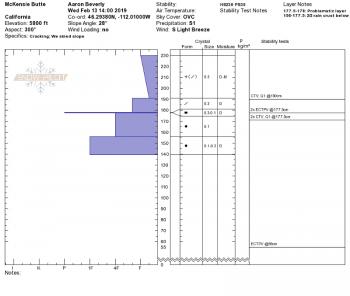
- Test results show instabilities above the rain crust and mid storm pack density changes (see Mckensie Butte observation below).
- Storm snow was measured at 21 inches above this crust at 5,800 feet.
- Storm snow consists of F to 4F hardness above the crust with F hardness below.
- Continued strong southerly winds have been observed over exposed regions across the forecasts area.
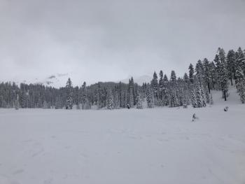
- Limited visibility and difficult travel limited observations near and above treeline yesterday
- Currently at 189% of normal with 5.98 inches of precipitation for February.
- We are at 78% of normal with 19.86 inches of precipitation total out of 25.41 inches normal for the year.

Weather and Current Conditions
Weather Summary
A flood watch is still in effect until 4 p.m. tonight.
Colder temperatures and continued snow will return to the forecast area today. Expect temperatures to fall to the mid 20's this afternoon. This should bring snow levels down to 5,000 feet today.
The storm is beginning to slow down and cool off as another inch of water is expected in the next 24 hours. This will fall as 8-14 inches of new snow above 5,000 feet.
Wind out of the south will continue to blow moderately with strong gusts. Above treeline could see wind speeds as high as 45 mi/hr this afternoon.
24 Hour Weather Station Data @ 4:00 AM
| Weather Station | Temp (°F) | Wind (mi/hr) | Snow (in) | Comments | ||||||||
|---|---|---|---|---|---|---|---|---|---|---|---|---|
| Cur | Min | Max | Avg | Avg | Max Gust | Dir | Depth | New | Water Equivalent | Settlement | ||
| Mt. Shasta City (3540 ft) | 34 | 30 | 37 | 33.5 | 2 | N | ||||||
| Sand Flat (6750 ft) | 32 | 23 | 33 | 29 | 109 | 5 | 0 | 2 | ||||
| Ski Bowl (7600 ft) | 31 | 19 | 31 | 25.5 | 138 | 8.5 | 3.3 | 1 | ||||
| Gray Butte (8000 ft) | 30.5 | 18 | 30.5 | 24.5 | 14 | 55 | SW | |||||
| Castle Lake (5870 ft) | 31 | 22 | 31.5 | 28.5 | 98 | 6 | 1 | |||||
| Mount Eddy (6509 ft) | 29.5 | 28.5 | 33.5 | 30.5 | 3 | 22 | SW | 70 | 8 | .5 | ||
| Ash Creek Bowl (7250 ft) | ||||||||||||
| Ash Creek Ridge (7895 ft) |
Two Day Mountain Weather Forecast
Produced in partnership with the Medford NWS
| For 7000 ft to 9000 ft | |||
|---|---|---|---|
|
Thursday (4 a.m. to 10 p.m.) |
Thursday Night (10 p.m. to 4 a.m.) |
Friday (4 a.m. to 10 p.m.) |
|
| Weather | Snow this morning and snow showers this afternoon, windy. Snow level near 5,000 feet. | Windy with snow showers. Chance of snow near 100%. | Breezy with snow showers and blowing snow. Chance of snow 90% |
| Temperature (°F) | 32 | 21 | 25 |
| Wind (mi/hr) | South 20-25 | South 15-20 | South 15-20 |
| Precipitation SWE / Snowfall (in) | / 8-14 | / 3-6 | / 2-4 |
| For 9000 ft to 11000 ft | |||
| Thursday | Thursday Night | Friday | |
| Weather | Snow, heavy at times. Strong wind | Windy, snow showers. Low wind chill | Blowing snow, windy. |
| Temperature (°F) | 28 and falling | 5 | 15 |
| Wind (mi/hr) | South 40-45 | Southwest 8-14 | Southwest 35-40 |
| Precipitation SWE / Snowfall (in) | / 8-14 | / 3-6 | / 2-4 |
Season Precipitation for Mount Shasta City
| Period | Measured (in) | Normal (in) | Percent of Normal (%) |
|---|---|---|---|
| From Oct 1, 2025 (the wet season) | 19.86 | 25.41 | 78 |
| Month to Date (since Jun 1, 2026) | 5.93 | 3.14 | 189 |
| Year to Date (since Jan 1, 2026) | 11.45 | 10.20 | 112 |

