

You are here
Avalanche Forecast for 2019-02-15 06:33
- EXPIRED ON February 16, 2019 @ 6:33 amPublished on February 15, 2019 @ 6:33 am
- Issued by Nick Meyers - Shasta-Trinity National Forest
Bottom Line
A dangerous and complex snowpack exists in the backcountry. Deep snow, limited access and poor visibility has created uncertainty for near and above treeline terrain. Below treeline observations still indicate ongoing instability. Natural avalanches are possible and human-triggered avalanches are likely. Large, destructive avalanches are possible as continued snow loading occurs. Choose simple terrain, watch your slope angles and pay attention to terrain above you.


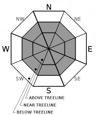
Avalanche Problem 1: Wind Slab
-
Character ?

-
Aspect/Elevation ?
-
Likelihood ?CertainVery LikelyLikelyPossible
 Unlikely
 -
Size ?HistoricVery LargeLargeSmall

New and existing wind slabs have formed on wind-loaded slopes as a result of fresh snow and gale force winds. Near and above treeline NW-N-NE-E-SE aspects above 7,500 ft where the most new snow has accumulated should hold the largest wind slabs. Additional snow and intense, pervasive winds will cause existing wind slabs to grow in size and new wind slabs to form.
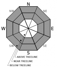
Avalanche Problem 2: Storm Slab
-
Character ?

-
Aspect/Elevation ?
-
Likelihood ?CertainVery LikelyLikelyPossible
Unlikely
-
Size ?HistoricVery LargeLargeSmall
Rapidly changing conditions during the recent days have allowed weak layers and slab layers to form in the storm snow. Storm slab avalanches could occur on any steep slopes on any aspect below and near treeline. Most storm slabs would involve the storm snow but some could entrain older snow especially in lower elevation areas where a weak layer may exist near the Febuary 11th freezing rain crust. Additional snow accumulation could cause new storm slabs to form at lower elevations.
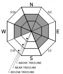
Avalanche Problem 3: Cornice
-
Character ?

-
Aspect/Elevation ?
-
Likelihood ?CertainVery LikelyLikelyPossible
Unlikely
-
Size ?HistoricVery LargeLargeSmall
Winds have been ideal for cornice formation. Everyone knows what a cornice looks like. Where cornices are observed, wind slabs could lurk below. A cornice can often trigger a subsequent wind slab. Picture this: Your walking along a ridgeline, trigger a cornice, tumble onto the slope below triggering a wind slab avalanche...off ya go. Not a happy place to be. Solve all of this by using safe travel techniques. Identify solid ground by looking for rocks and/or trees sticking up through the snowpack.
Forecast Discussion
Spasmodic weather that has included dry powder, freezing rain, rapid warming, heavy precipitation, rain on snow and high wind over the past week has created a complicated snowpack out there. Mentioned already, deep snow, very poor visibility and access issues has created a lot of uncertainty for near and above treeline terrain. Be conservative as access is gained. This old adage always holds true: "When the snowpack is in question, terrain is the answer."
Recent Observations
In the last 24 hours temperatures have cooled off, ranging from 14 to 31 degrees F near 7,600 feet on Mount Shasta. Winds have increased, averaging 19 mi/hr, gusting up to 49 mi/hr at 8,000 feet. New snow: 3-4 inches / Total snow: 141 inches. Temperatures at Castle Lake ranged from 19 to 33 degrees F in the last 24 hours near 5,800 feet. New snow: 2-3 inches. / Total snow: 96 inches.
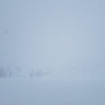
- Conditions at Bunny Flat, noon, Valentines Day (2/14) - New storm snow: 21 inches / Winds: Light / Temp: Below freezing / Visibility: < 1/8 mi / Activity: 4 small D1-D2 storm slab avalanches along road cut just before Bunny Flat / Road: Closed until further notice.
- Top layers of snowpack saturated with dry snow below (upside-down storm layering/slab over weak layer)
- Skier triggered shooting cracks, snowpit tests, recent avalanches and observations have shown ongoing instability
- Access and visibility issues hampering near and above treeline observations over the past two days.
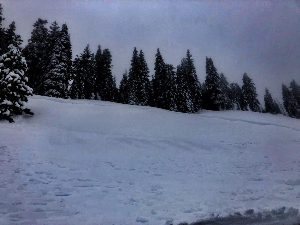
Road cut avalanches just before Bunny Flat trailhead - 2/14/19 - Photo: A Beverly

Weather and Current Conditions
Weather Summary
We are seeing widespread snow showers and a return of cold air to the Mount Shasta area. Snow will continue today, showery in nature, heavy at times, with a gradual decrescendo through the holiday weekend. New snow accumulation will be minimal Saturday and Sunday... low snow levels will stay in place. Generally dryer conditions will host President's Day and the day after (Monday/Tuesday). Another cold system drops in on Wednesday for another round of lower elevation snow potential. This could be followed by yet another cold system...so no indication of busting out of this cold and wet pattern for the moment! We're good with that.
24 Hour Weather Station Data @ 5:00 AM
| Weather Station | Temp (°F) | Wind (mi/hr) | Snow (in) | Comments | ||||||||
|---|---|---|---|---|---|---|---|---|---|---|---|---|
| Cur | Min | Max | Avg | Avg | Max Gust | Dir | Depth | New | Water Equivalent | Settlement | ||
| Mt. Shasta City (3540 ft) | 34 | 30 | 37 | 33.5 | 2 | N | ||||||
| Sand Flat (6750 ft) | 19 | 19 | 33 | 27 | 112 | 3 | 1.2 | .5 | ||||
| Ski Bowl (7600 ft) | 14 | 14 | 31.5 | 23 | 141 | 3 | 1.01 | .5 | ||||
| Gray Butte (8000 ft) | 13 | 13 | 31.5 | 22.5 | 19 | 49 | WSW | |||||
| Castle Lake (5870 ft) | 20 | 19.5 | 33 | 27 | 96 | 2 | .5 | |||||
| Mount Eddy (6509 ft) | 29.5 | 28.5 | 33.5 | 30.5 | 3 | 22 | SW | 70 | 2 | .5 | ||
| Ash Creek Bowl (7250 ft) | ||||||||||||
| Ash Creek Ridge (7895 ft) |
Two Day Mountain Weather Forecast
Produced in partnership with the Medford NWS
| For 7000 ft to 9000 ft | |||
|---|---|---|---|
|
Friday (4 a.m. to 10 p.m.) |
Friday Night (10 p.m. to 4 a.m.) |
Saturday (4 a.m. to 10 p.m.) |
|
| Weather | Breezy, snow showers, areas of blowing snow. Snow levels near 1,000 to 1,500 feet. | Breezy, snow showers, areas of blowing snow. Snow levels near 1,000 to 1,500 feet. | Snow showers. Snow levels near 1,000 to 1,500 feet. |
| Temperature (°F) | 22 | 19 | 24 |
| Wind (mi/hr) | South 10-15 | South 10-15 | West 5-10 |
| Precipitation SWE / Snowfall (in) | / 4-9 | / 5-11 | / 2-4 |
| For 9000 ft to 11000 ft | |||
| Friday | Friday Night | Saturday | |
| Weather | Snow showers, widespread blowing snow. Windy...wind chill values well into the negatives. | Snow showers. Widespread blowing snow. Windy...wind chill value well into the negatives. | Snow showers. Widespread blowing snow. Windy...wind chill values well into the negatives |
| Temperature (°F) | 8 | 7 | 7 |
| Wind (mi/hr) | Southwest 30-35 | Southwest 5-9 | West 25-30 |
| Precipitation SWE / Snowfall (in) | / 5-9 | / 7-11 | / 3-4 |
Season Precipitation for Mount Shasta City
| Period | Measured (in) | Normal (in) | Percent of Normal (%) |
|---|---|---|---|
| From Oct 1, 2025 (the wet season) | 21.23 | 25.67 | 83 |
| Month to Date (since Jun 1, 2026) | 7.30 | 3.40 | 215 |
| Year to Date (since Jan 1, 2026) | 12.82 | 10.46 | 123 |

