

You are here
Avalanche Forecast for 2019-02-18 06:00
- EXPIRED ON February 19, 2019 @ 6:00 amPublished on February 18, 2019 @ 6:00 am
- Issued by Aaron Beverly - Mount Shasta Avalanche Center
Bottom Line
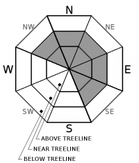
Wind slabs continue to be the main concern near and above treeline. Shooting cracks, blocking, and small test releases are still being observed in parts of the forecast area, though less of this is being seen generally. Evaluate terrain carefully before traveling near or on slopes greater than 35 degrees.


Avalanche Problem 1: Wind Slab
-
Character ?

-
Aspect/Elevation ?
-
Likelihood ?CertainVery LikelyLikelyPossible
 Unlikely
 -
Size ?HistoricVery LargeLargeSmall

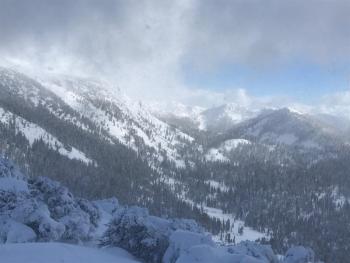
Shooting cracks, blocking, and small test releases were seen in the Eddy's yesterday indicating that a wind slab problem is still lurking. New slabs that formed over last weekend are the primary concern. Slabs formed during and after the 2/13 storm are probably difficult to trigger, but will be large if they are. Easterly facing aspects hold the most snow. Use caution when approaching these slopes if they are greater than 35 degrees.
Forecast Discussion
The snowpack is trending towards increased stability, but cold weather has slowed this process and instabilities still linger. Evaluate the snowpack carefully before entering steep terrain and exercise good group management skills. Ski one at a time, stop in a safe place, and don't ski on top of one another.
Cold clear conditions last night and tonight may cause the formation of hoar frost. Look for it and realize this may create future instabilities as new snow falls.
Recent Observations
Over the last 24 hours, the Old Ski Bowl has received about 0.5 inches of snow. Temperatures ranged from 6 to 27 degrees. Winds have been mostly light near treeline, but blew near and above 20 mi/hr for about 6 hours last night out of the northeast.
Some notable observations on Mount Shasta yesterday:
- Cornices were stubborn to trigger. Very little blocking and no shooting cracks were seen.
- Unusually large wind drifts were present near the edges of terrain features.
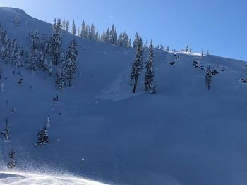
- Gullies and easterly slopes are holding the most snow.
- Snow surfaces range from a couple of inches to a foot of low density snow.
- Northwest winds were transporting snow high on Casaval and Sargent's ridge.
In the Eddy's, wind slab instabilities were still being seen including cracking and blocking.
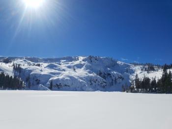
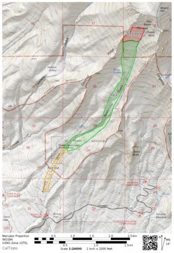
An impressive, very large (R4/D4) avalanche occurred on Wednesday, February 13th, creating a canyon-like runout and up to 30 feet of debris at its terminus below treeline. Low visibility and new snow has prevented an exact determination of the location of the crown, but it likely started off of upper Casaval Ridge and ran down the climber's right gully of Avalanche Gulch. See today's observation for details.
Castle Lake Road is closed. Plow drivers are expected to get it clear sometime this week.
Weather and Current Conditions
Weather Summary
Cold clear conditions are expected today and tomorrow. North winds will be light to moderate.
High pressure out in the Pacific will continue to move cold air from the north, keeping temperatures below freezing throughout the week.
Unsettled weather returns late Tuesday night that should be bring a minor refresh of snow at elevations above 2000 feet.
24 Hour Weather Station Data @ 5:00 AM
| Weather Station | Temp (°F) | Wind (mi/hr) | Snow (in) | Comments | ||||||||
|---|---|---|---|---|---|---|---|---|---|---|---|---|
| Cur | Min | Max | Avg | Avg | Max Gust | Dir | Depth | New | Water Equivalent | Settlement | ||
| Mt. Shasta City (3540 ft) | 25 | 25 | 35 | 28.5 | 5 | |||||||
| Sand Flat (6750 ft) | 7 | 4 | 24 | 13 | 112 | 0 | 0 | 2 | ||||
| Ski Bowl (7600 ft) | 7 | 6 | 26.5 | 12 | 148.7 | 0.5 | 0.19 | 1 | ||||
| Gray Butte (8000 ft) | 9 | 7 | 24.5 | 13 | 10 | 37 | NE | |||||
| Castle Lake (5870 ft) | 14 | 14 | 29 | 18.5 | 95.8 | 1 | 3 | |||||
| Mount Eddy (6509 ft) | ||||||||||||
| Ash Creek Bowl (7250 ft) | station down | |||||||||||
| Ash Creek Ridge (7895 ft) | station down |
Two Day Mountain Weather Forecast
Produced in partnership with the Medford NWS
| For 7000 ft to 9000 ft | |||
|---|---|---|---|
|
Monday (4 a.m. to 10 p.m.) |
Monday Night (10 p.m. to 4 a.m.) |
Tuesday (4 a.m. to 10 p.m.) |
|
| Weather | Sunny. | Mostly clear. | Mostly sunny. |
| Temperature (°F) | 25 | 10 | 25 |
| Wind (mi/hr) | North 5-10 | North 5-10 | North 5-10 |
| Precipitation SWE / Snowfall (in) | / 0 | / 0 | / 0 |
| For 9000 ft to 11000 ft | |||
| Monday | Monday Night | Tuesday | |
| Weather | Sunny. Wind chill values as low as -7. Breezy. | Mostly clear. Wind chill values as low as -7. Breezy. | Mostly sunny. Wind chill values as low as 1. Breezy. |
| Temperature (°F) | 13 | 13 | 19 |
| Wind (mi/hr) | North 20-25 | North 0 | North 20-25 |
| Precipitation SWE / Snowfall (in) | / 0 | / 0 | / 0 |
Season Precipitation for Mount Shasta City
| Period | Measured (in) | Normal (in) | Percent of Normal (%) |
|---|---|---|---|
| From Oct 1, 2025 (the wet season) | 21.61 | 26.49 | 82 |
| Month to Date (since Jun 1, 2026) | 7.68 | 4.22 | 182 |
| Year to Date (since Jan 1, 2026) | 13.20 | 11.28 | 117 |

