

You are here
Avalanche Forecast for 2019-02-22 06:11
- EXPIRED ON February 23, 2019 @ 6:11 amPublished on February 22, 2019 @ 6:11 am
- Issued by Nick Meyers - Shasta-Trinity National Forest
Bottom Line
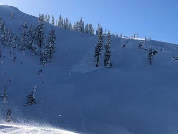
Expect variable snow surfaces and low avalanche risk for Mount Shasta and local area backcountry today. The avalanche danger is low for all elevations and aspects. Use normal caution. Keep your head up for isolated wind slabs in some terrain as well as icy ridgelines and falling rime ice at upper elevations. Fresh snow and W/SW wind will increase throughout the weekend. Expect rising avalanche danger over the coming days.


Avalanche Problem 1: Normal Caution
-
Character ?

-
Aspect/Elevation ?
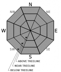
-
Likelihood ?CertainVery LikelyLikelyPossible
 Unlikely
 -
Size ?HistoricVery LargeLargeSmall

Use the ideas of normal caution to safely navigate the winter landscape today.
- Ski and ride one at a time in avalanche terrain. Limit the number exposed to a potential avalanche.
- Don't regroup in avalanche paths or in run out zones. Stay out of harm's way.
- Identify areas of concern and avoid them if necessary.
- Don't expose other to risk.
- Carry rescue equipment (beacon, shovel and probe) and know how to use them. Practice!
Remaining wind slabs and cornices along ridgelines have been difficult to trigger and remain unlikely. Regardless, keep an eye out and use normal caution. Unsupported slopes, gullies, couloirs, cliffy areas and other complex or extreme terrain represent the best places to find a lingering wind slab. If in doubt, bail out!
Forecast Discussion
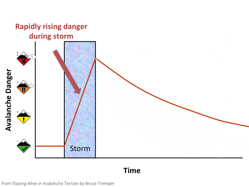
Low danger will continue today. With an incoming storm hosting heavy snow and wind this weekend, we know your inner powder hound is barking...just be sure to heel to rising avalanche danger, or stay on the porch. Woof, woof.
Recent Observations
Yesterday was clear and blue, a holdover day with not much change in snow surfaces or avalanche risk.
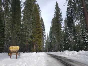
- The road continues to be closed to Castle Lake, though one can skin up the 39N34 road from the gate. We expect the road to open soon.
- Light to moderate and variable wind on Gray Butte
- Strong wind at Castle Lake along ridgelines, blowing snow
- Variable snow surfaces: firm and scoured, wind packed powder, dust on crust, soft powder in protected areas
- No signs of slab instabilities
Weather and Current Conditions
Weather Summary
Get ready folks, winter is far from over, at least for the foreseeable future. A crescendo of snow and wind can be expected into the weekend as the region switches back over into an active and wet weather pattern. An atmospheric river has been mentioned in weather discussions and depending on snow levels, can be a blessing or curse for winter recreation. For this liquid stream moving in Sunday, temps appear to be modest and snow levels should check in around 3,000 to 4,000 feet. Not to shabby. Sunday through Tuesday, over 2.5 inches of water is forecast, which means several feet of additional snow in the high country. Let's pump the brakes on all this for now, because it's Friday. For today, mostly sunny skies will give way to increasing clouds this afternoon. Temps are a touch warmer than yesterday. Our north wind has died off and become light and variable, though not for long. Count on winds to line back up and increase out of the north today, swinging around to the west tonight and southwest tomorrow.
24 Hour Weather Station Data @ 4:00 AM
| Weather Station | Temp (°F) | Wind (mi/hr) | Snow (in) | Comments | ||||||||
|---|---|---|---|---|---|---|---|---|---|---|---|---|
| Cur | Min | Max | Avg | Avg | Max Gust | Dir | Depth | New | Water Equivalent | Settlement | ||
| Mt. Shasta City (3540 ft) | 23 | 23 | 38 | 29 | 4 | |||||||
| Sand Flat (6750 ft) | 10 | 5 | 22 | 13 | 111 | 0 | 0 | 0 | ||||
| Ski Bowl (7600 ft) | 6.5 | 5.5 | 21 | 12 | 145 | 0 | 0 | .5 | ||||
| Gray Butte (8000 ft) | 10.5 | 8.5 | 18.5 | 11.5 | 10 | 37 | NNE | |||||
| Castle Lake (5870 ft) | 9.5 | 9.5 | 26.5 | 16.5 | 97 | 0 | .5 | |||||
| Mount Eddy (6509 ft) | ||||||||||||
| Ash Creek Bowl (7250 ft) | station down | |||||||||||
| Ash Creek Ridge (7895 ft) | station down |
Two Day Mountain Weather Forecast
Produced in partnership with the Medford NWS
| For 7000 ft to 9000 ft | |||
|---|---|---|---|
|
Friday (4 a.m. to 10 p.m.) |
Friday Night (10 p.m. to 4 a.m.) |
Saturday (4 a.m. to 10 p.m.) |
|
| Weather | Mostly sunny | Partly cloudy, increasing clouds | Chance of snow, mostly cloudy. Increasing snow and wind into Sunday |
| Temperature (°F) | 29 | 17 | 28 |
| Wind (mi/hr) | North 5-10 | West 5-10 | Southwest 5-10 |
| Precipitation SWE / Snowfall (in) | / 0 | / 0 | / 1-3 |
| For 9000 ft to 11000 ft | |||
| Friday | Friday Night | Saturday | |
| Weather | Mostly sunny, windy | Partly cloudy, increasing clouds, windy | Chance of snow, mostly cloudy, increasing snow and wind into Sunday. |
| Temperature (°F) | 16 | 14 | 15 |
| Wind (mi/hr) | North 20-30 | Northwest 0 | West 20-30 |
| Precipitation SWE / Snowfall (in) | / 0 | / 0 | / 2-4 |
Season Precipitation for Mount Shasta City
| Period | Measured (in) | Normal (in) | Percent of Normal (%) |
|---|---|---|---|
| From Oct 1, 2025 (the wet season) | 21.81 | 27.60 | 79 |
| Month to Date (since Jun 1, 2026) | 7.88 | 5.33 | 148 |
| Year to Date (since Jan 1, 2026) | 13.40 | 12.39 | 108 |

