

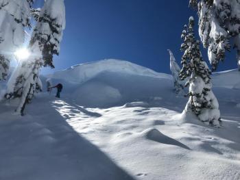
You are here
Avalanche Forecast for 2019-02-24 06:00
- EXPIRED ON February 25, 2019 @ 6:00 amPublished on February 24, 2019 @ 6:00 am
- Issued by Aaron Beverly - Mount Shasta Avalanche Center
Bottom Line
An atmospheric river event will affect the forecast area for the next four days. Close to six inches of precipitable water is expected. Snow levels should remain near 4000 feet. Avalanche danger will rise today as wind slabs and storm slabs begin to form. Evaluate the snowpack carefully as you travel. Be conservative. Avoid steep terrain.


Avalanche Problem 1: Wind Slab
-
Character ?

-
Aspect/Elevation ?
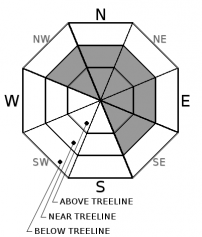
-
Likelihood ?CertainVery LikelyLikelyPossible
 Unlikely
 -
Size ?HistoricVery LargeLargeSmall

Concern for wind slabs will rise today as 5-16 inches of snow combines with south and west winds. There are firm bed surfaces out there with a bit of light snow on top. This configuration may not support the weight of new wind slabs.
Pay attention to where leeward areas reside. Stay away from steep slopes that have been loaded. Look for signs of the wind slab problem as you travel in safe terrain:
- Shooting cracks, blocking, whumphing
- Convex pillows of wind-drifted snow
- Chalky, hollow sounding snow
Avalanche Problem 2: Storm Slab
-
Character ?

-
Aspect/Elevation ?
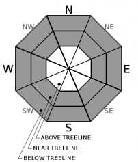
-
Likelihood ?CertainVery LikelyLikelyPossible
Unlikely
-
Size ?HistoricVery LargeLargeSmall
Enough snow will fall today to create a concern for storm slabs. You may find them near and below treeline, in wind protected areas, on very steep slopes approaching 40 degrees. The chutes on Gray Butte just right of the big trees is a common place to trigger them.
Storm slabs are a release of a soft cohesive layer of new snow that breaks within the storm snow or on the old snow surface. Storm-slab problems typically last between a few hours and few days.
Forecast Discussion
Your awareness should be heightened over the next few days. Remember the five red flags for avalanche danger:
- Recent avalanches
- Cracking, blocking, whumphing
- Significant snowfall in 24 hours
- Strong winds
- Temperature rise
Recent Observations
Over the last 24 hours, the Old Ski Bowl has received about 1/2 inch of snow. Temperatures ranged from 18 to 23 degrees. West/northwest winds have been moderate, blowing 16 - 21 mi/hr, gusting up to 31.
Snow surfaces are a mix of firm and scoured, wind board, dust on crust, and soft and light in protected areas. A breakable wind crust exists on south and southeast aspects near and above treeline. No signs of instability have been seen in recent days.
Castle Lake Road is open.

Weather and Current Conditions
Weather Summary
Hold on to your paddles. An atmospheric river is flowing our way. Close to 6 inches of precipitable water is expected by Thursday morning. A blob of low pressure parked off the coast of Washington will deliver continuous moisture for the next several days.
In the next 24 hours, expect 5-16 inches of snow above 4000 feet. South and west winds will be moderate to strong. Temperatures near treeline will be just below freezing.
24 Hour Weather Station Data @ 5:00 AM
| Weather Station | Temp (°F) | Wind (mi/hr) | Snow (in) | Comments | ||||||||
|---|---|---|---|---|---|---|---|---|---|---|---|---|
| Cur | Min | Max | Avg | Avg | Max Gust | Dir | Depth | New | Water Equivalent | Settlement | ||
| Mt. Shasta City (3540 ft) | 33 | 30 | 37 | 33.5 | 4 | ESE | ||||||
| Sand Flat (6750 ft) | 10 | 5 | 22 | 13 | 111 | 0 | 0 | 0 | ||||
| Ski Bowl (7600 ft) | 19 | 16.5 | 23 | 18.5 | 135.3 | 0.5 | 0.02 | 0 | ||||
| Gray Butte (8000 ft) | 18 | 13.5 | 19 | 16.5 | 16 | 31 | WNW | |||||
| Castle Lake (5870 ft) | 24 | 21.5 | 35.5 | 25.5 | 94.6 | 0 | 0.5 | |||||
| Mount Eddy (6509 ft) | ||||||||||||
| Ash Creek Bowl (7250 ft) | station down | |||||||||||
| Ash Creek Ridge (7895 ft) | station down |
Two Day Mountain Weather Forecast
Produced in partnership with the Medford NWS
| For 7000 ft to 9000 ft | |||
|---|---|---|---|
|
Sunday (4 a.m. to 10 p.m.) |
Sunday Night (10 p.m. to 4 a.m.) |
Monday (4 a.m. to 10 p.m.) |
|
| Weather | Snow. Breezy. Chance of precipitation is 100%. | Snow. Breezy. Chance of precipitation is 90%. | Snow. The snow could be heavy at times. Windy. Chance of precipitation is 100%. |
| Temperature (°F) | 28 | 25 | 29 |
| Wind (mi/hr) | South 10-15 | South 15-20 | South 20-25 |
| Precipitation SWE / Snowfall (in) | / 2-4 | / 3-6 | / 3-7 |
| For 9000 ft to 11000 ft | |||
| Sunday | Sunday Night | Monday | |
| Weather | Snow. Windy and gusty. Chance of precipitation is 100%. | Snow. Windy and gusty. Chance of precipitation is 90%. | Snow. Windy and gusty. Chance of precipitation is 100%. |
| Temperature (°F) | 19 | 19 | 22 |
| Wind (mi/hr) | West 25-35 | Southwest 3-6 | Southwest 45-55 |
| Precipitation SWE / Snowfall (in) | / 3-6 | / 5-8 | / 6-10 |
Season Precipitation for Mount Shasta City
| Period | Measured (in) | Normal (in) | Percent of Normal (%) |
|---|---|---|---|
| From Oct 1, 2025 (the wet season) | 21.81 | 27.87 | 78 |
| Month to Date (since Jun 1, 2026) | 7.88 | 5.60 | 141 |
| Year to Date (since Jan 1, 2026) | 13.40 | 12.66 | 106 |

