

You are here
Avalanche Forecast for 2019-02-25 06:00
- EXPIRED ON February 26, 2019 @ 6:00 amPublished on February 25, 2019 @ 6:00 am
- Issued by Aaron Beverly - Mount Shasta Avalanche Center
Bottom Line
The atmospheric river will become more intense today bringing 7-21 inches of snow above 4000 feet. Avalanche danger is heightened. Wind slabs and storm slabs are the primary concern. Evaluate the snowpack carefully as you travel in safe terrain. Be conservative. Avoid steep aspects. Be mindful of what is above you. Avalanches can travel long distances.


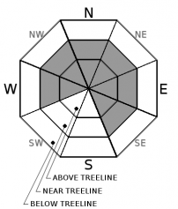
Avalanche Problem 1: Wind Slab
-
Character ?

-
Aspect/Elevation ?
-
Likelihood ?CertainVery LikelyLikelyPossible
 Unlikely
 -
Size ?HistoricVery LargeLargeSmall

With 8 inches of snow in the last 24 hours and potentially 20 inches of snow today coupled with moderate to strong southerly winds, expect wind slabs to continue to grow. Wind slabs can be three times as thick as the amount of snow that falls. Snow underneath is a mix of light density snow and crusts. This will not easily support the weight of new heavier snow.
Pay attention to where leeward areas reside. Stay away from steep slopes that have been loaded. Look for signs of the wind slab problem as you travel in safe terrain:
- Shooting cracks, blocking, whumphing
- Convex pillows of wind-drifted snow
- Chalky, hollow sounding snow
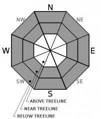
Avalanche Problem 2: Storm Slab
-
Character ?

-
Aspect/Elevation ?
-
Likelihood ?CertainVery LikelyLikelyPossible
Unlikely
-
Size ?HistoricVery LargeLargeSmall
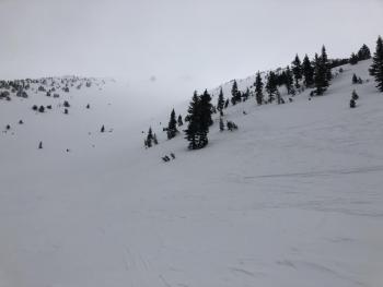
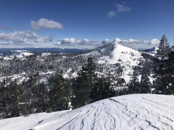
The warming storm will bring significant snow today creating an upside down configuration in the snow pack. These conditions are notorious for creating storm slabs. You may find them near and below treeline, in wind protected areas, on very steep slopes approaching 40 degrees. The chutes on Gray Butte just right of the big trees is a common place to trigger them.
Storm slabs are a release of a soft cohesive layer of new snow that breaks within the storm snow or on the old snow surface. Storm-slab problems typically last between a few hours and few days.
Forecast Discussion
Your awareness should be heightened over the next few days. Avoiding steep terrain is advisable, but also be aware of what is above you. Avalanches can travel long distances. Remember the five red flags for avalanche danger:
- Recent avalanches
- Cracking, blocking, whumphing *
- Significant snowfall in 24 hours *
- Strong winds *
- Temperature rise
* - Have been observed and/or are expected today
Recent Observations
Over the last 24 hours, the Old Ski Bowl has received 8 inches of snow. Temperatures ranged from 18 to 23 degrees. West and southwest winds have been moderate, averaging 16 mi/hr and gusting up to 31.
At 1 p.m. yesterday, winds at Castle Lake were strong and blowing primarily from the south, but at times seemed to come from all directions. Upper regions of Left Peak were becoming cross loaded with soft wind slabs up to 4 inches thick. Blocking from 1 to 4 inches was observed in wind affected areas. Small wind slabs were easy to trigger on northeast aspects of Right Peak.
Column tests on Gray Butte did not indicate any notable signs of instability, though near surface snow configurations may not support significant amounts of new heavy snow.


Weather and Current Conditions
Weather Summary
A winter storm warning is effect until 10 p.m.
The atmospheric river will increase its intensity today bringing 7-21 inches above 4000 feet in the next 24 hours. Southerly winds will be strong and could reach gale force speeds above treeline. Temperatures will be just below freezing near treeline.
Point forecasts are predicting 24-34 inches of snow in the next 24 hours. We feel this is a bit optimistic and are sticking with our numbers.
24 Hour Weather Station Data @ 5:00 AM
| Weather Station | Temp (°F) | Wind (mi/hr) | Snow (in) | Comments | ||||||||
|---|---|---|---|---|---|---|---|---|---|---|---|---|
| Cur | Min | Max | Avg | Avg | Max Gust | Dir | Depth | New | Water Equivalent | Settlement | ||
| Mt. Shasta City (3540 ft) | 34 | 32 | 35.5 | 33.5 | 6 | ESE | ||||||
| Sand Flat (6750 ft) | 10 | 5 | 22 | 13 | 111 | 0 | 0 | 0 | ||||
| Ski Bowl (7600 ft) | 21.5 | 19 | 22.5 | 21 | 142.7 | 8.3 | 0.75 | 0.9 | ||||
| Gray Butte (8000 ft) | 20.5 | 18 | 21.5 | 20 | 16 | 37 | WSW | |||||
| Castle Lake (5870 ft) | 26.5 | 23.5 | 29.5 | 26.5 | 107.2 | 13 | 0.4 | |||||
| Mount Eddy (6509 ft) | ||||||||||||
| Ash Creek Bowl (7250 ft) | station down | |||||||||||
| Ash Creek Ridge (7895 ft) | station down |
Two Day Mountain Weather Forecast
Produced in partnership with the Medford NWS
| For 7000 ft to 9000 ft | |||
|---|---|---|---|
|
Monday (4 a.m. to 10 p.m.) |
Monday Night (10 p.m. to 4 a.m.) |
Tuesday (4 a.m. to 10 p.m.) |
|
| Weather | Snow. The snow could be heavy at times. Windy. Chance of precipitation is 100%. | Snow. The snow could be heavy at times. Chance of precipitation is 100%. | Snow. The snow could be heavy at times. Chance of precipitation is 100%. |
| Temperature (°F) | 28 | 16 | 28 |
| Wind (mi/hr) | South 25-30 | Southwest 5-10 | South 5-10 |
| Precipitation SWE / Snowfall (in) | / 4-8 | / 3-6 | / 3-7 |
| For 9000 ft to 11000 ft | |||
| Monday | Monday Night | Tuesday | |
| Weather | Snow. The snow could be heavy at times. Very windy and gusty. Chance of precipitation is 100%. | Snow. The snow could be heavy at times. Windy and gusty. Chance of precipitation is 100%. | Snow. The snow could be heavy at times. Windy and gusty. Chance of precipitation is 100%. |
| Temperature (°F) | 18 | 10 | 18 |
| Wind (mi/hr) | Southwest 50-60 | Southwest 7-12 | Southwest 30-40 |
| Precipitation SWE / Snowfall (in) | / 7-12 | / 6-9 | / 6-11 |
Season Precipitation for Mount Shasta City
| Period | Measured (in) | Normal (in) | Percent of Normal (%) |
|---|---|---|---|
| From Oct 1, 2025 (the wet season) | 21.97 | 28.42 | 77 |
| Month to Date (since Jun 1, 2026) | 8.04 | 6.15 | 131 |
| Year to Date (since Jan 1, 2026) | 13.56 | 13.21 | 103 |

