

You are here
Avalanche Forecast for 2019-02-26 06:00
- EXPIRED ON February 27, 2019 @ 6:00 amPublished on February 26, 2019 @ 6:00 am
- Issued by Aaron Beverly - Mount Shasta Avalanche Center
Bottom Line
The storm intensifies today and tonight, bringing with it up to 4 feet of snow in 24 hours to elevations above 4,000 feet. Natural and human-triggered avalanches are likely. They could be very large and may travel long distances. Travel in, near, or below avalanche terrain is not recommended.


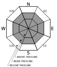
Avalanche Problem 1: Wind Slab
-
Character ?

-
Aspect/Elevation ?
-
Likelihood ?CertainVery LikelyLikelyPossible
 Unlikely
 -
Size ?HistoricVery LargeLargeSmall

We have received 17 inches of new snow in the last 24 hours and 27 inches since the current storm started. Up to 4 feet of snow may fall today. Southerly winds have been and will be productive. New winds slabs could be very large. Snow underneath them is a mix of light density snow and crusts. This will not easily support their weight.
Pay attention to where leeward areas reside. Stay far away from steep slopes that have been loaded. Look for signs of the wind slab problem as you travel in safe terrain:
- Shooting cracks, blocking, whumphing
- Convex pillows of wind-drifted snow
- Chalky, hollow sounding snow
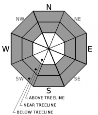
Avalanche Problem 2: Storm Slab
-
Character ?

-
Aspect/Elevation ?
-
Likelihood ?CertainVery LikelyLikelyPossible
Unlikely
-
Size ?HistoricVery LargeLargeSmall
Yesterday's temperatures started colder than expected. With rising snow levels today, expect an upside down configuration in the snowpack near and below treeline. This configuration commonly leads to storm slab formation. Column tests indicate a weakness in the snowpack at the old/new snow interface which, at the time, was 70 cm (28 inches) below the snow surface. New snow yesterday was cohesive enough to create propagating soft slabs at this weak interface. Heavier snow today will exacerbate the problem. These avalanches could be very large.
You may find storm slabs on steep slopes near and below treeline, in wind protected areas.
Storm slabs are a release of a soft cohesive layer of new snow that breaks within the storm snow or on the old snow surface. Storm-slab problems typically last between a few hours and few days.
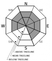
Avalanche Problem 3: Cornice
-
Character ?

-
Aspect/Elevation ?
-
Likelihood ?CertainVery LikelyLikelyPossible
Unlikely
-
Size ?HistoricVery LargeLargeSmall
When wind slabs are forming, cornices are usually growing. Significant snow and strong southerly winds will combine to add weight and size to already large cornices. If these break, they'll be big and will likely trigger a wind slab avalanche. Steer well clear of these over the next few days.
Forecast Discussion
With the sheer amount of snow that has fallen and is expected to fall, you may see some unusual conditions out there today. Avalanches could be very large. Runouts may be long. Slabs and cornices could break further back from ridgetops than expected. Avalanches may slide on lower angle slopes than typical. Stick to terrain under 30 degrees. Travel in, near, or below avalanche terrain in not recommended.
A similar configuration is developing in our forecast area that we saw prior to the Valentine Avalanche - significant snow followed by warming temperatures. Temperatures will not spike as they did during that event, but we will receive much more snow during this storm. Weaknesses have been seen in the snowpack and it may not support the weight of several feet of new snow.
Make conservative decisions today and remember the five red flags for avalanche danger:
- Recent avalanches **
- Cracking, blocking, whumphing *
- Significant snowfall in 24 hours *
- Strong winds *
- Temperature rise **
* - Have been observed; ** - are expected today
Recent Observations
Over the last 24 hours, the Old Ski Bowl has received 17 inches of snow. Storm totals are at 27 inches. Temperatures ranged from 22 to 26 degrees. West and southwest winds have been moderate, averaging 19 mi/hr and gusting up to 31.
Snow levels yesterday were much lower than expected, though by the evening, they had risen to 4,000 feet.
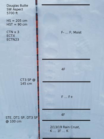
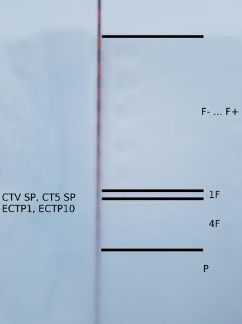
Column tests were easy to trigger below treeline on Coyote Butte yesterday at 2 p.m. Failures propagated and consistently occurred just below a 1F hard breakable crust about 70 cm (28 in) down.
Shooting cracks were observed in wind affected areas at the top of Coyote Butte.
No official word has been received on the status of Everitt Memorial and Castle Lake Roads, but plan on them being closed today.

Weather and Current Conditions
Weather Summary
A winter storm warning is effect until 10 p.m. Wednesday above 4,000 ft.
If you thought yesterday was wild, you better hang on. Over 3 inches of preciptiable water is expected in the next 24 hours. Near snow level elevations could see 15 inches of snow. High elevations could receive as much as 4 feet. Plan on strong southerly winds above treeline.
24 Hour Weather Station Data @ 5:00 AM
| Weather Station | Temp (°F) | Wind (mi/hr) | Snow (in) | Comments | ||||||||
|---|---|---|---|---|---|---|---|---|---|---|---|---|
| Cur | Min | Max | Avg | Avg | Max Gust | Dir | Depth | New | Water Equivalent | Settlement | ||
| Mt. Shasta City (3540 ft) | 35 | 33 | 37 | 34.5 | 4 | ESE | ||||||
| Sand Flat (6750 ft) | station not responding | |||||||||||
| Ski Bowl (7600 ft) | 26.5 | 21.5 | 26.5 | 23.5 | 159.5 | 17 | 2.08 | 1.2 | ||||
| Gray Butte (8000 ft) | 26 | 20.5 | 26 | 22 | 19 | 37 | SW | |||||
| Castle Lake (5870 ft) | 31 | 26 | 31 | 28.5 | 124.1 | 16 | 0.3 | |||||
| Mount Eddy (6509 ft) | ||||||||||||
| Ash Creek Bowl (7250 ft) | station down | |||||||||||
| Ash Creek Ridge (7895 ft) | station down |
Two Day Mountain Weather Forecast
Produced in partnership with the Medford NWS
| For 7000 ft to 9000 ft | |||
|---|---|---|---|
|
Tuesday (4 a.m. to 10 p.m.) |
Tuesday Night (10 p.m. to 4 a.m.) |
Wednesday (4 a.m. to 10 p.m.) |
|
| Weather | Snow. The snow could be heavy at times. Blustery. Chance of precipitation is 100%. | Snow. The snow could be heavy at times. Windy. Temperature rising to around 30 by 4 a.m. Chance of precipitation is 100%. | Snow showers. The snow could be heavy at times. Blustery. Chance of precipitation is 90%. |
| Temperature (°F) | 25 | 30 | 33 |
| Wind (mi/hr) | South 15-20 | South 20-25 | South 15-20 |
| Precipitation SWE / Snowfall (in) | / 7-15 | / 8-17 | / 3-7 |
| For 9000 ft to 11000 ft | |||
| Tuesday | Tuesday Night | Wednesday | |
| Weather | Snow. The snow could be heavy at times. Windy and gusty. Chance of precipitation is 100%. | Snow. The snow could be heavy at times. Windy and gusty. Chance of precipitation is 100%. | Snow showers. The snow could be heavy at times. Windy and gusty. Chance of precipitation is 90%. |
| Temperature (°F) | 22 | 18 | 20 |
| Wind (mi/hr) | South 25-30 | South 14-22 | South 30-35 |
| Precipitation SWE / Snowfall (in) | / 14-22 | / 16-25 | / 7-12 |
Season Precipitation for Mount Shasta City
| Period | Measured (in) | Normal (in) | Percent of Normal (%) |
|---|---|---|---|
| From Oct 1, 2025 (the wet season) | 22.13 | 28.42 | 78 |
| Month to Date (since Jun 1, 2026) | 8.20 | 6.15 | 133 |
| Year to Date (since Jan 1, 2026) | 13.72 | 13.21 | 104 |

