

You are here
Avalanche Forecast for 2019-03-12 06:00
- EXPIRED ON March 13, 2019 @ 6:00 amPublished on March 12, 2019 @ 6:00 am
- Issued by Aaron Beverly - Mount Shasta Avalanche Center
Bottom Line
Natural and human-triggered avalanches are unlikely. Watch for unstable snow in isolated terrain. Exercise normal caution. Widespread crusts exist near and below treeline. Though an inch of snow may fall today, dry conditions will prevail until next week.


Avalanche Problem 1: Normal Caution
-
Character ?

Natural and human-triggered avalanches are unlikely but continue to watch for unstable snow in isolated areas or in extreme terrain. Otherwise exercise normal caution:
- Have a plan, stick to the plan.
- Travel one at a time on and below steep slopes.
- Bring the gear and skills necessary for avalanche rescue.
Forecast Discussion
Lingering snow showers may bring a skiff of snow today, but otherwise expect drier weather for the next week. We may even get to a corn cycle by the end of it.
Bundle up if heading into the alpine regions. It'll be cold up there today and tonight. Trees and outcroppings at the tops of ridges are heavily rimed. If things warm up this week, beware of falling ice.
As of yesterday afternoon at 4:30 p.m., Castle Lake Road was closed, though plow drivers were still working on it. We suspect it will be open today or tomorrow.
Sand Flat weather station is back on-line.
Recent Observations
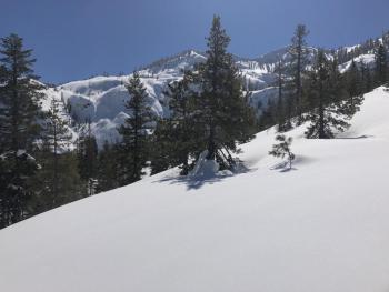
Temperatures rose above freezing yesterday (max 40 °F) for several hours near treeline and a clear day exposed the surface snow to several hours of solar radiation. Widespread crusts were found near and below treeline. North facing aspects shielded from any sun exposure still held dry surface snow. At the Old Ski Bowl, snow has settled by over 3 inches.
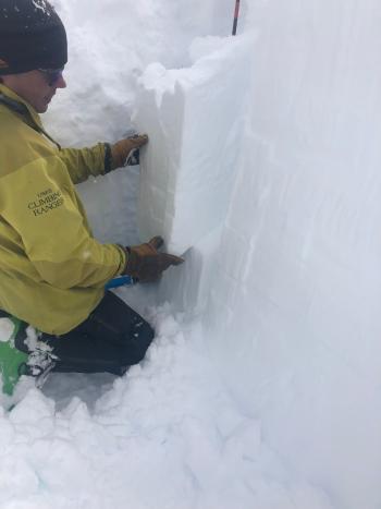
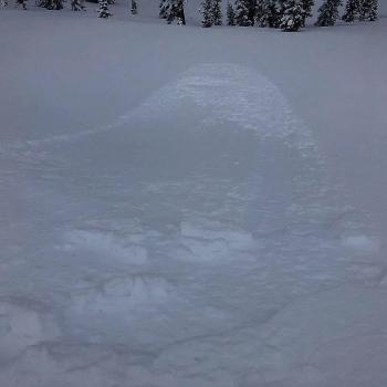
Aside from some roller balls, no signs of instability were seen. Column and block tests did not yield notable results aside from easy failures between surface crusts and unbonded snow beneath. This would only be a concern if significant snow was received on top.
Weather and Current Conditions
Weather Summary
A cold front moves into the area today that will drag freezing levels as low as 2,500 feet by this afternoon. Moderate to strong northwest winds are expected above treeline creating below zero wind chills. Less than an inch of snow is expected.
Dry weather should prevail until next week.
24 Hour Weather Station Data @ 4:00 AM
| Weather Station | Temp (°F) | Wind (mi/hr) | Snow (in) | Comments | ||||||||
|---|---|---|---|---|---|---|---|---|---|---|---|---|
| Cur | Min | Max | Avg | Avg | Max Gust | Dir | Depth | New | Water Equivalent | Settlement | ||
| Mt. Shasta City (3540 ft) | 35 | 24 | 54 | 38 | 2 | N | ||||||
| Sand Flat (6750 ft) | 25 | 12 | 51 | 28 | 147 | 0 | 0 | 3 | ||||
| Ski Bowl (7600 ft) | 28 | 21 | 39.5 | 29.5 | 183.7 | 0 | 0 | 3.2 | ||||
| Gray Butte (8000 ft) | 25 | 22 | 36 | 28.5 | 11 | 37 | E | |||||
| Castle Lake (5870 ft) | 33.5 | 22 | 42.5 | 34 | 146.5 | 2.1 | 2.9 | |||||
| Mount Eddy (6509 ft) | 29 | 15 | 38 | 28.5 | 2 | 6 | WSW | 139.6 | 0 | 1 | ||
| Ash Creek Bowl (7250 ft) | ||||||||||||
| Ash Creek Ridge (7895 ft) |
Two Day Mountain Weather Forecast
Produced in partnership with the Medford NWS
| For 7000 ft to 9000 ft | |||
|---|---|---|---|
|
Tuesday (4 a.m. to 10 p.m.) |
Tuesday Night (10 p.m. to 4 a.m.) |
Wednesday (4 a.m. to 10 p.m.) |
|
| Weather | Snow likely before 11 a.m., then snow showers likely after 11 a.m. Partly sunny. Chance of precipitation is 70%. | Partly cloudy. | Sunny. |
| Temperature (°F) | 27 | 17 | 34 |
| Wind (mi/hr) | Northwest 5-10 | Northwest 10-15 | North 10-15 |
| Precipitation SWE / Snowfall (in) | / 1 | / 0 | / 0 |
| For 9000 ft to 11000 ft | |||
| Tuesday | Tuesday Night | Wednesday | |
| Weather | Snow before 11 a.m., then snow showers likely after 11 a.m. Windy and gusty. Below zero wind chills. Chance of precipitation is 80%. | Partly cloudy. Windy and gusty. Below zero wind chills. | Sunny. Windy and gusty. Below zero wind chills. |
| Temperature (°F) | Decreasing to 9 | 7 | 21 |
| Wind (mi/hr) | West 25-30 | Northwest 1 | North 35-40 |
| Precipitation SWE / Snowfall (in) | / 1 | / 0 | / 0 |
Season Precipitation for Mount Shasta City
| Period | Measured (in) | Normal (in) | Percent of Normal (%) |
|---|---|---|---|
| From Oct 1, 2025 (the wet season) | 31.70 | 32.15 | 99 |
| Month to Date (since Jun 1, 2026) | 2.17 | 2.65 | 82 |
| Year to Date (since Jan 1, 2026) | 23.29 | 16.94 | 137 |

