

You are here
Avalanche Forecast for 2019-03-20 06:30
- EXPIRED ON March 21, 2019 @ 6:30 amPublished on March 20, 2019 @ 6:30 am
- Issued by Aaron Beverly - Mount Shasta Avalanche Center
Bottom Line
New snow and strong south winds could create small wind slabs above treeline on steep leeward slopes. It is possible for these to be human-triggered. Evaluate snow and terrain carefully if ascending above treeline today.


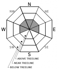
Avalanche Problem 1: Wind Slab
-
Character ?

-
Aspect/Elevation ?
-
Likelihood ?CertainVery LikelyLikelyPossible
 Unlikely
 -
Size ?HistoricVery LargeLargeSmall

A couple of inches of snow has fallen above treeline in the last 24 hours. Up to 4 inches could fall today. This is not a significant amount, but strong south winds could contribute to the formation of small slabs on the lee side of ridges. Stomp on wind drifted snow on rollovers in safe terrain. Does it crack or release blocks of snow? If so, wind slabs may be forming nearby. Be especially careful above treeline on leeward slopes greater than 35 degrees.
Forecast Discussion
To at least 10,000 feet, expect smooth, rain and melt-freeze crusts to be widespread underneath new snow. These will provide ideal bed surfaces for any new snow to slide on if it has not bonded well. Because of the warm crusts, warm storm, and falling temperatures, this bond should be solid near and below treeline.
If you are interested in learning more about Monday's wet slab avalanche just below Bunny Flat, checkout the official report.
Recent Observations
In the last 24 hours, temperatures near 7,000 ft have ranged from 35 to 49 °F. About a quarter of inch of rain was received.
Surface snow near and below treeline yesterday was soft and wet with boot penetration up to 4 inches.
No new signs of instability were observed, though some small point releases and roller balls from prior days were seen on steep slopes around Castle Lake.
Castle Lake Road is open.
Castle Lake weather station is back on-line, though we are currently experiencing some communication difficulties with our weather stations. Sand Flat weather station has the most current data.

Weather and Current Conditions
Weather Summary
A low pressure trough will continue to bring wet air from the south today. Snow levels should drop to 5,500 ft and up to 4 inches of snow could fall at higher elevations by tonight. Expect moderate to strong south winds above treeline.
Tomorrow no precipitation of note is expected and conditions will be so calm you'll be able to light a candle above treeline.
24 Hour Weather Station Data @ 11:00 AM
| Weather Station | Temp (°F) | Wind (mi/hr) | Snow (in) | Comments | ||||||||
|---|---|---|---|---|---|---|---|---|---|---|---|---|
| Cur | Min | Max | Avg | Avg | Max Gust | Dir | Depth | New | Water Equivalent | Settlement | ||
| Mt. Shasta City (3540 ft) | 40 | 29 | 66 | 47 | 1 | N | ||||||
| Sand Flat (6750 ft) | 36 | 35 | 49 | 41 | 130 | 1 | 0.2 | 3 | ||||
| Ski Bowl (7600 ft) | 38.5 | 35.5 | 38.5 | 37 | 166.7 | 0 | 0 | 0.4 | communication stopped at 12:00 p.m. | |||
| Gray Butte (8000 ft) | 39.5 | 35 | 39.5 | 37 | 22 | 31 | ESE | communication stopped at 12:00 p.m. | ||||
| Castle Lake (5870 ft) | 56.5 | 39.5 | 56.5 | 47 | 131.3 | 51.4 | 52.7 | communication stopped at 12:00 p.m. | ||||
| Mount Eddy (6509 ft) | 44 | 36.5 | 46 | 41 | 2 | 7 | WSW | 128.1 | 0.6 | 1 | ||
| Ash Creek Bowl (7250 ft) | ||||||||||||
| Ash Creek Ridge (7895 ft) |
Two Day Mountain Weather Forecast
Produced in partnership with the Medford NWS
| For 7000 ft to 9000 ft | |||
|---|---|---|---|
|
Wednesday (4 a.m. to 10 p.m.) |
Wednesday Night (10 p.m. to 4 a.m.) |
Thursday (4 a.m. to 10 p.m.) |
|
| Weather | Snow showers. Chance of precipitation is 90%. | A 40 percent chance of snow showers, mainly before 11 p.m. Mostly cloudy. | A 30 percent chance of snow showers, mainly after 11 a.m. Partly sunny. |
| Temperature (°F) | 33 | 28 | 38 |
| Wind (mi/hr) | South 5-10 | South 5-10 | Southwest 0-5 |
| Precipitation SWE / Snowfall (in) | / 1-3 | / < 0.5 | / 0 |
| For 9000 ft to 11000 ft | |||
| Wednesday | Wednesday Night | Thursday | |
| Weather | Snow showers. Windy and gusty. Low wind chills. Chance of precipitation is 90%. | A 30 percent chance of snow showers, mainly before 11 p.m. Mostly cloudy. | A 30 percent chance of snow showers, mainly after 11 a.m. Partly sunny. |
| Temperature (°F) | 22 | 20 | 22 |
| Wind (mi/hr) | South 30-35 | South 2-4 | South 0-5 |
| Precipitation SWE / Snowfall (in) | / 2-4 | / < 0.5 | / 0 |
Season Precipitation for Mount Shasta City
| Period | Measured (in) | Normal (in) | Percent of Normal (%) |
|---|---|---|---|
| From Oct 1, 2025 (the wet season) | 31.74 | 33.38 | 95 |
| Month to Date (since Jun 1, 2026) | 2.21 | 3.88 | 57 |
| Year to Date (since Jan 1, 2026) | 23.33 | 18.17 | 128 |

