

You are here
Avalanche Forecast for 2019-03-26 06:30
- EXPIRED ON March 27, 2019 @ 6:30 amPublished on March 26, 2019 @ 6:30 am
- Issued by Ryan Sorenson - Mount Shasta Avalanche Center
Bottom Line
New snow and strong southerly winds have raised the avalanche danger to considerable today. Human triggered avalanches are likely and natural avalanches are possible.


Avalanche Problem 1: Wind Slab
-
Character ?

-
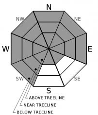
Aspect/Elevation ?
-
Likelihood ?CertainVery LikelyLikelyPossible
 Unlikely
 -
Size ?HistoricVery LargeLargeSmall

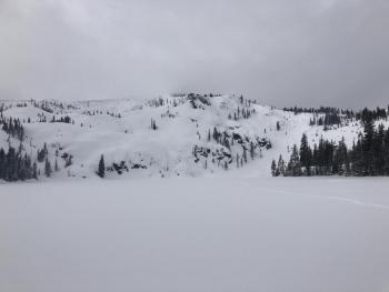
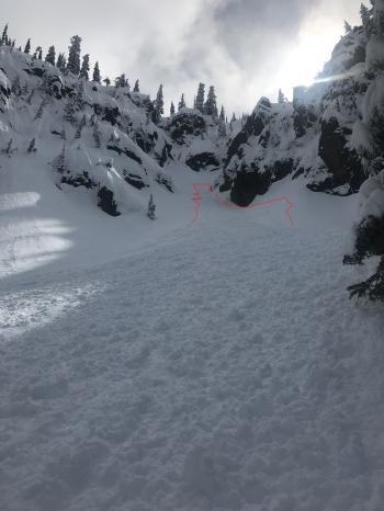
Wind slab avalanches are likely today due to 14 inches of new snow and strong south winds. Light snow showers and wind will continue to grow fresh windslabs on SW-W-NW-N-NE-E aspects. Wind slabs are forming atop a hard melt freeze crust from warmer temperatures observed last weekend. Recent observations have shown the ability for fresh wind slab avalanches to propagate and run long distances. All instabilities observed remained within the new snow or at the new/old snow interface. Light wind and cooler temperatures will allow wind slabs to remain in steep leeward areas today.
Stay away from slopes greater than 35 degrees that have been loaded. Signs that wind slabs may be nearby are: shooting cracks, blocking, whumphing; convex pillows of wind-drifted snow; chalky, hollow sounding snow. Evaluate snow and terrain carefully and identify features of concern.
Forecast Discussion
Stay alive by making conservative decisions and remember the five red flags for avalanche danger; recent avalanches, cracking, blocking, whumphing, significant snowfall in 24 hours, strong winds, and temperature rise. Loose-wet avalanches could be a concern on steep terrain below treeline if temperatures rise higher than expected.
The road to Bunny Flat and Castle Lake is open. Packed snow starting at 5,000 feet was observed on the Everet Memorial highway. Four-wheel drive is recommended.
Recent Observations
A storm total of 14 inches was recorded at 7,600 feet on Mount Shasta over the last 24 hours. Moderate to strong south wind averaged 15 mi/hr with gust to 37 mi/hr at 8,000 feet. The majority of the snow fell between 9 a.m. and 3 p.m. yesterday. Temperatures have stayed in the mid to lower 20's on Mount Shasta.
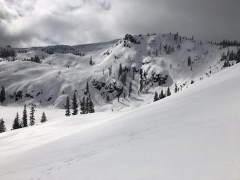
Strong southerly winds, drifting snow, and shooting cracks were observed on a tour up Green Butte. Many test slopes on the west side of the ridge were easy to trigger. Instabilities were confined to the new snow/old snow interface and failed on larger precipitation particles over a hard melt-freeze crust that formed this weekend. Column test showed very easy propagating results failing on isolation numerous times (CTV and ECTV). Surface textures varied with scoured hard snow, 1-2 foot drifts, and soft powder in protected pockets. The strong wind has allowed small drifts with scored areas to form in the trees near and below treeline.
Low visibility and deep snow limited above treeline observations.

Weather and Current Conditions
Weather Summary
Snow showers will linger in portions of the forecast area today. Little accumulation is expected. Another front moves in tonight and will produce increasing wind and heavy snowfall. This slightly warmer front will bring 6-12 inches of snow over the next 48 hours. Snow levels will remain at 4,100 feet today but could rise as high as 4,700 feet tonight. Snow levels will be around 4,500 feet tomorrow. Little accumulation is expected below 5,000 feet. Waves of precip and stormy weather will continue to impact the area for the rest of the week. Drier conditions will return this weekend.
24 Hour Weather Station Data @ 6:00 AM
| Weather Station | Temp (°F) | Wind (mi/hr) | Snow (in) | Comments | ||||||||
|---|---|---|---|---|---|---|---|---|---|---|---|---|
| Cur | Min | Max | Avg | Avg | Max Gust | Dir | Depth | New | Water Equivalent | Settlement | ||
| Mt. Shasta City (3540 ft) | 38 | 26 | 50 | 40 | 1 | N | ||||||
| Sand Flat (6750 ft) | 18 | 18 | 30 | 28 | 142 | 13 | 0 | 1 | ||||
| Ski Bowl (7600 ft) | 17 | 17 | 27 | 24 | 180 | 14 | 1.45 | 1 | ||||
| Gray Butte (8000 ft) | 15.5 | 15.5 | 25 | 22.5 | 15 | 37 | SSE | |||||
| Castle Lake (5870 ft) | 22.5 | 22.5 | 31.5 | 28.5 | 143 | 13 | 0 | |||||
| Mount Eddy (6509 ft) | 18 | 18 | 29.5 | 26 | 2 | 16 | SW | 142 | 14 | 0 | ||
| Ash Creek Bowl (7250 ft) | ||||||||||||
| Ash Creek Ridge (7895 ft) |
Two Day Mountain Weather Forecast
Produced in partnership with the Medford NWS
| For 7000 ft to 9000 ft | |||
|---|---|---|---|
|
Tuesday (4 a.m. to 10 p.m.) |
Tuesday Night (10 p.m. to 4 a.m.) |
Wednesday (4 a.m. to 10 p.m.) |
|
| Weather | Mostly cloudy with a chance of snow showers. Chance of snow 30 percent. | Mostly cloudy with a chance of snow showers. Chance of snow 80 percent. | Snow in the morning, then snow showers in the afternoon |
| Temperature (°F) | 35 | 30 | 35 |
| Wind (mi/hr) | South 5-10 | South 10-15 | South 10-15 |
| Precipitation SWE / Snowfall (in) | / 0-1 | / 2-4 | / 3-6 |
| For 9000 ft to 11000 ft | |||
| Tuesday | Tuesday Night | Wednesday | |
| Weather | Mostly cloudy with a chance of snow showers. Chance of snow 40 percent. | Mostly cloudy with a chance of snow showers. Chance of snow 80 percent. | Snow in the morning, then snow showers in the afternoon |
| Temperature (°F) | 20 | 15 | 20 |
| Wind (mi/hr) | South 15-20 | South 0-1 | South 30-35 |
| Precipitation SWE / Snowfall (in) | / 0-1 | / 2-4 | / 3-6 |
Season Precipitation for Mount Shasta City
| Period | Measured (in) | Normal (in) | Percent of Normal (%) |
|---|---|---|---|
| From Oct 1, 2025 (the wet season) | 33.48 | 34.65 | 97 |
| Month to Date (since Jul 1, 2026) | 3.95 | 5.15 | 77 |
| Year to Date (since Jan 1, 2026) | 25.07 | 19.44 | 129 |

